
Attēls:Patagonia Snow.jpg

Šī priekšskata izmērs: 463 × 599 pikseļi. Citi izmēri: 185 × 240 pikseļi | 371 × 480 pikseļi | 850 × 1 100 pikseļi.
Sākotnējais fails (850 × 1 100 pikseļi, faila izmērs: 903 KB, MIME tips: image/jpeg)
| Šis fails ir no Vikikrātuves. Tā apraksts no attēla lapas Vikikrātuvē ir parādīts zemāk. Vikikrātuve ir brīvi licencēta failu krātuve. Tu vari tai palīdzēt. |
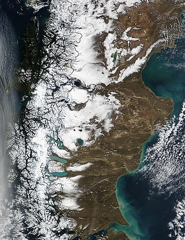
| Apraksts | Snow runs down the spine of the Andes Mountains along the southern tip of South America. Chile is on the left, and Argentina is on the right. The water cutting across the continent in the bottom center of the image is the Strait of Magellan, once the only safe route between the Atlantic and the Pacific Oceans. Along the coast of Argentina, waters of the Atlantic Ocean are tinted green with sediment. |
| Datums | |
| Avots | http://visibleearth.nasa.gov/view_rec.php?id=6061 |
| Autors | Jacques Descloitres, MODIS Rapid Response Team, NASA/GSFC |
| This file is in the public domain in the United States because it was solely created by NASA. NASA copyright policy states that "NASA material is not protected by copyright unless noted". (See Template:PD-USGov, NASA copyright policy page or JPL Image Use Policy.) | ||
 |
Warnings:
|
Faila hronoloģija
Uzklikšķini uz datums/laiks kolonnā esošās saites, lai apskatītos, kā šis fails izskatījās tad.
| Datums/Laiks | Attēls | Izmēri | Dalībnieks | Komentārs | |
|---|---|---|---|---|---|
| tagadējais | 2017. gada 30. oktobris, plkst. 05.28 | | 850 × 1 100 (903 KB) | Janitoalevic | 1998 borders applied. |
| 2006. gada 12. decembris, plkst. 07.16 |  | 850 × 1 100 (323 KB) | Mokono | An Image of the Ptatagonian winter Taken by the Nasa |
Faila lietojums
Šo failu izmanto šajā 1 lapā:
Globālais faila lietojums
Šīs Vikipēdijas izmanto šo failu:
- Izmantojums af.wikipedia.org
- Izmantojums ca.wikipedia.org
- Izmantojums de.wikipedia.org
- Izmantojums el.wikipedia.org
- Izmantojums es.wikipedia.org
- Izmantojums it.wikipedia.org
- Izmantojums ja.wikipedia.org
- Izmantojums nn.wikipedia.org
- Izmantojums pt.wikipedia.org
- Izmantojums uk.wikipedia.org
- Izmantojums zh.wikipedia.org