
Attēls:Puncak Jaya icecap 1972.jpg
Augstāka izšķirtspēja nav pieejama.
Puncak_Jaya_icecap_1972.jpg (650 × 464 pikseļi, faila izmērs: 52 KB, MIME tips: image/jpeg)
| Šis fails ir no Vikikrātuves. Tā apraksts no attēla lapas Vikikrātuvē ir parādīts zemāk. Vikikrātuve ir brīvi licencēta failu krātuve. Tu vari tai palīdzēt. |
Kopsavilkums
| Apraksts |
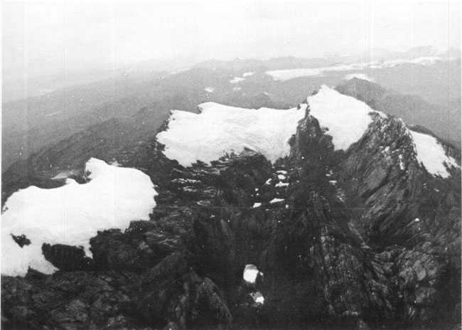
English: Oblique aerial photograph looking east at the glaciers in 1972. Photograph acquired during the Carstensz Glaciers Expeditions (CGE). Left to right: Northwall Firn, Meren Glacier, and Carstensz Glacier. |
| Datums | |
| Avots | Retrieved from [1] and linked from [2] and is a U.S. Government image. |
| Autors | Nezināms at U.S. Geological Survey, U.S.Department of the Interior |
Licence
This image is in the public domain in the United States because it only contains materials that originally came from the United States Geological Survey, an agency of the United States Department of the Interior. For more information, see the official USGS copyright policy.
|
Faila hronoloģija
Uzklikšķini uz datums/laiks kolonnā esošās saites, lai apskatītos, kā šis fails izskatījās tad.
| Datums/Laiks | Attēls | Izmēri | Dalībnieks | Komentārs | |
|---|---|---|---|---|---|
| tagadējais | 2006. gada 16. janvāris, plkst. 13.24 | | 650 × 464 (52 KB) | MONGO | Retrieved from [http://pubs.usgs.gov/prof/p1386h/indonesia/indonesia.html] and linked from [http://pubs.usgs.gov/prof/p1386h/indonesia/infig6.html] and is a U.S. Government image. |
Faila lietojums
Šo failu izmanto šajā 1 lapā:
Globālais faila lietojums
Šīs Vikipēdijas izmanto šo failu:
- Izmantojums arz.wikipedia.org
- Izmantojums az.wikipedia.org
- Izmantojums be-tarask.wikipedia.org
- Izmantojums be.wikipedia.org
- Izmantojums bg.wikipedia.org
- Izmantojums ceb.wikipedia.org
- Izmantojums cs.wikipedia.org
- Izmantojums de.wikipedia.org
- Izmantojums en.wikipedia.org
- Izmantojums en.wikivoyage.org
- Izmantojums eo.wikipedia.org
- Izmantojums es.wikipedia.org
- Izmantojums fr.wikipedia.org
- Izmantojums fr.wikinews.org
- Izmantojums gl.wikipedia.org
- Izmantojums hi.wikipedia.org
- Izmantojums id.wikipedia.org
- Izmantojums it.wikipedia.org
- Izmantojums ja.wikipedia.org
- Izmantojums ka.wikipedia.org
- Izmantojums lld.wikipedia.org
- Izmantojums nl.wikipedia.org
- Izmantojums pt.wikipedia.org
Skatīt šī faila pilno globālo izmantojumu.