Attēls:Qin empire 210 BCE.png

Lapas saturs netiek atbalstīts citās valodās.
Vikipēdijas lapa

Qin_empire_210_BCE.png(555 × 545 pikseļi, faila izmērs: 567 KB, MIME tips: image/png)

Kopsavilkums

Apraksts
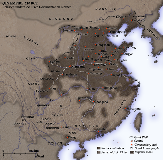
English: Map of the Qin Dynasty (in c. 210 BCE) — in China. ::*The first unifying Imperial dynasty of China. ::*The coloured territories show the approximate extent of Qin political control at the death of Emperor Qin Shi Huang in 210 BC.
As part of his unification of China in 221 BCE, Qin Shi Huang divided his empire into thirty six commanderies, each subdivided into a number of counties. The significance of the administrative reforms was its introduction of a uniformly centralised system of imperial control. At the death of Qin Shi Huang in 210 BCE, more commanderies were added to the original thirty six, and these are also shown on the map.
  • The system was followed by the Han Dynasty (206 BCE – 220 CE), though with a certain degree of compromise. Thereafter, the system became the norm for later dynasties and eventually evolved into the present administrative structure of Mainland China (see: Category: Political divisions of China.) The location of the Yellow River and commandery seats follows Tan Qixiang (ed.), Zhongguo lishi ditu (中国历史地图集), 1982. Note that the Yellow River is considerably to the north of its present flow. ;Credits Created and copyright (2006) by Yeu Ninje. Released under the GNU FDL. Originally uploaded to English Wikipedia by en:User:Yeu Ninje.
  • Han civilisation
    Han civilisation
Datums 1982. (2006).
Avots Self-published work by Itsmine
Autors Itsmine
This historical map image could be re-created using vector graphics as an SVG file. This has several advantages; see Commons:Media for cleanup for more information. If an SVG form of this image is available, please upload it and afterwards replace this template with {{vector version available|new image name}}.


It is recommended to name the SVG file “Qin empire 210 BCE.svg”—then the template Vector version available (or Vva) does not need the new image name parameter.

Licence

Es, šī darba autortiesību īpašnieks, publicēju to saskaņā ar šīm licencēm:
GNU head Ir dota atļauja kopēt, izplatīt un/vai pārveidot šo dokumentu saskaņā ar GNU brīvās dokumentācijas licences, versijas 1.2 vai jebkuras vēlākas versijas, ko publiskojis Brīvās programmatūras fonds nosacījumiem; bez nemainīgajām sadaļā, priekšējā un aizmugurēja'vāka tekstiem. Licences kopija ir iekļauta sadaļā ar nosaukumu GNU brīvās dokumentācijas licence.
w:en:Creative Commons
atsaucoties nemainot licenci
Šis fails tiek izplatīts saskaņā ar licences Creative Commons Atsauce-Līdzīgi Noteikumi 3.0 Vispārējiem noteikumiem.
Jūs varat brīvi:
  • koplietot – kopēt, izplatīt un pārraidīt darbu
  • remiksēt – pielāgot darbu
Saskaņā ar šādiem nosacījumiem:
  • atsaucoties – Tev ir jānorāda autors, saite uz licenci un to, vai veiktas kādas izmaiņas. To var darīt jebkādā saprātīgā veidā, bet ne tādā, kas norādītu, ka licencētājs atbalsta tevi vai veidu, kā tu izmanto šo darbu.
  • nemainot licenci – Ja tu miksē, pārveido vai izmanto materiālu, tev savs devums jāpublicē ar to pašu vai saderīgu licenci kā oriģināls.
This licensing tag was added to this file as part of the GFDL licensing update.
Jūs varat izvēlēties licenci pēc jūsu vēlmes.

Captions

Pievieno vienas rindiņas aprakstu, ko šis fails attēlo
A map of the Qin Dynasty circa 210 BCE.

Šajā failā attēlotais

attēlo

Faila hronoloģija

Uzklikšķini uz datums/laiks kolonnā esošās saites, lai apskatītos, kā šis fails izskatījās tad.

Datums/LaiksAttēlsIzmēriDalībnieksKomentārs
tagadējais2014. gada 10. decembris, plkst. 17.372014. gada 10. decembris, plkst. 17.37 versijas sīktēls555 × 545 (567 KB)Nguyen1310Update to include ''Luo-Yue'' (Vi: ''Lạc Việt'') a member of the Baiyue (100 Yue) peoples, on the map in northern Vietnam.
2006. gada 21. novembris, plkst. 17.082006. gada 21. novembris, plkst. 17.08 versijas sīktēls555 × 545 (540 KB)Itsmine== Commentary == As part of his unification of China in 221 BC, Qin Shi Huang divided his empire into thirty six commanderies, each subdivided into a number of counties. The significance of the administrative reforms was its in

Šo failu izmanto šajā 1 lapā:

Globālais faila lietojums

Šīs Vikipēdijas izmanto šo failu:

Skatīt šī faila pilno globālo izmantojumu.