
Attēls:Resettlement of Circassians Into Ottoman Empire.jpg
Šī priekšskata izmērs: 800 × 426 pikseļi. Citi izmēri: 320 × 171 pikseļi | 640 × 341 pikseļi | 1 199 × 639 pikseļi.
Sākotnējais fails (1 199 × 639 pikseļi, faila izmērs: 420 KB, MIME tips: image/jpeg)
| Šis fails ir no Vikikrātuves. Tā apraksts no attēla lapas Vikikrātuvē ir parādīts zemāk. Vikikrātuve ir brīvi licencēta failu krātuve. Tu vari tai palīdzēt. |

|
This map image could be re-created using vector graphics as an SVG file. This has several advantages; see Commons:Media for cleanup for more information. If an SVG form of this image is available, please upload it and afterwards replace this template with
{{vector version available|new image name}}.
It is recommended to name the SVG file “Resettlement of Circassians Into Ottoman Empire.svg”—then the template Vector version available (or Vva) does not need the new image name parameter. |


Kopsavilkums
| Apraksts |
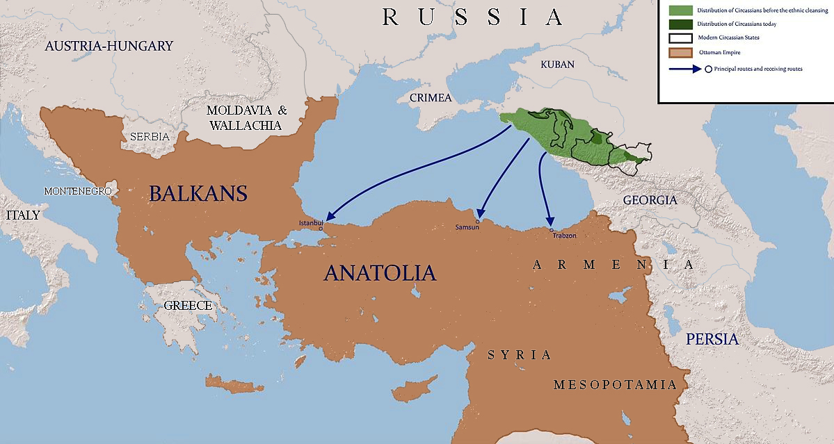
English: map shows the routes which were used to resettle circassians to ottoman empire |
| Datums | |
| Avots | using paint.net |
| Autors | Ercwlff |
| Citas versijas |
 |
Licence
Es, šī darba autortiesību īpašnieks, publicēju to saskaņā ar šīm licencēm:

|
Ir dota atļauja kopēt, izplatīt un/vai pārveidot šo dokumentu saskaņā ar GNU brīvās dokumentācijas licences, versijas 1.2 vai jebkuras vēlākas versijas, ko publiskojis Brīvās programmatūras fonds nosacījumiem; bez nemainīgajām sadaļā, priekšējā un aizmugurēja'vāka tekstiem. Licences kopija ir iekļauta sadaļā ar nosaukumu GNU brīvās dokumentācijas licence. |
Šis fails tiek izplatīts saskaņā ar licences Creative Commons Atsauce-Līdzīgi Noteikumi 3.0 Vispārējiem noteikumiem.
- Jūs varat brīvi:
- koplietot – kopēt, izplatīt un pārraidīt darbu
- remiksēt – pielāgot darbu
- Saskaņā ar šādiem nosacījumiem:
- atsaucoties – Tev ir jānorāda autors, saite uz licenci un to, vai veiktas kādas izmaiņas. To var darīt jebkādā saprātīgā veidā, bet ne tādā, kas norādītu, ka licencētājs atbalsta tevi vai veidu, kā tu izmanto šo darbu.
- nemainot licenci – Ja tu miksē, pārveido vai izmanto materiālu, tev savs devums jāpublicē ar to pašu vai saderīgu licenci kā oriģināls.
Jūs varat izvēlēties licenci pēc jūsu vēlmes.
|
|
This historical map image could be re-created using vector graphics as an SVG file. This has several advantages; see Commons:Media for cleanup for more information. If an SVG form of this image is available, please upload it and afterwards replace this template with
{{vector version available|new image name}}.
It is recommended to name the SVG file “Resettlement of Circassians Into Ottoman Empire.svg”—then the template Vector version available (or Vva) does not need the new image name parameter. |
Faila hronoloģija
Uzklikšķini uz datums/laiks kolonnā esošās saites, lai apskatītos, kā šis fails izskatījās tad.
| Datums/Laiks | Attēls | Izmēri | Dalībnieks | Komentārs | |
|---|---|---|---|---|---|
| tagadējais | 2021. gada 5. aprīlis, plkst. 20.50 | | 1 199 × 639 (420 KB) | Claude Zygiel | Ottoman borders 1864-67 during the Circassian ressettlement |
| 2020. gada 4. oktobris, plkst. 14.47 |  | 1 199 × 639 (421 KB) | Ориенталист | More correct map, Greece is independent, Bessarabia is part of Russia | |
| 2015. gada 23. maijs, plkst. 12.59 |  | 1 782 × 950 (425 KB) | Ercwlff | {{subst:Upload marker added by en.wp UW}} {{Information |Description = {{en|map shows the routes which were used to resettle circassians to ottoman empire}} |Source = using paint.net |Date = 2015-05-23 |Author = IrakliGuna }} |
Faila lietojums
Šo failu izmanto šajās 3 lapās:
Globālais faila lietojums
Šīs Vikipēdijas izmanto šo failu:
- Izmantojums ar.wikipedia.org
- Izmantojums be-tarask.wikipedia.org
- Izmantojums bn.wikipedia.org
- Izmantojums en.wikipedia.org
- Izmantojums et.wikipedia.org
- Izmantojums fa.wikipedia.org
- Izmantojums fr.wikipedia.org
- Izmantojums he.wikipedia.org
- Izmantojums ja.wikipedia.org
- Izmantojums ko.wikipedia.org
- Izmantojums nl.wikipedia.org
- Izmantojums no.wikipedia.org
- Izmantojums pl.wikipedia.org
- Izmantojums pnb.wikipedia.org
- Izmantojums ru.wikipedia.org
- Izmantojums sl.wikipedia.org
- Izmantojums sr.wikipedia.org
- Izmantojums ur.wikipedia.org