
Attēls:Romani population average estimate.png
Romani_population_average_estimate.png (788 × 596 pikseļi, faila izmērs: 160 KB, MIME tips: image/png)
| Šis fails ir no Vikikrātuves. Tā apraksts no attēla lapas Vikikrātuvē ir parādīts zemāk. Vikikrātuve ir brīvi licencēta failu krātuve. Tu vari tai palīdzēt. |

|
This map image could be re-created using vector graphics as an SVG file. This has several advantages; see Commons:Media for cleanup for more information. If an SVG form of this image is available, please upload it and afterwards replace this template with
{{vector version available|new image name}}.
It is recommended to name the SVG file “Romani population average estimate.svg”—then the template Vector version available (or Vva) does not need the new image name parameter. |
Kopsavilkums
| Apraksts |
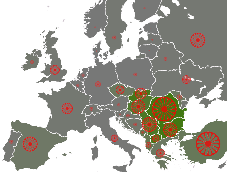
populations of the țigani people by country, showing the "average estimate" published by the Council of Europe[1] (Archived from the original). Based on these estimates are the number of seats by country in the European Roma and Travellers Forum (ERTF) based in Strasbourg. The size of the wheel symbol represents total population by country (Romania 1.85 million), the shade of each country's background colour represents the percentage of Romani with respect to the total population (Romania 8.5%). 0%
5%
10% |
| Datums | (UTC) |
| Avots | |
| Autors |
|
| Citas versijas | File:Roma in Europe 2007 cropped.png |
Licence

|
Ir dota atļauja kopēt, izplatīt un/vai pārveidot šo dokumentu saskaņā ar GNU brīvās dokumentācijas licences, versijas 1.2 vai jebkuras vēlākas versijas, ko publiskojis Brīvās programmatūras fonds nosacījumiem; bez nemainīgajām sadaļā, priekšējā un aizmugurēja'vāka tekstiem. Licences kopija ir iekļauta sadaļā ar nosaukumu GNU brīvās dokumentācijas licence. |
| Šis fails tiek izplatīts saskaņā ar licences Creative Commons Atsauce-Līdzīgi Noteikumi 3.0 Vispārējiem noteikumiem. | ||
| Atsauce: Dbachmann | ||
| ||
| This licensing tag was added to this file as part of the GFDL licensing update. |
Original upload log
This image is a derivative work of the following images:
- File:Europe_blank_map.png licensed with PD-user
- 2008-08-04T13:35:42Z Avala 1360x1245 (86403 Bytes) http://news.xinhuanet.com/english/2008-02/19/content_7629464.htm
- 2008-08-01T02:34:17Z Wikibob 1360x1245 (86480 Bytes) Reverted to version as of 16:34, 13 March 2008
- 2008-07-31T14:52:04Z Avala 1360x1245 (86403 Bytes)
- 2008-03-22T21:58:51Z Nightstallion 1360x1245 (86480 Bytes) Reverted to version as of 16:34, 13 March 2008
- 2008-03-19T19:36:05Z Patstuart 1360x1245 (86403 Bytes) Reverted to version as of 18:15, 11 March 2008 - see [[Image talk:BlankMap-World-v6.png#As stated in reversion]]
- 2008-03-13T16:34:01Z Nightstallion 1360x1245 (86480 Bytes) upload a variant if you wish, but the majority in Europe recognises or will recognise.
- 2008-03-11T18:15:58Z Avala 1360x1245 (86403 Bytes) there is no consensus in Europe
- 2008-02-24T14:02:27Z Hoshie 1360x1245 (86480 Bytes) Added Kosovo since it has been internationally recognized
- 2006-06-10T00:20:20Z QuartierLatin1968 1360x1245 (86403 Bytes) Montenegro is now independent; widespread recognition can be expected within the next few weeks
- 2005-08-31T22:16:23Z Gugganij 1360x1245 (47472 Bytes) and again some changes
- 2005-08-31T22:09:44Z Gugganij 1360x1245 (49669 Bytes) some minor changes
- 2005-03-26T19:56:55Z Wiki-vr 1245x1245 (54567 Bytes) Blank map of Europe - use to show countries' locations, EU members, etc. – see examples: *http://commons.wikimedia.org/wiki/Image:EU_Members_Candidates_2004_2007.png *http://commons.wikimedia.org/wiki/Image:Europe_location
Uploaded with derivativeFX
Faila hronoloģija
Uzklikšķini uz datums/laiks kolonnā esošās saites, lai apskatītos, kā šis fails izskatījās tad.
| Datums/Laiks | Attēls | Izmēri | Dalībnieks | Komentārs | |
|---|---|---|---|---|---|
| tagadējais | 2009. gada 22. janvāris, plkst. 17.30 | | 788 × 596 (160 KB) | Dbachmann | {{Information |Description=populations of the Romani people by country, showing the "average estimate" published by the Council of Europe[http://www.coe.int/t/dg3/romatravellers/Documentation/strategies/statistiques_en.asp#P11_143]. Based on these estimat |
Faila lietojums
Šo failu izmanto šajā 1 lapā:
Globālais faila lietojums
Šīs Vikipēdijas izmanto šo failu:
- Izmantojums af.wikipedia.org
- Izmantojums ast.wikipedia.org
- Izmantojums azb.wikipedia.org
- Izmantojums ca.wikipedia.org
- Izmantojums cs.wikipedia.org
- Izmantojums da.wikipedia.org
- Izmantojums en.wikipedia.org
- Izmantojums en.wikinews.org
- Izmantojums eo.wikipedia.org
- Izmantojums es.wikipedia.org
- Izmantojums fr.wikipedia.org
- Izmantojums ga.wikipedia.org
- Izmantojums hi.wikipedia.org
- Izmantojums hu.wikipedia.org
- Izmantojums it.wikipedia.org
- Izmantojums la.wikipedia.org
- Izmantojums lt.wikipedia.org
- Izmantojums pt.wikipedia.org
- Izmantojums sr.wikipedia.org
- Izmantojums wa.wikipedia.org