
Attēls:Stewart Island map-en.svg

Size of this PNG preview of this SVG file: 800 × 585 pikseļi. Citi izmēri: 320 × 234 pikseļi | 640 × 468 pikseļi | 1 024 × 748 pikseļi | 1 280 × 936 pikseļi | 2 560 × 1 871 pikseļi | 2 237 × 1 635 pikseļi.
Sākotnējais fails (SVG fails, definētais izmērs 2 237 × 1 635 pikseļi, faila izmērs: 1,7 MB)
| Šis fails ir no Vikikrātuves. Tā apraksts no attēla lapas Vikikrātuvē ir parādīts zemāk. Vikikrātuve ir brīvi licencēta failu krātuve. Tu vari tai palīdzēt. |
Kopsavilkums
| Apraksts |
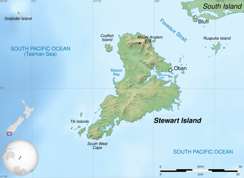
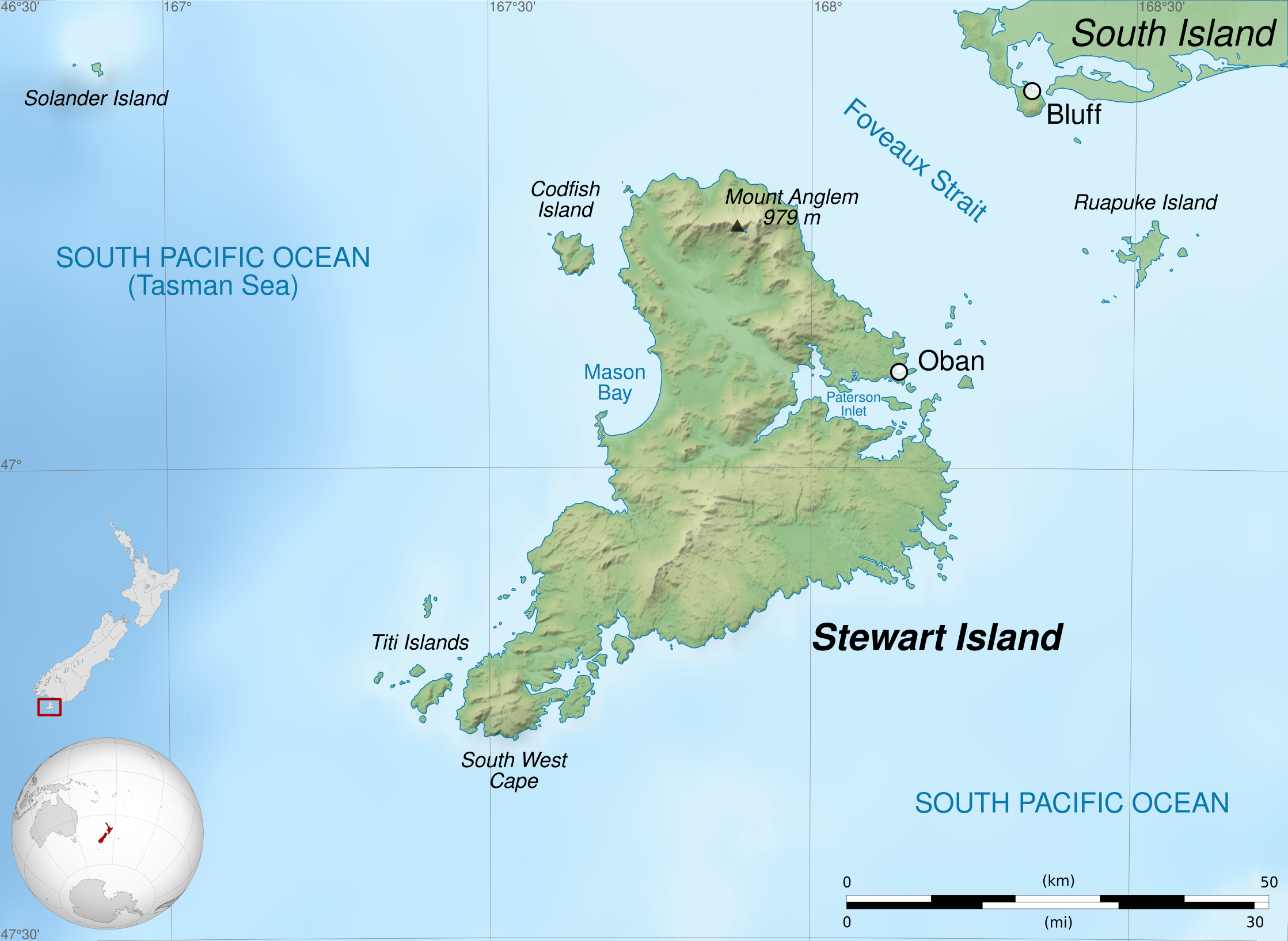
English: Map of Stewart Island / Rakiura, New Zealand.
Geographic limits of the map:
Français : Carte de l'île Stewart, au sud de la Nouvelle-Zélande.
Limites géographiques de la carte :
|
||
| Datums | |||
| Avots |
Paša darbs. English:
Français : |
||
| Autors | Sémhur (talk) | ||
| Citas versijas |
| ||
| Atsauce (required by the license) | © Sémhur / Wikimedia Commons / | ||
| SVG | W3C-validity not checked.
|
||
| Graphic Lab |


| Camera location | | View this and other nearby images on: OpenStreetMap |
|---|
Licence
Es, šī darba autortiesību īpašnieks, publicēju to saskaņā ar šīm licencēm:
| Copyleft: This work of art is free; you can redistribute it and/or modify it according to terms of the Free Art License. You will find a specimen of this license on the Copyleft Attitude site as well as on other sites. |
This file is licensed under the Creative Commons Attribution-Share Alike 4.0 International, 3.0 Unported, 2.5 Generic, 2.0 Generic and 1.0 Generic license.
- Jūs varat brīvi:
- koplietot – kopēt, izplatīt un pārraidīt darbu
- remiksēt – pielāgot darbu
- Saskaņā ar šādiem nosacījumiem:
- atsaucoties – Tev ir jānorāda autors, saite uz licenci un to, vai veiktas kādas izmaiņas. To var darīt jebkādā saprātīgā veidā, bet ne tādā, kas norādītu, ka licencētājs atbalsta tevi vai veidu, kā tu izmanto šo darbu.
- nemainot licenci – Ja tu miksē, pārveido vai izmanto materiālu, tev savs devums jāpublicē ar to pašu vai saderīgu licenci kā oriģināls.
Jūs varat izvēlēties licenci pēc jūsu vēlmes.
Faila hronoloģija
Uzklikšķini uz datums/laiks kolonnā esošās saites, lai apskatītos, kā šis fails izskatījās tad.
| Datums/Laiks | Attēls | Izmēri | Dalībnieks | Komentārs | |
|---|---|---|---|---|---|
| tagadējais | 2020. gada 4. februāris, plkst. 00.39 | | 2 237 × 1 635 (1,7 MB) | Sémhur | Correct scale |
| 2014. gada 2. jūnijs, plkst. 10.58 |  | 2 237 × 1 635 (1,7 MB) | Sémhur | Valid SVG | |
| 2011. gada 28. aprīlis, plkst. 00.22 |  | 2 237 × 1 635 (1,7 MB) | Sémhur | == {{int:filedesc}} == {{Information |Description={{Multilingual description |en=Map of en:Stewart Island / Rakiura, New Zealand. * Altitude levels: 50 m, 125, 250, 500, etc. (same for bathymetry). * Projection: New Zealand Geodetic Datum 2000 ; GRS |
Faila lietojums
Šo failu izmanto šajā 1 lapā:
Globālais faila lietojums
Šīs Vikipēdijas izmanto šo failu:
- Izmantojums ast.wikipedia.org
- Izmantojums bn.wikipedia.org
- Izmantojums br.wikipedia.org
- Izmantojums de.wikipedia.org
- Izmantojums en.wikipedia.org
- Izmantojums fa.wikipedia.org
- Izmantojums fi.wikipedia.org
- Izmantojums gl.wikipedia.org
- Izmantojums hu.wikipedia.org
- Izmantojums kw.wikipedia.org
- Izmantojums lt.wikipedia.org
- Izmantojums ml.wikipedia.org
- Izmantojums nl.wikipedia.org
- Izmantojums no.wikipedia.org
- Izmantojums pl.wikipedia.org
- Izmantojums simple.wikipedia.org
- Izmantojums sl.wikipedia.org
- Izmantojums sv.wikipedia.org
- Izmantojums ta.wikipedia.org
- Izmantojums th.wikipedia.org
- Izmantojums uk.wikipedia.org
- Izmantojums vi.wikipedia.org
- Izmantojums zh.wikipedia.org