
Attēls:Tanggu Truce Map.jpg

Šī priekšskata izmērs: 794 × 600 pikseļi. Citi izmēri: 318 × 240 pikseļi | 635 × 480 pikseļi | 1 016 × 768 pikseļi | 1 280 × 967 pikseļi | 1 985 × 1 500 pikseļi.
Sākotnējais fails (1 985 × 1 500 pikseļi, faila izmērs: 403 KB, MIME tips: image/jpeg)
| Šis fails ir no Vikikrātuves. Tā apraksts no attēla lapas Vikikrātuvē ir parādīts zemāk. Vikikrātuve ir brīvi licencēta failu krātuve. Tu vari tai palīdzēt. |
Kopsavilkums
| Apraksts |
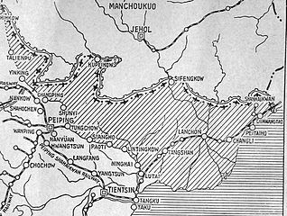
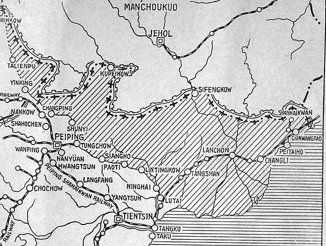
English: The shaded part of this map shows the areas demilitarized by the Tanggu Truce. Note also that the remainder of the Hebei Province, including Beijing and Tianjin, would also be demilitarized of Nationalist forces under the terms of the He-Umezu Agreement, but independent warlords like Song Zheyuan continued to operate there. |
| Datums | |
| Avots | a pamphlet called "Sino-Japanese Conflict Elucidated" |
| Autors | Canadian Japanese Association |
Licence
This Canadian work, of which the author or authors are unknown, is in the public domain in Canada because:
(R.S.C., 2020, c. C-42, s. 6.1, R.S.C., 1993, c. C-42, s. 6.1) |
 | |
|
|
Faila hronoloģija
Uzklikšķini uz datums/laiks kolonnā esošās saites, lai apskatītos, kā šis fails izskatījās tad.
| Datums/Laiks | Attēls | Izmēri | Dalībnieks | Komentārs | |
|---|---|---|---|---|---|
| tagadējais | 2012. gada 19. oktobris, plkst. 01.47 | | 1 985 × 1 500 (403 KB) | CurtisNaito | User created page with UploadWizard |
Faila lietojums
Šo failu izmanto šajās 2 lapās:
Globālais faila lietojums
Šīs Vikipēdijas izmanto šo failu:
- Izmantojums ar.wikipedia.org
- Izmantojums en.wikipedia.org
- Izmantojums es.wikipedia.org
- Izmantojums fa.wikipedia.org
- Izmantojums fr.wikipedia.org
- Izmantojums it.wikipedia.org
- Izmantojums ko.wikipedia.org
- Izmantojums nl.wikipedia.org
- Izmantojums pt.wikipedia.org
- Izmantojums ru.wikipedia.org
- Izmantojums uk.wikipedia.org