
Attēls:Tibetan empire greatest extent 780s-790s CE.png

Šī priekšskata izmērs: 790 × 600 pikseļi. Citi izmēri: 316 × 240 pikseļi | 632 × 480 pikseļi | 1 011 × 768 pikseļi | 1 280 × 972 pikseļi | 1 792 × 1 361 pikseļi.
Sākotnējais fails (1 792 × 1 361 pikseļi, faila izmērs: 4,55 MB, MIME tips: image/png)
| Šis fails ir no Vikikrātuves. Tā apraksts no attēla lapas Vikikrātuvē ir parādīts zemāk. Vikikrātuve ir brīvi licencēta failu krātuve. Tu vari tai palīdzēt. |
Kopsavilkums

|
This historical map image could be re-created using vector graphics as an SVG file. This has several advantages; see Commons:Media for cleanup for more information. If an SVG form of this image is available, please upload it and afterwards replace this template with
{{vector version available|new image name}}.
It is recommended to name the SVG file “Tibetan empire greatest extent 780s-790s CE.svg”—then the template Vector version available (or Vva) does not need the new image name parameter. |
| Apraksts |
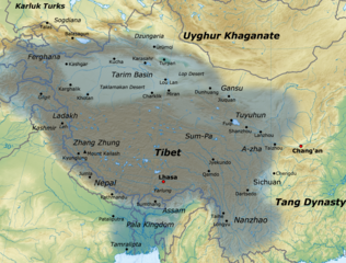
English: Map of the Tibetan Empire at its greatest extent between the 780s and the 790s CE
sources:
|
| Datums | |
| Avots | Paša darbs |
| Autors | Javierfv1212 |
Licence
Es, šī darba autortiesību īpašnieks, publicēju to saskaņā ar šo licenci:
Šis fails tiek izplatīts saskaņā ar licences Creative Commons Atsauce 3.0 Vispārējiem noteikumiem.
- Jūs varat brīvi:
- koplietot – kopēt, izplatīt un pārraidīt darbu
- remiksēt – pielāgot darbu
- Saskaņā ar šādiem nosacījumiem:
- atsaucoties – Tev ir jānorāda autors, saite uz licenci un to, vai veiktas kādas izmaiņas. To var darīt jebkādā saprātīgā veidā, bet ne tādā, kas norādītu, ka licencētājs atbalsta tevi vai veidu, kā tu izmanto šo darbu.
Faila hronoloģija
Uzklikšķini uz datums/laiks kolonnā esošās saites, lai apskatītos, kā šis fails izskatījās tad.
| Datums/Laiks | Attēls | Izmēri | Dalībnieks | Komentārs | |
|---|---|---|---|---|---|
| tagadējais | 2021. gada 16. janvāris, plkst. 19.11 | | 1 792 × 1 361 (4,55 MB) | Liandrei | Cropped black border |
| 2011. gada 29. marts, plkst. 19.00 |  | 1 800 × 1 361 (4,56 MB) | Javierfv1212 | {{Information |Description ={{en|1=Map of the Tibetan empire at it's Greatest extent between the 780s and the 790s CE sources: http://academic.reed.edu/anthro/364/maps.html http://unitednations4freetibet.com/unfft/wp-content/uploads/2010/11/The-Nation |
Faila lietojums
Šo failu izmanto šajā 1 lapā:
Globālais faila lietojums
Šīs Vikipēdijas izmanto šo failu:
- Izmantojums af.wikipedia.org
- Izmantojums ar.wikipedia.org
- Izmantojums azb.wikipedia.org
- Izmantojums az.wikipedia.org
- Izmantojums ba.wikipedia.org
- Izmantojums bg.wikipedia.org
- Izmantojums bn.wikipedia.org
- Izmantojums bo.wikipedia.org
- Izmantojums bs.wikipedia.org
- Izmantojums ca.wikipedia.org
- Izmantojums cs.wikipedia.org
- Izmantojums da.wikipedia.org
- Izmantojums de.wikipedia.org
- Izmantojums en.wikipedia.org
- Izmantojums es.wikipedia.org
- Izmantojums eu.wikipedia.org
- Izmantojums fa.wikipedia.org
- Izmantojums fi.wikipedia.org
- Izmantojums fr.wikipedia.org
Skatīt šī faila pilno globālo izmantojumu.