
Attēls:Trebizond1400.png
Augstāka izšķirtspēja nav pieejama.
Trebizond1400.png (635 × 401 pikseļi, faila izmērs: 107 KB, MIME tips: image/png)
| Šis fails ir no Vikikrātuves. Tā apraksts no attēla lapas Vikikrātuvē ir parādīts zemāk. Vikikrātuve ir brīvi licencēta failu krātuve. Tu vari tai palīdzēt. |
Kopsavilkums
| Apraksts |
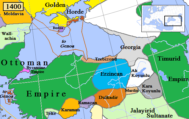
English: Trebizond and surrounding states in Anatolia/Caucasus in AD 1400.
(Partially based on Euratlas map of Europe, 1400, improved since Koza Yayınları Tarih Atlası sf.42; Kanaat Yayınları Tarih Atlası sf.28; Mutafian, Claude & Van Lauwe, Eric: Atlas historique de l'Arménie, Autrement publ., coll. «Atlas/Memoires», Paris 2001, ISBN 2-7467-0100-6 and since the graphic style of [1]) |
| Datums | |
| Avots | Paša darbs |
| Autors | Gabagool |
![[1]](http://vignette3.wikia.nocookie.net/genealogy/images/c/cf/Trebizond1300.png/revision/latest/thumbnail-down/width/340/height/340?cb=20110516182142)

|
This historical map image could be re-created using vector graphics as an SVG file. This has several advantages; see Commons:Media for cleanup for more information. If an SVG form of this image is available, please upload it and afterwards replace this template with
{{vector version available|new image name}}.
It is recommended to name the SVG file “Trebizond1400.svg”—then the template Vector version available (or Vva) does not need the new image name parameter. |
Licence
Es, šī darba autortiesību īpašnieks, publicēju to saskaņā ar šo licenci:
Šis fails tiek izplatīts saskaņā ar licences Creative Commons Atsauce 3.0 Vispārējiem noteikumiem.
- Jūs varat brīvi:
- koplietot – kopēt, izplatīt un pārraidīt darbu
- remiksēt – pielāgot darbu
- Saskaņā ar šādiem nosacījumiem:
- atsaucoties – Tev ir jānorāda autors, saite uz licenci un to, vai veiktas kādas izmaiņas. To var darīt jebkādā saprātīgā veidā, bet ne tādā, kas norādītu, ka licencētājs atbalsta tevi vai veidu, kā tu izmanto šo darbu.
Faila hronoloģija
Uzklikšķini uz datums/laiks kolonnā esošās saites, lai apskatītos, kā šis fails izskatījās tad.
| Datums/Laiks | Attēls | Izmēri | Dalībnieks | Komentārs | |
|---|---|---|---|---|---|
| tagadējais | 2018. gada 6. aprīlis, plkst. 14.03 | | 635 × 401 (107 KB) | Trecătorul răcit | Little changes since ''Koza Yayınları Tarih Atlası'' sf.42; ''Kanaat Yayınları Tarih Atlası'' sf.28; Mutafian, Claude & Van Lauwe, Eric: ''Atlas historique de l'Arménie'', Autrement publ., coll. «Atlas/Memoires», Paris 2001, ISBN 2-7467-0100-6 and since the graphic style of [http://vignette3.wikia.nocookie.net/genealogy/images/c/cf/Trebizond1300.png/revision/latest/thumbnail-down/width/340/height/340?cb=20110516182142] |
| 2009. gada 18. aprīlis, plkst. 01.45 |  | 635 × 401 (82 KB) | Gabagool | {{Information |Description={{en|1=Trebizond and surrounding states in Anatolia/Caucasus in AD 1400. (Partially based on Euratlas map of Europe, 1400.)}} |Source=Own work by uploader |Author=Gabagool |Date=2009-04-18 |Permission= |other_ |
Faila lietojums
Šo failu izmanto šajā 1 lapā:
Globālais faila lietojums
Šīs Vikipēdijas izmanto šo failu:
- Izmantojums ast.wikipedia.org
- Izmantojums azb.wikipedia.org
- Izmantojums dsb.wikipedia.org
- Izmantojums el.wikipedia.org
- Izmantojums en.wikipedia.org
- Izmantojums et.wikipedia.org
- Izmantojums fiu-vro.wikipedia.org
- Izmantojums fi.wikipedia.org
- Izmantojums fr.wikipedia.org
- Izmantojums gl.wikipedia.org
- Izmantojums he.wikipedia.org
- Izmantojums hsb.wikipedia.org
- Izmantojums hu.wikipedia.org
- Komnénosz Teodóra iráni királyné
- Komnénosz Mária trapezunti császári hercegnő (1328–1408)
- Komnénosz Teodóra trapezunti császári hercegnő (?–1435)
- Komnénosz Mária bizánci császárné
- Márta iráni hercegnő
- Caterino Zeno
- Komnénosz Eudokia trapezunti császári hercegnő (IV. Alexiosz lánya)
- Crispo Miklós naxoszi herceg
- Crispo Jolán naxoszi hercegnő
- IV. Ióannész trapezunti császár
- Bagrationi N. trapezunti császárné
- Szeldzsukida Tamar grúz királyné
- Cicisvili Sziti grúz királyné
- II. Dávid trapezunti császár
- Komnénosz N. guriai fejedelemné
- Gabrasz Mária gotthiai hercegnő
- I. Sándor imereti király
- Szeldzsukida Gulsari imereti királyné
- Szeldzsukida Demeter imereti herceg
- Grúz Királyság
- Izmantojums id.wikipedia.org
- Izmantojums it.wikipedia.org
- Izmantojums ka.wikipedia.org
- Izmantojums lt.wikipedia.org
- Izmantojums pt.wikipedia.org
- Izmantojums ru.wikipedia.org
- Izmantojums sr.wikipedia.org
- Izmantojums sv.wikipedia.org
- Izmantojums tr.wikipedia.org
- Izmantojums uk.wikipedia.org
Skatīt šī faila pilno globālo izmantojumu.