
Attēls:Waldseemuller map 2.jpg

Sākotnējais fails (13 708 × 7 590 pikseļi, faila izmērs: 19,65 MB, MIME tips: image/jpeg)
| Šis fails ir no Vikikrātuves. Tā apraksts no attēla lapas Vikikrātuvē ir parādīts zemāk. Vikikrātuve ir brīvi licencēta failu krātuve. Tu vari tai palīdzēt. |
Kopsavilkums
| Warning | The original file is very high-resolution. It might not load properly or could cause your browser to freeze when opened at full size. |
|---|
| Apraksts |
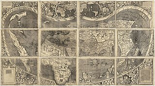
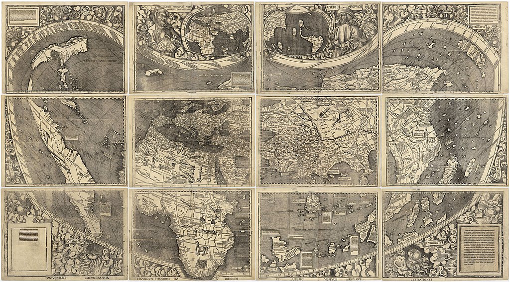
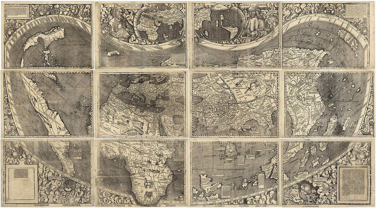
العربية: خريطة ڤالدسيمولير العائدة لِسنة 1507م. هذه الخريطة هي الأولى التي أوردت اسم «أمريكا» وأوَّل خريطة فصلت الأمريكتين عن آسيا. هذه النسخة هي الوحيدة الباقية، وقد اشترتها مكتبة الكونغرس سنة 2001م مُقابل 10 ملايين دولار أمريكي.
English: Waldseemüller map from 1507 is the first map to include the name "America" and the first to depict the Americas as separate from Asia. There is only one surviving copy of the map, which was purchased by the Library of Congress in 2001 for $10 million.
Français : Le planisphère de Waldseemüller de 1507 est la première carte mentionnant le nom "America" et la première à décrire les Amériques séparées de l'Asie. Il ne reste plus qu'une seule copie du planisphère encore existante à ce jour, acquise par la bibliothèque du Congrès en 2001 pour la somme de 10 millions de dollars. |
|||||||||||||||||||||||
| Datums | ||||||||||||||||||||||||
| Avots | https://www.loc.gov/resource/g3200.ct000725 | |||||||||||||||||||||||
| Autors |
|
|||||||||||||||||||||||
| Citas versijas |
|
|||||||||||||||||||||||


Assessment
|

Licence
|
This work is in the public domain in its country of origin and other countries and areas where the copyright term is the author's life plus 100 years or fewer. Šis attēls ir publiskā lietošanā ASV teritorijā saskaņā ar ASV likumiem un normatīvajiem aktiem, jo ir pirmo reizi publicēts pirms 1929. gada 1. janvāra, vai ir publiskā lietošanā saskaņā ar citām juridiskām prasībām.. | |
| This file has been identified as being free of known restrictions under copyright law, including all related and neighboring rights. | |
Faila hronoloģija
Uzklikšķini uz datums/laiks kolonnā esošās saites, lai apskatītos, kā šis fails izskatījās tad.
| Datums/Laiks | Attēls | Izmēri | Dalībnieks | Komentārs | |
|---|---|---|---|---|---|
| tagadējais | 2008. gada 27. oktobris, plkst. 20.37 | | 13 708 × 7 590 (19,65 MB) | Jackaranga | {{Information |Description={{en|1=waldseemuller map, full page from http://memory.loc.gov/cgi-bin/map_item.pl?data=/home/www/data/gmd/gmd3/g3200/g3200/ct000725.jp2&style=gmd&itemLink=r?ammem/gmd:@field(NUMBER+@band(g3200+ct000725))&title=Universalis%20cos |
Faila lietojums
Šo failu izmanto šajā 1 lapā:
Globālais faila lietojums
Šīs Vikipēdijas izmanto šo failu:
- Izmantojums af.wikipedia.org
- Izmantojums als.wikipedia.org
- Izmantojums ar.wikipedia.org
- بوابة:جغرافيا
- الأمريكتان
- العصر الحديث
- خريطة فالدسيمولير
- استكشاف أمريكا الشمالية
- بوابة:جغرافيا/صورة مختارة/أرشيف
- ويكيبيديا:صور مختارة/رسومات وجداول وخرائط/خرائط
- ويكيبيديا:ترشيحات الصور المختارة/خريطة فالدسيمولير
- ويكيبيديا:صورة اليوم المختارة/مارس 2018
- قالب:صورة اليوم المختارة/2018-03-24
- بوابة:جغرافيا/صورة مختارة/13
- ويكيبيديا:صورة اليوم المختارة/سبتمبر 2022
- قالب:صورة اليوم المختارة/2022-09-03
- Izmantojums ast.wikipedia.org
- Izmantojums az.wikipedia.org
- Izmantojums bg.wikipedia.org
- Izmantojums bn.wikipedia.org
- Izmantojums br.wikipedia.org
- Izmantojums ca.wikipedia.org
- Izmantojums cs.wikipedia.org
- Izmantojums cy.wikipedia.org
- Izmantojums da.wikipedia.org
- Izmantojums de.wikipedia.org
- 16. Jahrhundert
- Christoph Kolumbus
- Neuzeit
- Martin Waldseemüller
- Weltkarte
- Benutzer:Mondamo/karten
- Liste historischer Weltkarten
- UNESCO-Kultur- und -Naturerbe
- Benutzer:GiFontenelle/Entwurf/Q131454, bibliothek
- Benutzer:Muhali/Waldseemüller Karte
- Benutzer:Springen/Waldseemüller-Karte
- Benutzer:Cupkake4Yoshi/History of geography
- Cosmographiae Introductio
- Izmantojums el.wikipedia.org
- Izmantojums en.wikipedia.org
Skatīt šī faila pilno globālo izmantojumu.