
Attēls:West-Slavic peoples until 1125.jpg

Šī priekšskata izmērs: 442 × 600 pikseļi. Citi izmēri: 177 × 240 pikseļi | 353 × 480 pikseļi | 943 × 1 280 pikseļi.
Sākotnējais fails (943 × 1 280 pikseļi, faila izmērs: 387 KB, MIME tips: image/jpeg)
| Šis fails ir no Vikikrātuves. Tā apraksts no attēla lapas Vikikrātuvē ir parādīts zemāk. Vikikrātuve ir brīvi licencēta failu krātuve. Tu vari tai palīdzēt. |
Kopsavilkums
| Apraksts |
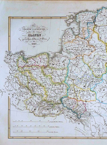
English: Map shows Kingdom of Poland (R. Poloniae) around 1125 - dark green borders - with its provinces: Greater Poland and Lesser Poland (yellow borders), Silesia, Masovia, Pomerania (with Gdańsk Pomerania - M: Gdansk). |
| Datums | |
| Avots | Historisch Geographischer Handatlas, zweite Abtheilung, zweite Auflage, Justus Pertes |
| Autors | Dr. Karl von Spruner |
Licence
This media file is in the public domain in the United States. This applies to U.S. works where the copyright has expired, often because its first publication occurred prior to January 1, 1929, and if not then due to lack of notice or renewal. See this page for further explanation.
|
 | |
 |
This image might not be in the public domain outside of the United States; this especially applies in the countries and areas that do not apply the rule of the shorter term for US works, such as Canada, Mainland China (not Hong Kong or Macao), Germany, Mexico, and Switzerland. The creator and year of publication are essential information and must be provided. See Wikipedia:Public domain and Wikipedia:Copyrights for more details.
|
Faila hronoloģija
Uzklikšķini uz datums/laiks kolonnā esošās saites, lai apskatītos, kā šis fails izskatījās tad.
| Datums/Laiks | Attēls | Izmēri | Dalībnieks | Komentārs | |
|---|---|---|---|---|---|
| tagadējais | 2012. gada 8. augusts, plkst. 16.49 | | 943 × 1 280 (387 KB) | Opole.pl |
Faila lietojums
Globālais faila lietojums
Šīs Vikipēdijas izmanto šo failu:
- Izmantojums als.wikipedia.org
- Izmantojums de.wikipedia.org
- Izmantojums el.wikipedia.org
- Izmantojums en.wikipedia.org
- Izmantojums es.wikipedia.org
- Izmantojums et.wikipedia.org
- Izmantojums nds-nl.wikipedia.org
- Izmantojums sh.wikipedia.org
- Izmantojums sl.wikipedia.org
- Izmantojums sr.wikipedia.org