
Attēls:WholeRegionSevres.gif
Šī priekšskata izmērs: 800 × 519 pikseļi. Citi izmēri: 320 × 208 pikseļi | 640 × 415 pikseļi | 1 024 × 664 pikseļi | 1 280 × 830 pikseļi | 2 560 × 1 660 pikseļi | 4 553 × 2 953 pikseļi.
Sākotnējais fails (4 553 × 2 953 pikseļi, faila izmērs: 260 KB, MIME tips: image/gif)
| Šis fails ir no Vikikrātuves. Tā apraksts no attēla lapas Vikikrātuvē ir parādīts zemāk. Vikikrātuve ir brīvi licencēta failu krātuve. Tu vari tai palīdzēt. |
Kopsavilkums
| Apraksts |
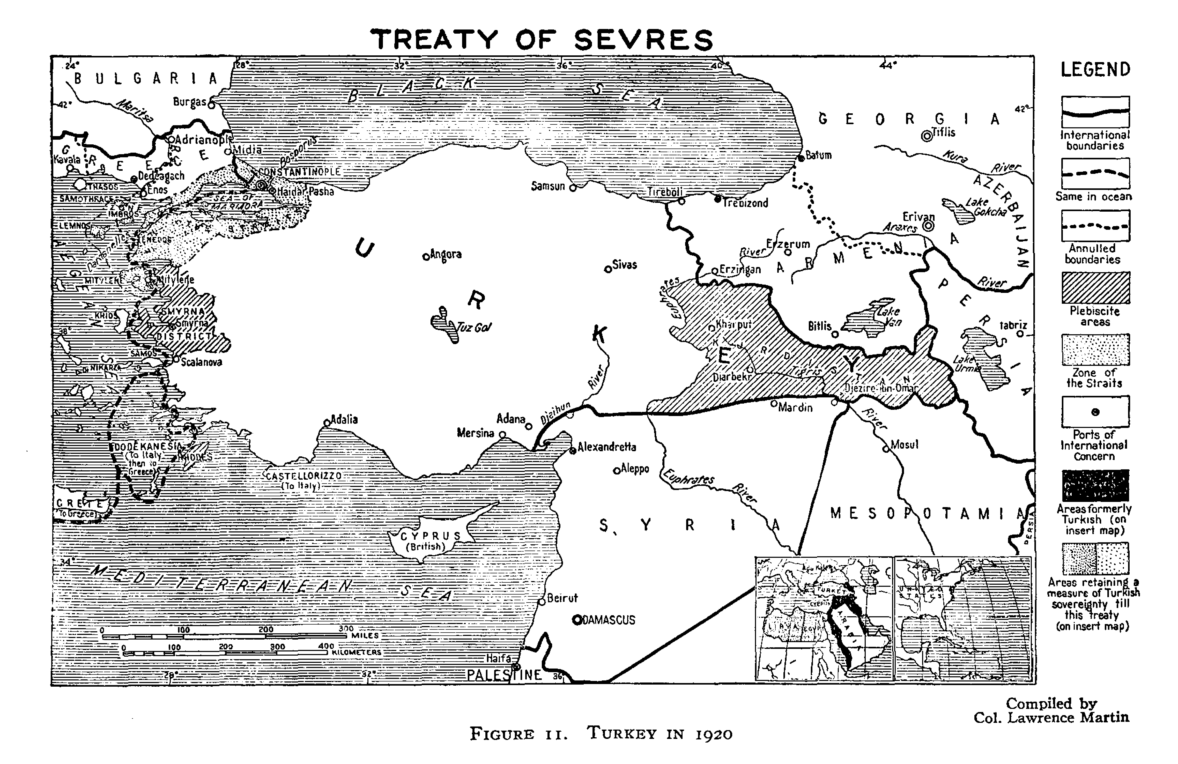
English: An original map from 1920 illustrating the Treaty of Sevres region. |
| Datums | |
| Avots | http://www.gwpda.org/gifs/turk1920.gif |
| Autors | Lt. Colonel Lawrence Martin. Geographer of the Institute of Politics at Williamstown, MA, 1921-27 |
Licence
This media file is in the public domain in the United States. This applies to U.S. works where the copyright has expired, often because its first publication occurred prior to January 1, 1929, and if not then due to lack of notice or renewal. See this page for further explanation.
|
 | |
 |
This image might not be in the public domain outside of the United States; this especially applies in the countries and areas that do not apply the rule of the shorter term for US works, such as Canada, Mainland China (not Hong Kong or Macao), Germany, Mexico, and Switzerland. The creator and year of publication are essential information and must be provided. See Wikipedia:Public domain and Wikipedia:Copyrights for more details.
|
Faila hronoloģija
Uzklikšķini uz datums/laiks kolonnā esošās saites, lai apskatītos, kā šis fails izskatījās tad.
| Datums/Laiks | Attēls | Izmēri | Dalībnieks | Komentārs | |
|---|---|---|---|---|---|
| tagadējais | 2021. gada 30. jūnijs, plkst. 10.23 | | 4 553 × 2 953 (260 KB) | Zero0000 | minor adjustments |
| 2021. gada 30. jūnijs, plkst. 10.07 |  | 2 277 × 1 477 (366 KB) | Zero0000 | Higher resolution | |
| 2012. gada 30. jūnijs, plkst. 21.12 |  | 1 034 × 692 (33 KB) | Infestor |
Faila lietojums
Šo failu izmanto šajā 1 lapā:
Globālais faila lietojums
Šīs Vikipēdijas izmanto šo failu:
- Izmantojums ar.wikipedia.org
- Izmantojums azb.wikipedia.org
- Izmantojums az.wikipedia.org
- Izmantojums cy.wikipedia.org
- Izmantojums el.wikipedia.org
- Izmantojums en.wikipedia.org
- Izmantojums et.wikipedia.org
- Izmantojums he.wikipedia.org
- Izmantojums hy.wikipedia.org
- Izmantojums ia.wikipedia.org
- Izmantojums ja.wikipedia.org
- Izmantojums ko.wikipedia.org
- Izmantojums mk.wikipedia.org
- Izmantojums pnb.wikipedia.org
- Izmantojums ru.wikipedia.org
- Izmantojums tr.wikipedia.org
- Izmantojums uk.wikipedia.org
- Izmantojums ur.wikipedia.org
- Izmantojums www.wikidata.org