
Attēls:Wilder Kaiser, Tirol, Panorama, 160624, ako.jpg

Sākotnējais fails (10 000 × 2 819 pikseļi, faila izmērs: 18,05 MB, MIME tips: image/jpeg)
| Šis fails ir no Vikikrātuves. Tā apraksts no attēla lapas Vikikrātuvē ir parādīts zemāk. Vikikrātuve ir brīvi licencēta failu krātuve. Tu vari tai palīdzēt. |
Kopsavilkums
| Apraksts |
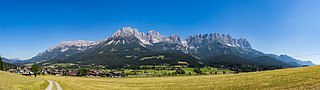
Deutsch: Panorama des Kaisergebirges in Tirol, Ansicht von Süden. Im Vordergrund ist Ellmau zu sehen. English: Panorama of Kaisergebirge, Tyrol, Austria. View from south. In the foreground the town of Ellmau can be seen.
Español: Vista panorámica del macizo Kaisergebirge en los Alpes orientales. En primer plano se puede ver la localidad de Ellmau, Tirol, Austria.
Polski: Panorama od strony południowej pasma górskiego Kaisergebirge w Tyrolu, w Austrii. Na pierwszym planie widoczna jest miejscowość Ellmau.
Čeština: Panorama pohoří Kaisergebirge (Císařské hory) pohledem z jižní strany, Východní Alpy, Tyrolsko, Rakousko. V popředí město Ellmau.
Italiano: Panorama dei monti del Kaiser, Tirolo, Austria, visto da sud. In primo piano di può vedere la città di Ellmau.
Македонски: Поглед на Царските Планини во Тирол, Австрија.
Português: Vista panorâmica do maciço Kaisergebirge nos Alpes Orientais. Em primeiro plano pode-se ver a cidade de Ellmau, Tirol, Áustria.
|
||
| Datums | |||
| Avots | Paša darbs | ||
| Autors | Ansgar Koreng | ||
| Atļauja: (Šī faila izmantošana citur) |
|
||
| Atsauce (required by the license) | Ansgar Koreng / | ||
| Camera location | | View this and other nearby images on: OpenStreetMap |
|---|
| Camera Model | Canon EOS 6D |
|---|---|
| Shutter speed | 1/100s |
| Aperture | f/11 |
| Film speed (ISO) | 100 |
| Lens | Sigma 50mm f/1.4 DG HSM (Art) |
| Focal length | 50mm |
| Support | Manfrotto Befree Tripod with ball head and Nodal Ninja 3 Mk II panorama head |
| Notes | Stitched from 27 pictures (3 rows, 9 columns). |

|
NOTE: This image is a panorama of Kaisergebirge consisting of 27 frames that were merged or stitched in PTGui Pro 10.0.15. As a result, this image necessarily underwent some form of digital manipulation. These manipulations may include blending, blurring, cloning, and colour and perspective adjustments. As a result of these adjustments, the image content may be slightly different from reality at the points where multiple images were combined. This manipulation is often required due to lens, perspective, and parallax distortions.
|
Assessment
|
This image was selected as picture of the day on Wikimedia Commons for 24 June 2018. It was captioned as follows: English: Panorama of Kaisergebirge, Tyrol, Austria. View from south. In the foreground the town of Ellmau can be seen. Other languages:
Čeština: Panorama pohoří Kaisergebirge (Císařské hory) pohledem z jižní strany, Východní Alpy, Tyrolsko, Rakousko. V popředí město Ellmau. Deutsch: Panorama des Kaisergebirges in Tirol, Ansicht von Süden. Im Vordergrund ist Ellmau zu sehen. English: Panorama of Kaisergebirge, Tyrol, Austria. View from south. In the foreground the town of Ellmau can be seen. Español: Vista panorámica del macizo Kaisergebirge en los Alpes orientales. En primer plano se puede ver la localidad de Ellmau, Tirol, Austria. Italiano: Panorama dei monti del Kaiser, Tirolo, Austria, visto da sud. In primo piano di può vedere la città di Ellmau. Polski: Panorama od strony południowej pasma górskiego Kaisergebirge w Tyrolu, w Austrii. Na pierwszym planie widoczna jest miejscowość Ellmau. Português: Vista panorâmica do maciço Kaisergebirge nos Alpes Orientais. Em primeiro plano pode-se ver a cidade de Ellmau, Tirol, Áustria. Македонски: Поглед на Царските Планини во Тирол, Австрија. |
Licence
- Jūs varat brīvi:
- koplietot – kopēt, izplatīt un pārraidīt darbu
- remiksēt – pielāgot darbu
- Saskaņā ar šādiem nosacījumiem:
- atsaucoties – Tev ir jānorāda autors, saite uz licenci un to, vai veiktas kādas izmaiņas. To var darīt jebkādā saprātīgā veidā, bet ne tādā, kas norādītu, ka licencētājs atbalsta tevi vai veidu, kā tu izmanto šo darbu.
- nemainot licenci – Ja tu miksē, pārveido vai izmanto materiālu, tev savs devums jāpublicē ar to pašu vai saderīgu licenci kā oriģināls.
Modifications
|
|
Please do not upload a modified image here without consultation with the Author. The author would like to make corrections only at his own source. This ensures that the changes are preserved. |

Faila hronoloģija
Uzklikšķini uz datums/laiks kolonnā esošās saites, lai apskatītos, kā šis fails izskatījās tad.
| Datums/Laiks | Attēls | Izmēri | Dalībnieks | Komentārs | |
|---|---|---|---|---|---|
| tagadējais | 2016. gada 9. jūlijs, plkst. 11.15 | 10 000 × 2 819 (18,05 MB) | Code | Removed some dust spots. | |
| 2016. gada 1. jūlijs, plkst. 08.21 | 10 000 × 2 819 (14,23 MB) | Code | =={{int:filedesc}}== {{Information |description={{de|1=Panorama des Kaisergebirges in Tirol, Ansicht von Süden. Im Vordergrund ist Ellmau zu sehen.}}{{en|1=Panorama of Kaisergebirge, Tyrol, Austria. View from south. In the foreground the town of Ellma... |
Faila lietojums
Šo failu neizmanto nevienā lapā.
Globālais faila lietojums
Šīs Vikipēdijas izmanto šo failu:
- Izmantojums be-tarask.wikipedia.org
- Izmantojums crh.wikipedia.org
- Izmantojums cv.wikipedia.org
- Izmantojums fa.wikipedia.org
- Izmantojums hu.wikipedia.org
- Izmantojums hy.wikipedia.org
- Izmantojums ka.wikipedia.org
- Izmantojums ko.wikipedia.org
- Izmantojums lbe.wikipedia.org
- Izmantojums lez.wikipedia.org
- Izmantojums mk.wikipedia.org
- Izmantojums os.wikipedia.org
- Izmantojums pt.wikipedia.org
- Izmantojums ru.wikipedia.org
- Izmantojums ru.wikinews.org
- Izmantojums sah.wikipedia.org
- Izmantojums tt.wikipedia.org
- Izmantojums uk.wikipedia.org
- Izmantojums vep.wikipedia.org
- Izmantojums vi.wikipedia.org
- Izmantojums zh.wikipedia.org