
Attēls:Haupthandelsroute Hanse.png

Šī priekšskata izmērs: 785 × 600 pikseļi. Citi izmēri: 314 × 240 pikseļi | 628 × 480 pikseļi | 789 × 603 pikseļi.
Sākotnējais fails (789 × 603 pikseļi, faila izmērs: 127 KB, MIME tips: image/png)
| Šis fails ir no Vikikrātuves. Tā apraksts no attēla lapas Vikikrātuvē ir parādīts zemāk. Vikikrātuve ir brīvi licencēta failu krātuve. Tu vari tai palīdzēt. |

|
This historical map image could be re-created using vector graphics as an SVG file. This has several advantages; see Commons:Media for cleanup for more information. If an SVG form of this image is available, please upload it and afterwards replace this template with
{{vector version available|new image name}}.
It is recommended to name the SVG file “Haupthandelsroute Hanse.svg”—then the template Vector version available (or Vva) does not need the new image name parameter. |
Kopsavilkums
| Apraksts |
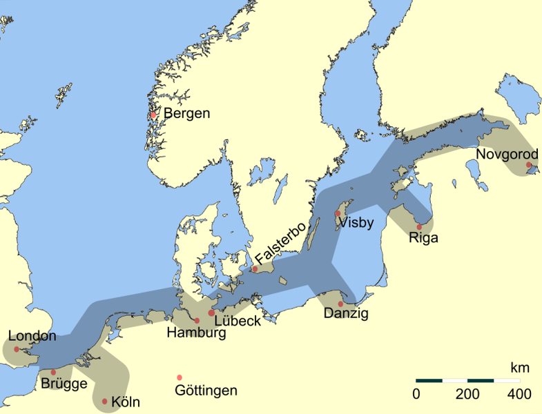
Deutsch: Vereinfachte Darstellung der Haupthandelsroute der Hanse im Nordeuropäischen Raum. Eigene verbesserte Darstellung mit GMT.
English: Main trading routes of the Hanseatic League in northern Europe.
Svenska: Förenklad översikt över Hansans viktigaste handelsvägar i norra Europa. |
| Datums | |
| Avots | Paša darbs |
| Autors | Flo Beck |
| Citas versijas | العربيَّة |
Licence
| I, the copyright holder of this work, release this work into the public domain. This applies worldwide. In some countries this may not be legally possible; if so: I grant anyone the right to use this work for any purpose, without any conditions, unless such conditions are required by law. |
| This work has been released into the public domain by its author, German Wikipedia at vācu Vikipēdija. This applies worldwide. In some countries this may not be legally possible; if so: German Wikipedia grants anyone the right to use this work for any purpose, without any conditions, unless such conditions are required by law. |
Faila hronoloģija
Uzklikšķini uz datums/laiks kolonnā esošās saites, lai apskatītos, kā šis fails izskatījās tad.
| Datums/Laiks | Attēls | Izmēri | Dalībnieks | Komentārs | |
|---|---|---|---|---|---|
| tagadējais | 2022. gada 6. jūnijs, plkst. 16.26 | | 789 × 603 (127 KB) | 野良人 | opt |
| 2012. gada 7. maijs, plkst. 15.30 |  | 789 × 603 (130 KB) | Ras67 | cropped, opt. | |
| 2006. gada 25. marts, plkst. 05.34 |  | 795 × 609 (175 KB) | Flo Beck | Vereinfachte Darstellung der Haupthandelsroute der Hanse im Nordeuropäischen Raum, eigene verbesserte Darstellung mit GMT, erstellt von Flo Beck {{PD-user-de|German Wikipedia|Flo Beck}} |
Faila lietojums
Šo failu izmanto šajā 1 lapā:
Globālais faila lietojums
Šīs Vikipēdijas izmanto šo failu:
- Izmantojums af.wikipedia.org
- Izmantojums an.wikipedia.org
- Izmantojums ar.wikipedia.org
- Izmantojums arz.wikipedia.org
- Izmantojums ast.wikipedia.org
- Izmantojums ban.wikipedia.org
- Izmantojums ba.wikipedia.org
- Izmantojums be.wikipedia.org
- Izmantojums bg.wikipedia.org
- Izmantojums br.wikipedia.org
- Izmantojums bs.wikipedia.org
- Izmantojums ca.wikipedia.org
- Izmantojums csb.wikipedia.org
- Izmantojums cs.wikipedia.org
- Izmantojums cu.wikipedia.org
- Izmantojums cy.wikipedia.org
- Izmantojums da.wikipedia.org
- Izmantojums de.wikipedia.org
Skatīt šī faila pilno globālo izmantojumu.