
Attēls:1918. Карта УНР.jpg

Šī priekšskata izmērs: 800 × 535 pikseļi. Citi izmēri: 320 × 214 pikseļi | 640 × 428 pikseļi | 1 024 × 684 pikseļi | 1 280 × 855 pikseļi | 2 560 × 1 711 pikseļi | 3 104 × 2 074 pikseļi.
Sākotnējais fails (3 104 × 2 074 pikseļi, faila izmērs: 3,16 MB, MIME tips: image/jpeg)
| Šis fails ir no Vikikrātuves. Tā apraksts no attēla lapas Vikikrātuvē ir parādīts zemāk. Vikikrātuve ir brīvi licencēta failu krātuve. Tu vari tai palīdzēt. |
Kopsavilkums
| Apraksts |
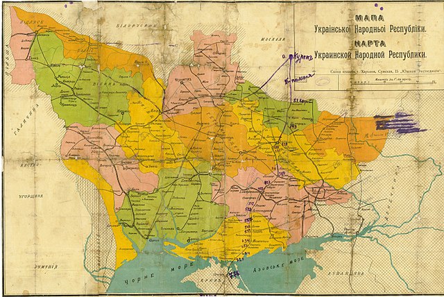
Русский: Карта УНР
Українська: Мапа зберігалася в родинному архіві сім'ї Голубченків у Сумах. У серпні 2005 року сім'я передала карту на зберігання до Державного архіву Сумської області.
English: Map of the UPR. The map was kept in the family archive of the Golubchenko family in Sumy. In August 2005, the family transferred the map to the State Archives of the Sumy Region for safekeeping. |
|||
| Datums | ||||
| Avots | ||||
| Autors |
Русский: Южная экспедиция |
|||
| Atļauja: (Šī faila izmantošana citur) |
|

Faila hronoloģija
Uzklikšķini uz datums/laiks kolonnā esošās saites, lai apskatītos, kā šis fails izskatījās tad.
| Datums/Laiks | Attēls | Izmēri | Dalībnieks | Komentārs | |
|---|---|---|---|---|---|
| tagadējais | 2014. gada 8. aprīlis, plkst. 13.19 | | 3 104 × 2 074 (3,16 MB) | Butko | {{Information |Description={{ru|Карта УНР}} |Source= * http://img-fotki.yandex.ru/get/9809/18675158.6b/0_102b44_19e71493_orig * http://hai-nyzhnyk.in.ua/doc2/map.unr.php |Date=1918 |Author={{ru|Южная экспедиция}} |Permission={{PD... |
Faila lietojums
Šo failu izmanto šajā 1 lapā:
Globālais faila lietojums
Šīs Vikipēdijas izmanto šo failu:
- Izmantojums ar.wikipedia.org
- Izmantojums en.wikipedia.org
- Izmantojums es.wikipedia.org
- Izmantojums it.wikipedia.org
- Izmantojums ru.wikipedia.org
- Украинская Советская Социалистическая Республика
- Раздельная
- Украинская Народная Республика
- Украинская народная республика Советов
- Украинская держава
- Украинская Центральная рада
- Революция и Гражданская война на Украине
- Южный революционный фронт по борьбе с контрреволюцией (1917)
- Бои за Донбасс (январь — май 1919)
- Википедия:К переименованию/8 декабря 2015
- Участник:ASDFS/Черновик
- Википедия:Сообщения об ошибках/Архив/2023/07
- Izmantojums uk.wikipedia.org
- Izmantojums www.wikidata.org