
Attēls:20210529 Lands End-9.jpg

Šī priekšskata izmērs: 800 × 533 pikseļi. Citi izmēri: 320 × 213 pikseļi | 640 × 427 pikseļi | 1 024 × 683 pikseļi | 1 280 × 853 pikseļi | 2 560 × 1 707 pikseļi | 5 760 × 3 840 pikseļi.
Sākotnējais fails (5 760 × 3 840 pikseļi, faila izmērs: 17,63 MB, MIME tips: image/jpeg)
| Šis fails ir no Vikikrātuves. Tā apraksts no attēla lapas Vikikrātuvē ir parādīts zemāk. Vikikrātuve ir brīvi licencēta failu krātuve. Tu vari tai palīdzēt. |
Kopsavilkums
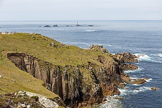
| Apraksts | Land's End, the most westerly point in England, in May 2021. |
| Datums | |
| Avots | Paša darbs |
| Autors | Balon Greyjoy |
| Camera location | | View this and other nearby images on: OpenStreetMap |
|---|
This file was uploaded with VicuñaUploader.
Licence
| This file is made available under the Creative Commons CC0 1.0 Universal Public Domain Dedication. | |
| The person who associated a work with this deed has dedicated the work to the public domain by waiving all of their rights to the work worldwide under copyright law, including all related and neighboring rights, to the extent allowed by law. You can copy, modify, distribute and perform the work, even for commercial purposes, all without asking permission.
|
Faila hronoloģija
Uzklikšķini uz datums/laiks kolonnā esošās saites, lai apskatītos, kā šis fails izskatījās tad.
| Datums/Laiks | Attēls | Izmēri | Dalībnieks | Komentārs | |
|---|---|---|---|---|---|
| tagadējais | 2023. gada 1. jūlijs, plkst. 03.37 | | 5 760 × 3 840 (17,63 MB) | Balon Greyjoy | VicuñaUploader 1.3.3a |
Faila lietojums
Šo failu izmanto šajā 1 lapā:
Globālais faila lietojums
Šīs Vikipēdijas izmanto šo failu:
- Izmantojums de.wikipedia.org
- Izmantojums en.wikipedia.org