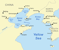
Attēls:Bohaiseamap2.png

Lapas saturs netiek atbalstīts citās valodās.
Vikipēdijas lapa

Bohaiseamap2.png(569 × 487 pikseļi, faila izmērs: 136 KB, MIME tips: image/png)

Warning sign This file requires updating because: I suggest using the more normative 'Pyongyang' and 'Yellow River' or at least adding these forms in parentheses. In doing so, you could add a timestamp to the file.
Please notify the uploader with {{subst:update-note|1=File:Bohaiseamap2.png|2=I suggest using the more normative 'Pyongyang' and 'Yellow River' or at least adding these forms in parentheses.}} ~~~~

Kopsavilkums

Apraksts Map of the Bohai Sea and surrounding bays. For a more general map of the same area see Image:Bohai Sea map.png
Datums
Avots self-made, based on DCW data.
Autors Kmusser
Citas versijas

Derivative works of this file:

This map image could be re-created using vector graphics as an SVG file. This has several advantages; see Commons:Media for cleanup for more information. If an SVG form of this image is available, please upload it and afterwards replace this template with {{vector version available|new image name}}.


It is recommended to name the SVG file “Bohaiseamap2.svg”—then the template Vector version available (or Vva) does not need the new image name parameter.

Licence

Es, šī darba autortiesību īpašnieks, publicēju to saskaņā ar šo licenci:
w:en:Creative Commons
atsaucoties nemainot licenci
Šis fails tiek izplatīts saskaņā ar licences Creative Commons Atsauce-Līdzīgi Noteikumi 2.5 Vispārējiem noteikumiem.
Jūs varat brīvi:
  • koplietot – kopēt, izplatīt un pārraidīt darbu
  • remiksēt – pielāgot darbu
Saskaņā ar šādiem nosacījumiem:
  • atsaucoties – Tev ir jānorāda autors, saite uz licenci un to, vai veiktas kādas izmaiņas. To var darīt jebkādā saprātīgā veidā, bet ne tādā, kas norādītu, ka licencētājs atbalsta tevi vai veidu, kā tu izmanto šo darbu.
  • nemainot licenci – Ja tu miksē, pārveido vai izmanto materiālu, tev savs devums jāpublicē ar to pašu vai saderīgu licenci kā oriģināls.

Captions

Pievieno vienas rindiņas aprakstu, ko šis fails attēlo
Map of the Bohai Sea and surrounding bays

Šajā failā attēlotais

attēlo

27 jūnijs 2007

image/png

checksum angļu

e776fb894d1db142a63c8f0d600c8d6c18de759c

data size angļu

139 100 Baits

487 pikselis

569 pikselis

Faila hronoloģija

Uzklikšķini uz datums/laiks kolonnā esošās saites, lai apskatītos, kā šis fails izskatījās tad.

Datums/LaiksAttēlsIzmēriDalībnieksKomentārs
tagadējais2021. gada 7. janvāris, plkst. 22.332021. gada 7. janvāris, plkst. 22.33 versijas sīktēls569 × 487 (136 KB)Ras67black frame cropped and alpha channel removed
2007. gada 27. jūnijs, plkst. 17.592007. gada 27. jūnijs, plkst. 17.59 versijas sīktēls583 × 500 (179 KB)Kmusseradded strait
2007. gada 27. jūnijs, plkst. 17.502007. gada 27. jūnijs, plkst. 17.50 versijas sīktēls500 × 429 (141 KB)Kmusser{{Information |Description=Map of the Bohai Sea and surrounding bays. For a more general map of the same area see Image:Bohai Sea map.png |Source=self-made, based on DCW data. |Date=June 27, 2007

Šo failu neizmanto nevienā lapā.

Globālais faila lietojums

Šīs Vikipēdijas izmanto šo failu:

Skatīt šī faila pilno globālo izmantojumu.

Metadati