
Attēls:China-Historic macro areas.svg

Sākotnējais fails (SVG fails, definētais izmērs 1 438 × 1 047 pikseļi, faila izmērs: 3,61 MB)
| Šis fails ir no Vikikrātuves. Tā apraksts no attēla lapas Vikikrātuvē ir parādīts zemāk. Vikikrātuve ir brīvi licencēta failu krātuve. Tu vari tai palīdzēt. |
Kopsavilkums
| Apraksts |
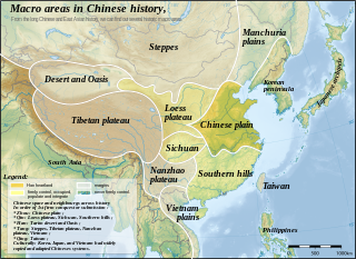
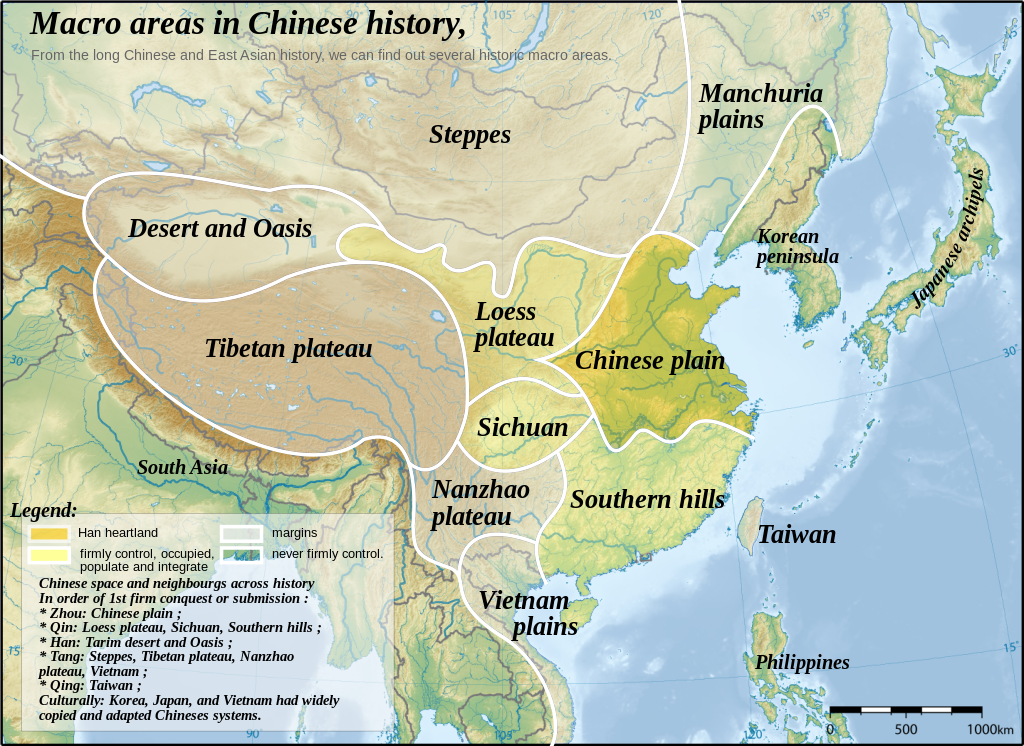
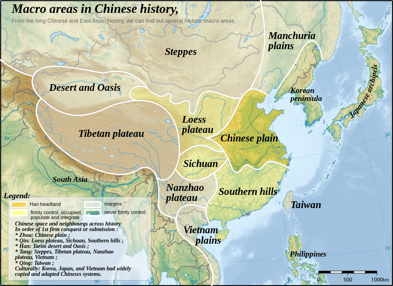
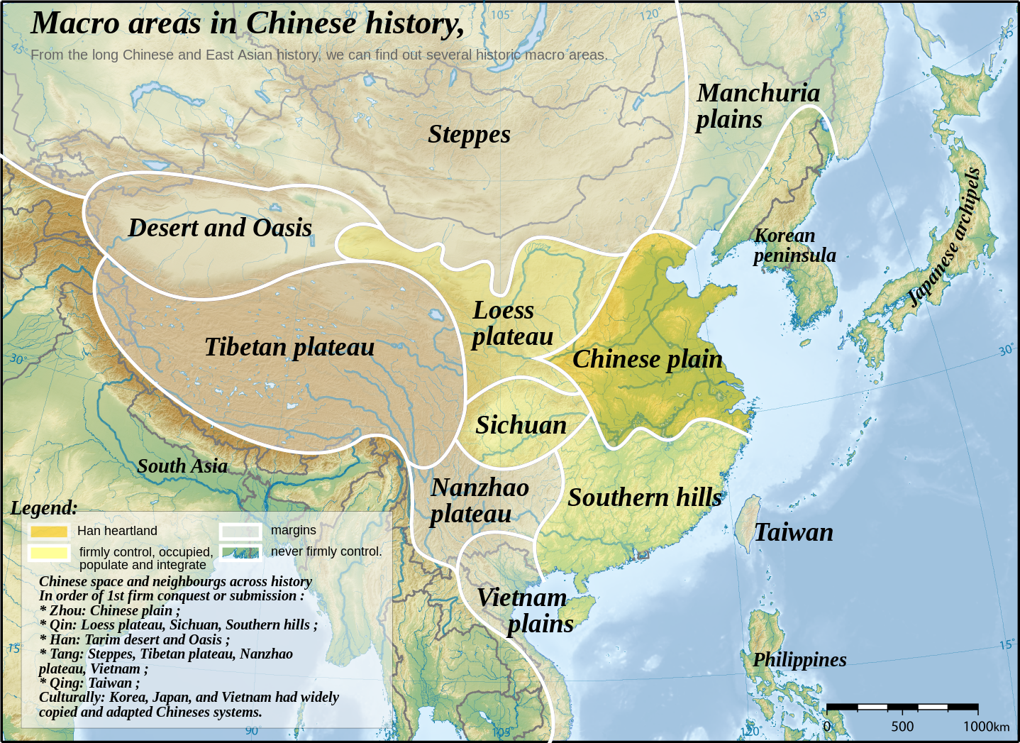
English: Topographic map of East Asia, with historical areas and macro-regions of China depicted.
中文(简体):东亚地形图。
中文(繁體):東亞地形圖。
日本語: 東アジアの地形図。
한국어: 동아시아의 지형도.
Tiếng Việt: Bản đồ địa hình khu vực Đông Á.
Català: Mapa topogràfic de l'Àsia Oriental, amb les macroàrees històriques de la Xina descrites. |
||
| Datums | |||
| Avots | East Asia topographic map.png by Ksiom | ||
| Autors | Yug | ||
| Citas versijas |
File:China-Historic macro areas.svg has 2 translations.
|
||
| SVG veidošana |
|


see also: http://uk.wikipedia.org/wiki/%D0%A4%D0%B0%D0%B9%D0%BB:China-Historic_macro_areas-uk.png
The map has been created with the Generic Mapping Tools: https://www.generic-mapping-tools.org/ using one or more of these public-domain datasets for the relief:
|

|
Ir dota atļauja kopēt, izplatīt un/vai pārveidot šo dokumentu saskaņā ar GNU brīvās dokumentācijas licences, versijas 1.2 vai jebkuras vēlākas versijas, ko publiskojis Brīvās programmatūras fonds nosacījumiem; bez nemainīgajām sadaļā, priekšējā un aizmugurēja'vāka tekstiem. Licences kopija ir iekļauta sadaļā ar nosaukumu GNU brīvās dokumentācijas licence. |
| Šis fails tiek izplatīts saskaņā ar licences Creative Commons Atsauce-Līdzīgi Noteikumi 3.0 Vispārējiem noteikumiem. | ||
| ||
| This licensing tag was added to this file as part of the GFDL licensing update. |

|
This SVG file contains embedded text that can be translated into your language, using any capable SVG editor, text editor or the SVG Translate tool. For more information see: About translating SVG files. |
This file is translated using SVG <switch> elements. All translations are stored in the same file! Learn more.
For most Wikipedia projects, you can embed the file normally (without a To translate the text into your language, you can use the SVG Translate tool. Alternatively, you can download the file to your computer, add your translations using whatever software you're familiar with, and re-upload it with the same name. You will find help in Graphics Lab if you're not sure how to do this. |
Original upload log
This image is a derivative work of the following images:
- East Asia topographic map.png licensed with GFDL-GMT
- 2008-08-17T05:11:19Z Ksiom 2876x2094 (9245630 Bytes) {{Information |Description={{en|1=Topographic map of East Asia.}} {{ko|1=동아시아의 지형도.}} |Source=Own work by uploader |Author=[[User:Ksiom|Ksiom]] |Date=2008-08-17 |Permission={{GFDL-GMT}} |other_versions= }} [
Uploaded with derivativeFX
Faila hronoloģija
Uzklikšķini uz datums/laiks kolonnā esošās saites, lai apskatītos, kā šis fails izskatījās tad.
| Datums/Laiks | Attēls | Izmēri | Dalībnieks | Komentārs | |
|---|---|---|---|---|---|
| tagadējais | 2023. gada 18. septembris, plkst. 16.48 | | 1 438 × 1 047 (3,61 MB) | JoanSMF | File uploaded using svgtranslate tool (https://svgtranslate.toolforge.org/). Added translation for ca. |
| 2023. gada 18. septembris, plkst. 15.50 |  | 1 438 × 1 047 (3,6 MB) | JoanSMF | File uploaded using svgtranslate tool (https://svgtranslate.toolforge.org/). Added translation for ca. | |
| 2008. gada 13. decembris, plkst. 19.19 |  | 1 438 × 1 047 (3,59 MB) | Yug | ||
| 2008. gada 13. decembris, plkst. 19.01 |  | 1 438 × 1 047 (267 KB) | Yug | ||
| 2008. gada 13. decembris, plkst. 14.38 |  | 1 438 × 1 047 (3,58 MB) | Yug | Reverted to version as of 06:33, 12 December 2008 | |
| 2008. gada 13. decembris, plkst. 14.25 |  | 1 438 × 1 047 (249 KB) | Yug | Smaller, to fix wikimedia svg to png convertor's limit. | |
| 2008. gada 12. decembris, plkst. 09.33 |  | 1 438 × 1 047 (3,58 MB) | Yug | Reverted to version as of 23:19, 2 December 2008 | |
| 2008. gada 12. decembris, plkst. 09.30 |  | 2 876 × 2 094 (12,15 MB) | Yug | ||
| 2008. gada 3. decembris, plkst. 02.19 |  | 1 438 × 1 047 (3,58 MB) | Yug | SVG with smaller Bitmap image embeded inside. To ease usage (wiki bitmap generator script need small SVG to work fine). | |
| 2008. gada 30. novembris, plkst. 02.31 |  | 2 876 × 2 094 (12,15 MB) | Yug | {{Information |Description={{en|1=Topographic map of East Asia.}} {{ko|1=동아시아의 지형도.}} |Source=*Image:East_Asia_topographic_map.png |Date=2008-11-29 23:09 (UTC) |Author=*derivative work: ~~~ *Image:East_Asia_topographic_map.png: |
Faila lietojums
Šo failu neizmanto nevienā lapā.
Globālais faila lietojums
Šīs Vikipēdijas izmanto šo failu:
- Izmantojums af.wikipedia.org
- Izmantojums bg.wikipedia.org
- Izmantojums ca.wikipedia.org
- Izmantojums da.wikipedia.org
- Izmantojums en.wikipedia.org
- Izmantojums fa.wikipedia.org
- Izmantojums fr.wikipedia.org
- Izmantojums hy.wikipedia.org
- Izmantojums it.wikipedia.org
- Izmantojums ja.wikipedia.org
- Izmantojums nl.wikipedia.org
- Izmantojums pnb.wikipedia.org
- Izmantojums sl.wikipedia.org