
Attēls:Extent of the Roman Republic and the Roman Empire between 218 BC and 117 AD.png
Šī priekšskata izmērs: 800 × 500 pikseļi. Citi izmēri: 320 × 200 pikseļi | 640 × 400 pikseļi | 1 024 × 640 pikseļi | 1 280 × 800 pikseļi | 2 850 × 1 781 pikseļi.
Sākotnējais fails (2 850 × 1 781 pikseļi, faila izmērs: 3,9 MB, MIME tips: image/png)
| Šis fails ir no Vikikrātuves. Tā apraksts no attēla lapas Vikikrātuvē ir parādīts zemāk. Vikikrātuve ir brīvi licencēta failu krātuve. Tu vari tai palīdzēt. |
Kopsavilkums
| Apraksts |
Asturianu: L'Kinans Empire
nel 133 BC (d'escuru y colloráu).
Català: Expansió de l'Imperi Romà el 218 a.C. (vermell), 133 a.C. (rosa), 44 a.C. (taronja), 14 d.C. (groc), i 117 d.C. (verd).
Cymraeg: Yr Ymerodraeth Rufeinig yn 14 (pob lliw heblaw gwyrdd a llwyd).
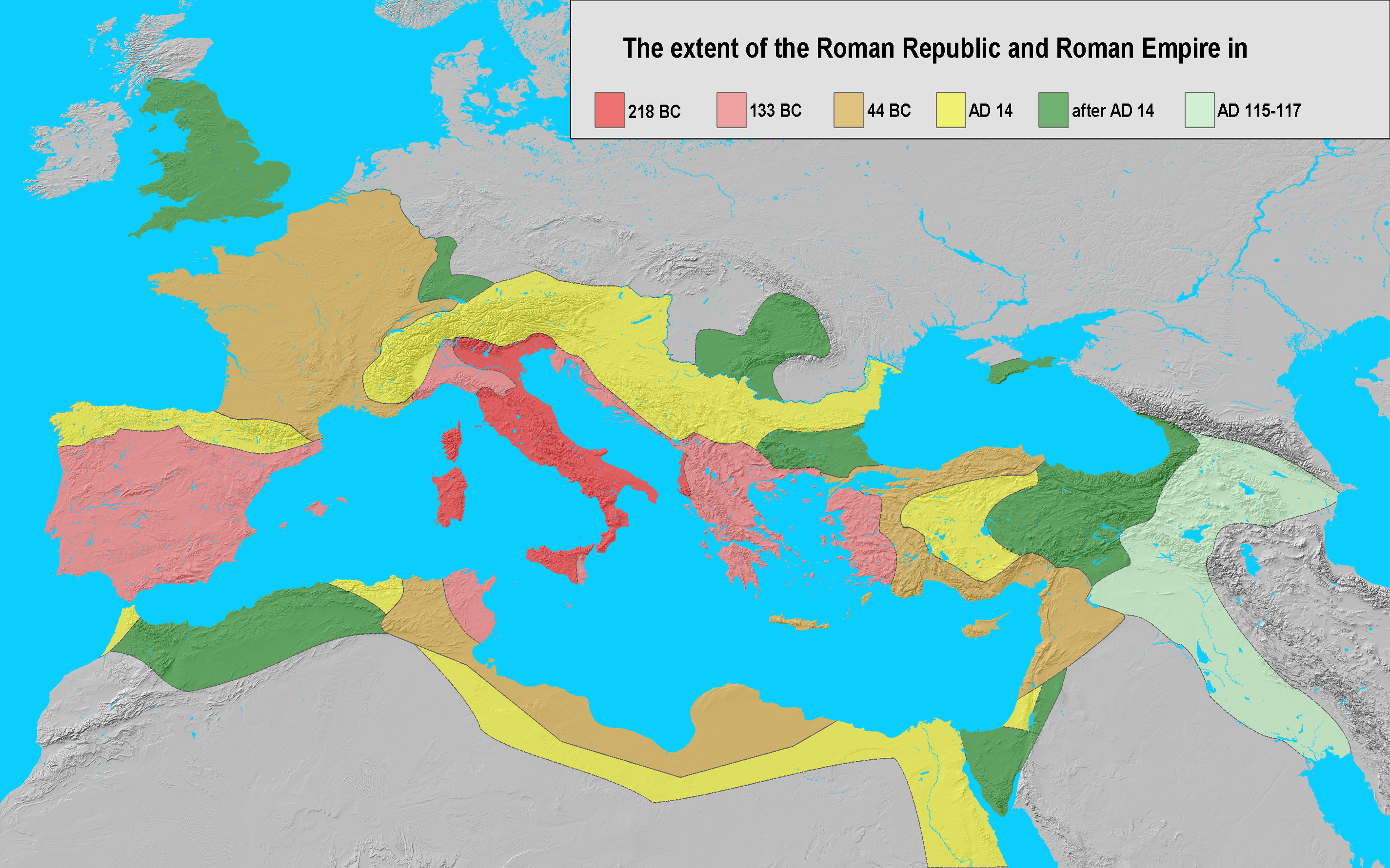
English: Extent of the Roman Republic (509 BC–27 BC) and Roman Empire (27 BC–476/1453 AD) in 218 BC (dark red), 133 BC (light red), 44 BC (orange), 14 AD (yellow), after 14 AD (green) and maximum extension under Trajan 117 (light green).
Español: Expansión del Imperio Romano en 218 (rojo), 133 (rosa), 44 a.C. (naranja), 14 (amarillo), y 117 (verde). Suomi: Rooman valtakunta 44 eaa.
Français : Évolution des territoires contrôlés par l'Empire romain jusqu'à sa chute en 476.
Galego: Expansión do Imperio Romano en 133 a.dC. (vermello), 44 a-dC. (laranxa), 14 (amarelo), e 117 (verde). A extensión da república romana en 218 a. C. (vermello oscuro), 133 a. C. (rosado), 44 a. C. (laranxa), 14 d. C. ( amarelo), despoís 14 d. C. (verde) e unha extensión máxima baixo o gobierno de Trajano, 117 d. C. (verde claro).
客家語/Hak-kâ-ngî:Lò-mâ Ti-koet.
Italiano: Fasi dell'espansionismo romano dal 218 a.C. al 117 d.C..
日本語: 紀元前44年頃のローマ帝国の範囲.
한국어: 로마제국은 북쪽으로는 브리타니아, 남쪽으로는 팔레스타인 지역까지 영토를 확장하였다.
Nederlands: De groei van het Romeinse Rijk tijdens de late republiek en het vroege principaat; ██ 218 v.Chr. (voor de Tweede Punische Oorlog) ██ 133 v.Chr. (begin van onrust in de republiek) ██ 44 v.Chr. (dood van Julius Caesar) ██ 14 v.Chr. (tijdens het principaat van Augustus) ██ uitbreidingen in de eerste eeuw n.Chr. ██ 114-117 n.Chr. (tijdelijke uitbreiding onder Trajanus).
Piemontèis: Surfasse dla Repùblica e dl'Imperi dël 218 aGC (ross ëscur), 133 aGC (reusa), 44 aGC (groson), 14 dGC (giàun), dapress al 14 dGC (vèrd), e surfassa màssima sot a Trajan, 117 dGC (vërzolin).
Русский: Земли Римской Республики (509–27 до н.э.) и Римской Империи (27 до н.э. –476/1453 н.э.) в 218 г. до н.э. (темно красный), 133 г. до н.э. (светло красный), 44 г. до н.э. (оранжевый), 14 г. н.э. (желтый), после 14 г н.э. (зеленый) и достигшие максимума при Траяне в 117 г. н.э. (светло зеленый).
Srpskohrvatski / српскохрватски: Rimska država godine 44. pne. (označeno svjetlocrvenom, tamnocrvenom i narančastom bojom). Rimske teritorije godine 218. pne. (tamnocrveno). Rimska Republika godine 133. pne. (područja označena crveno i svjetlocrveno). Rimsko Carstvo godine 14. n.e. (sve boje osim zelene i sive).
Simple English: The extent of the Roman Republic and Roman Empire in 218 BC (dark red), 133 BC (light red), 44 BC (orange), AD 14 (yellow), after AD 14 (green), and maximum extension under Trajan 117 (light green).
Српски / srpski: Римска република и Римско царство: 215. п. н. е. (тамно црвено),133. п. н. е. (свијетло црвено), 44. п. н. е. (оранж), 14 н. ере (жуто), даља освајања (зелено) и Трајанова освајања на истоку (свијетло зелено).
Svenska: Romerska riket 14 e.Kr. (alla färger utom mörk- och ljusgrönt samt grått). Romerska riket 44 f.Kr. (i mörk- och ljusrött samt oranget). Romerska republiken 218 f.Kr. (i mörkrött). Romerska riket 133 f.Kr. (i mörk- och ljusrött).
தமிழ்: கிமு 44 இல் ரோமன் பேரரசு (கடும், இளம் சிவப்பு மற்றும் செம்மஞ்சள் நிறத்தில் காட்டப்பட்டுள்ளது.). |
| Datums | |
| Avots | own work; base map from Natural Earth |
| Autors | Varana |
| Atļauja: (Šī faila izmantošana citur) |
GDFL, CC-BY-SA |

|
This historical map image could be re-created using vector graphics as an SVG file. This has several advantages; see Commons:Media for cleanup for more information. If an SVG form of this image is available, please upload it and afterwards replace this template with
{{vector version available|new image name}}.
It is recommended to name the SVG file “Extent of the Roman Republic and the Roman Empire between 218 BC and 117 AD.svg”—then the template Vector version available (or Vva) does not need the new image name parameter. |
Licence
Es, šī darba autortiesību īpašnieks, publicēju to saskaņā ar šīm licencēm:

|
Ir dota atļauja kopēt, izplatīt un/vai pārveidot šo dokumentu saskaņā ar GNU brīvās dokumentācijas licences, versijas 1.2 vai jebkuras vēlākas versijas, ko publiskojis Brīvās programmatūras fonds nosacījumiem; bez nemainīgajām sadaļā, priekšējā un aizmugurēja'vāka tekstiem. Licences kopija ir iekļauta sadaļā ar nosaukumu GNU brīvās dokumentācijas licence. |
| Šis fails tiek izplatīts saskaņā ar licences Creative Commons Atsauce-Līdzīgi Noteikumi 3.0 Vispārējiem noteikumiem. | ||
| ||
| This licensing tag was added to this file as part of the GFDL licensing update. |
This file is licensed under the Creative Commons Attribution-Share Alike 2.5 Generic, 2.0 Generic and 1.0 Generic license.
- Jūs varat brīvi:
- koplietot – kopēt, izplatīt un pārraidīt darbu
- remiksēt – pielāgot darbu
- Saskaņā ar šādiem nosacījumiem:
- atsaucoties – Tev ir jānorāda autors, saite uz licenci un to, vai veiktas kādas izmaiņas. To var darīt jebkādā saprātīgā veidā, bet ne tādā, kas norādītu, ka licencētājs atbalsta tevi vai veidu, kā tu izmanto šo darbu.
- nemainot licenci – Ja tu miksē, pārveido vai izmanto materiālu, tev savs devums jāpublicē ar to pašu vai saderīgu licenci kā oriģināls.
Jūs varat izvēlēties licenci pēc jūsu vēlmes.
Faila hronoloģija
Uzklikšķini uz datums/laiks kolonnā esošās saites, lai apskatītos, kā šis fails izskatījās tad.
| Datums/Laiks | Attēls | Izmēri | Dalībnieks | Komentārs | |
|---|---|---|---|---|---|
| tagadējais | 2011. gada 26. oktobris, plkst. 15.01 | | 2 850 × 1 781 (3,9 MB) | Alexander Vigo | Correction in the northwestern Iberian peninsula. The Decimus Junius Brutus Callaicus´ expedition (137 B.C) arrived only to river Miño. |
| 2008. gada 4. janvāris, plkst. 21.35 |  | 2 850 × 1 781 (3,99 MB) | EliasAlucard~commonswiki | corrected aspect ratio | |
| 2006. gada 25. novembris, plkst. 12.21 |  | 2 850 × 1 500 (3,01 MB) | Varana | == Beschreibung == {{Information |Description=Extent of the Roman Empire in 218 BC (dark red), 133 BC (light red), 44 BC (orange), AD 14 (yellow), later acquisitions (green) and Trajan's Eastern conquests (light green). |Source=own work; base map from [ht | |
| 2006. gada 24. novembris, plkst. 22.41 |  | 2 850 × 1 500 (3,01 MB) | Varana | {{Information |Description=Extent of the Roman Empire in 218 BC (dark red), 133 BC (light red), 44 BC (orange), AD 14 (yellow), later acquisitions (green) and Trajan's Eastern conquests (light green). |Source=own work; base map from [http://www.shadedreli |
Faila lietojums
Šo failu izmanto šajā 1 lapā:
Globālais faila lietojums
Šīs Vikipēdijas izmanto šo failu:
- Izmantojums ar.wikipedia.org
- Izmantojums ast.wikipedia.org
- Izmantojums bn.wikipedia.org
- Izmantojums ca.wikipedia.org
- Izmantojums cs.wikipedia.org
- Izmantojums cy.wikipedia.org
- Izmantojums de.wikipedia.org
- Izmantojums en.wikipedia.org
- Izmantojums es.wikipedia.org
- Izmantojums et.wikipedia.org
- Izmantojums eu.wikipedia.org
- Izmantojums fi.wikipedia.org
- Izmantojums fr.wikipedia.org
- Izmantojums gl.wikipedia.org
- Izmantojums hak.wikipedia.org
- Izmantojums he.wikipedia.org
- Izmantojums hy.wikipedia.org
- Izmantojums id.wikipedia.org
- Izmantojums it.wikipedia.org
- Izmantojums ja.wikipedia.org
- Izmantojums ko.wikipedia.org
- Izmantojums ms.wikipedia.org
- Izmantojums nl.wikipedia.org
- Izmantojums nl.wikibooks.org
- Izmantojums no.wikipedia.org
- Izmantojums pms.wikipedia.org
- Izmantojums pnb.wikipedia.org
- Izmantojums ru.wikipedia.org
Skatīt šī faila pilno globālo izmantojumu.