
Attēls:Flag of Bosnia and Herzegovina (construction sheet).svg

Sākotnējais fails (SVG fails, definētais izmērs 1 290 × 690 pikseļi, faila izmērs: 16 KB)
| Šis fails ir no Vikikrātuves. Tā apraksts no attēla lapas Vikikrātuvē ir parādīts zemāk. Vikikrātuve ir brīvi licencēta failu krātuve. Tu vari tai palīdzēt. |
.svg?uselang=lv)
Kopsavilkums
| Apraksts |
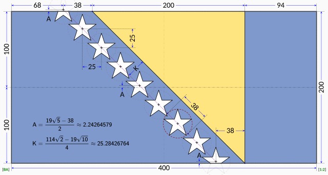
English: Flag of Bosnia and Herzegovina — construction sheet |
| Datums | |
| Avots |
Paša darbs. This construction sheet is derived from multiple sources:
The specification drawing provides:
The triangle is isosceles with one edge running at 45° relative to the edges of the flag. According to the law, the stars are supposed to parallel to the triangle's edge, so it stands that the line of stars must run in a precise 45° line. The law does not explicitly dictate the precise placement of the stars. Close examination of the government EPS drawing reveals most of the intended geometry:
The only missing information is the precise horizontal positioning of the line of stars. Based on measurements from the government EPS drawing, the vertical centerline of the centre star is located at distance from the hoist that is roughly 42.4% of the length of the flag. The centre star was chosen for the measurement because the line of stars in the EPS drawing runs at about 45.5° instead of the 45° dictated by the law. The same measurement repeated on the specification drawing reveals a distance of about 41.8% of the length of the flag with the line of stars again at 45.5°. For the purpose of this Wikimedia construction sheet, the distance from the hoist to the vertical centerline of the centre star is assumed to be exactly 42.0% of the length of the flag. All the other stars are laid out with equal spacing on a precise 45° degree line. Vertical coordinates of the stars are controlled by the intersections of the top and bottom stars with the flag edges. |
| Autors | MapGrid |
Licence

|
This image shows a flag, a coat of arms, a seal or some other official insignia. The use of such symbols is restricted in many countries. These restrictions are independent of the copyright status. |
| I, the copyright holder of this work, release this work into the public domain. This applies worldwide. In some countries this may not be legally possible; if so: I grant anyone the right to use this work for any purpose, without any conditions, unless such conditions are required by law. |
Faila hronoloģija
Uzklikšķini uz datums/laiks kolonnā esošās saites, lai apskatītos, kā šis fails izskatījās tad.
| Datums/Laiks | Attēls | Izmēri | Dalībnieks | Komentārs | |
|---|---|---|---|---|---|
| tagadējais | 2023. gada 17. janvāris, plkst. 16.58 | | 1 290 × 690 (16 KB) | MapGrid | Reverted to version as of 13:48, 17 January 2023 (UTC) |
| 2023. gada 17. janvāris, plkst. 16.51 |  | 1 290 × 690 (16 KB) | MapGrid | ... slightly darker vertical centerline. | |
| 2023. gada 17. janvāris, plkst. 16.48 |  | 1 290 × 690 (16 KB) | MapGrid | Added an opaque background. Added vertical centerline. No change to flag geometry. | |
| 2022. gada 23. janvāris, plkst. 19.00 |  | 1 290 × 690 (16 KB) | MapGrid | Uploaded own work with UploadWizard |
Faila lietojums
Šo failu neizmanto nevienā lapā.
Globālais faila lietojums
Šīs Vikipēdijas izmanto šo failu:
- Izmantojums af.wikipedia.org
- Izmantojums cs.wikipedia.org
- Izmantojums en.wikipedia.org
- Izmantojums hr.wikipedia.org
- Izmantojums nl.wikipedia.org
- Izmantojums uk.wikipedia.org
- Izmantojums zh.wikipedia.org
.svg)