
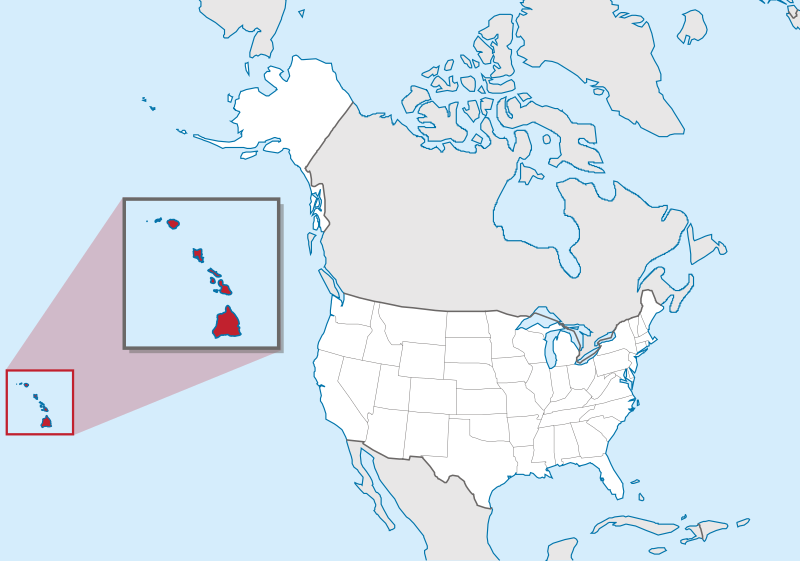
Attēls:Hawaii in United States (zoom) (US50) (-grid).svg

Size of this PNG preview of this SVG file: 800 × 561 pikseļi. Citi izmēri: 320 × 224 pikseļi | 640 × 449 pikseļi | 1 024 × 718 pikseļi | 1 280 × 897 pikseļi | 2 560 × 1 795 pikseļi | 2 078 × 1 457 pikseļi.
Sākotnējais fails (SVG fails, definētais izmērs 2 078 × 1 457 pikseļi, faila izmērs: 256 KB)
| Šis fails ir no Vikikrātuves. Tā apraksts no attēla lapas Vikikrātuvē ir parādīts zemāk. Vikikrātuve ir brīvi licencēta failu krātuve. Tu vari tai palīdzēt. |
Kopsavilkums
.svg)
.svg)
.svg)
.svg)
.svg)
.svg)
.svg)

-en.svg)

.svg)
.svg)
.svg)

_(US48).svg)
_(small_islands_magnified)_(-mini_map_-rivers).svg)
.svg)
_(extra_close)_(US48).svg)
.svg)
_(zoom).svg)

.svg)


_(UNMIK).svg)
.svg)
_(disputed_hatched).svg)
_(claimed_and_disputed_hatched).svg)
.svg)
.svg)
_(%2Ball_claims_hatched).svg)

.svg)
_(shade).svg)
_(shade)_(special_marker).svg)
_(-mini_map).svg)
_(-mini_map).svg)
_(-mini_map).svg)


.svg)

.svg)
_(US50)_(-grid).svg?uselang=lv)
Licence
This image is in the public domain in the United States because it only contains materials that originally came from the United States Geological Survey, an agency of the United States Department of the Interior. For more information, see the official USGS copyright policy.
|

|
I'd greatly appreciate, that you attribute this media file to Wikimedia Commons, if used outside Wikipedia or Commons. For use in publications such as books, newspapers, blogs, websites, please insert here the following line:
|
_(US50)_(-grid).svg&action=edit&redlink=1)
Faila hronoloģija
Uzklikšķini uz datums/laiks kolonnā esošās saites, lai apskatītos, kā šis fails izskatījās tad.
| Datums/Laiks | Attēls | Izmēri | Dalībnieks | Komentārs | |
|---|---|---|---|---|---|
| tagadējais | 2012. gada 20. marts, plkst. 21.11 | | 2 078 × 1 457 (256 KB) | TUBS | corr alabama colors |
| 2011. gada 31. jūlijs, plkst. 00.00 |  | 2 078 × 1 457 (395 KB) | TUBS | == {{int:filedesc}} == {{Information |Description={{de|Lage von XY (siehe Dateiname) in den Vereinigten Staaten.}} {{en|Location of state of XY (see filename) in the United States}} |Source={{own}}{{Adobe |
Faila lietojums
Šo failu izmanto šajās 3 lapās:
Globālais faila lietojums
Šīs Vikipēdijas izmanto šo failu:
- Izmantojums az.wiktionary.org
- Izmantojums bg.wikipedia.org
- Izmantojums bh.wikipedia.org
- Izmantojums bs.wikipedia.org
- Izmantojums bxr.wikipedia.org
- Izmantojums ca.wikipedia.org
- Izmantojums cdo.wikipedia.org
- Izmantojums ceb.wikipedia.org
- Izmantojums ce.wikipedia.org
- Izmantojums chr.wikipedia.org
- Izmantojums cs.wikipedia.org
- Izmantojums da.wikipedia.org
- Izmantojums de.wikipedia.org
- Izmantojums eml.wikipedia.org
- Izmantojums en.wikipedia.org
- List of people from Hawaii
- List of Hawaii state symbols
- List of active separatist movements in Oceania
- Wikipedia talk:Graphics Lab/Illustration workshop/Archive 3
- Callistosporium vinosobrunneum
- Marasmiellus hapuuarum
- Marasmius koae
- Mycena marasmielloides
- Pleurocybella ohiae
- Environmental issues in Hawaii
- Paleontology in Hawaii
- Wikipedia talk:WikiProject Maps/Archive 2013
- Wikipedia talk:Graphics Lab/Archive 4
- Wikipedia:Graphics Lab/Map workshop/Archive/Dec 2015
- File talk:Hawaii in United States (zoom) (US50) (-grid).svg
- Izmantojums en.wikinews.org
- Izmantojums en.wiktionary.org
- Izmantojums eo.wikipedia.org
- Izmantojums fa.wikipedia.org
- Izmantojums fi.wikipedia.org
- Izmantojums fi.wikiquote.org
- Izmantojums fr.wikipedia.org
_(US50)_(-grid).svg)
Skatīt šī faila pilno globālo izmantojumu.
_(US50)_(-grid).svg)
_(US50)_(-grid).svg)