
Attēls:India population density map en.svg

Sākotnējais fails (SVG fails, definētais izmērs 1 639 × 1 852 pikseļi, faila izmērs: 1,23 MB)
| Šis fails ir no Vikikrātuves. Tā apraksts no attēla lapas Vikikrātuvē ir parādīts zemāk. Vikikrātuve ir brīvi licencēta failu krātuve. Tu vari tai palīdzēt. |
| Nosaukums |
India population density map (english) |
|||||||||
| Apraksts |
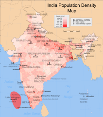
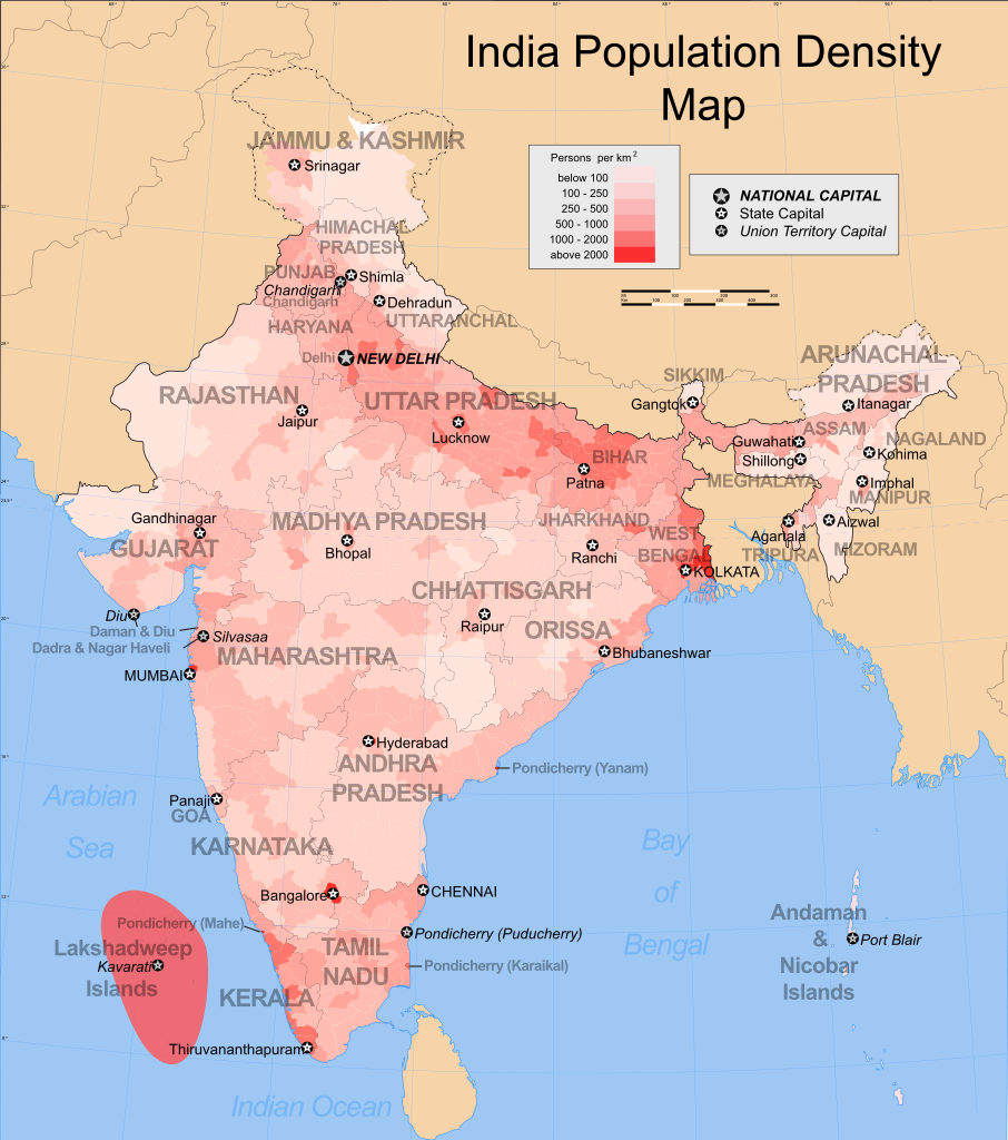
Map showing the population density of each district in India. Based on 2001 census. |
|||||||||
| Map legend |
 |
|||||||||
| Datums | ||||||||||
| Avots |
Paša darbs |
|||||||||
| Izveidotājs |
|
|||||||||
| Atļauja: (Šī faila izmantošana citur) |
Es, šī darba autortiesību īpašnieks, publicēju to saskaņā ar šo licenci: Šis fails tiek izplatīts saskaņā ar licences Creative Commons Atsauce-Līdzīgi Noteikumi 3.0 Vispārējiem noteikumiem.
|
|||||||||
| Geotemporal data | ||||||||||
| Attēlotais datums | second half of 20 century un 21 century | |||||||||
| Spatial reference system | conic | |||||||||
| Bounding box |
|
|||||||||
| Georeferencing | If inappropriate please set warp_status = skip to hide. | |||||||||
| Archival data | ||||||||||
| Piezīmes | Part of WikiProject India Maps | |||||||||

Notes
Depiction of India's borders
- The territorial boundaries of India are shown as per the actual ground situation in accordance with international practices followed by the United Nations ([1], [2]) and the National Geographic Society ([3], [4])
- This map is meant to be for illustrative purpose only and is not authenticated by official government sources. Please check the list of sources and references used to create the map for a measure of accuracy and verifiability.
- The usage of these maps in India, Pakistan and China are governed by different laws that restrict depictions of boundaries other than what is officially recognized by the state. Please check local laws and modify the map accordingly before use.
Explanation of disputed boundaries


- Boundary of Indian claim : The territory India claims is legally theirs, but the claim is disputed by China and Pakistan.
- Line of Control/Line of Conflict : The de facto administrative boundary recognised by the international community. This UN ceasefire line is considered as a temporary solution to an ongoing conflict since the departure of the British Raj.
Borders of disputed regions
The depicted extent of the former territory of the British Indian Empire, succeeded by Republic of India, may not be accepted by few countries as legal due to ongoing border disputes:
- The northern Himalayan region of the disputed territory Indian-administered Kashmir is claimed by India including (Pakistan-administered Kashmir) and the Chinese-occupied territory of (Ladakh plateau). Since 1972, it is divided between all three countries. See also Line of Control and Line of Actual Control.
- Siachen glacier (shown white) is an actively contested region between India and Pakistan. Since 1984, the region is under Indian control.
- The northeastern territory of Arunachal Pradesh is almost entirely claimed by China as part of its Tibetan territory.
- Minor areas of eastern Kashmir's Ladakh division, Himachal Pradesh and Uttarakhand on the Chinese frontier are claimed by China. These areas are under Indian control.
- A small area of Uttarakhand adjoining the Nepal border along the Sarda river is disputed between the two countries.
For a detailed map of all disputed regions in South Asia, see Image:India disputed areas map.svg
Internal borders
The borders of the state of Meghalaya, Assam and Arunachal Pradesh are shown as interpreted from the North-Eastern Areas (Reorganisation) Act, 1971, but has yet to be verified.
Territorial waters
The limit of the territorial waters of India extends to twelve nautical miles measured from the appropriate baseline. See this for more information.
derivative works
Derivative works of this file:
Faila hronoloģija
Uzklikšķini uz datums/laiks kolonnā esošās saites, lai apskatītos, kā šis fails izskatījās tad.
| Datums/Laiks | Attēls | Izmēri | Dalībnieks | Komentārs | |
|---|---|---|---|---|---|
| tagadējais | 2009. gada 24. augusts, plkst. 06.12 | | 1 639 × 1 852 (1,23 MB) | Quibik | Made SVG valid. Converted text to paths for correct display. |
| 2008. gada 27. novembris, plkst. 06.33 |  | 1 639 × 1 852 (873 KB) | Indianhilbilly | Reverted to version as of 10:10, 18 October 2006, readded original map so that the thumbnail is informative | |
| 2008. gada 25. novembris, plkst. 19.00 |  | 1 639 × 1 852 (1,16 MB) | Planemad | added cities and corrected errors | |
| 2006. gada 18. oktobris, plkst. 13.10 |  | 1 639 × 1 852 (873 KB) | Planemad | {{WikiProject_India_Maps |Title=India population density map (english) |Description=Map showing the population density of each district in India. Based on 2001 census. |Source=India Map site[http://www.censusindiamaps.net Census] - [http://www.censusindia |
Faila lietojums
Šo failu izmanto šajā 1 lapā:
Globālais faila lietojums
Šīs Vikipēdijas izmanto šo failu:
- Izmantojums ar.wikipedia.org
- Izmantojums be.wikipedia.org
- Izmantojums bg.wikipedia.org
- Izmantojums bn.wikipedia.org
- Izmantojums ca.wikipedia.org
- Izmantojums ce.wikipedia.org
- Izmantojums cs.wikipedia.org
- Izmantojums dv.wikipedia.org
- Izmantojums dz.wikipedia.org
- Izmantojums el.wikipedia.org
- Izmantojums en.wikipedia.org
- List of states and union territories of India by population
- Talk:India/Archive 4
- Portal:India/Selected picture candidates/Archived nominations
- Talk:India/Archive 11
- Portal:India/Selected picture candidates/India population density map
- Talk:India/Demographics
- List of states in India by past population
- Registrar General and Census Commissioner of India
- Template:Portal/doc/all
- Wikipedia:Userboxes/WikiProjects/Cities
- Wikipedia:WikiProject India/Templates
- Izmantojums es.wikipedia.org
- Izmantojums fi.wikipedia.org
- Izmantojums fr.wikipedia.org
- Izmantojums fy.wikipedia.org
- Izmantojums ga.wikipedia.org
- Izmantojums gl.wikipedia.org
- Izmantojums he.wikipedia.org
- Izmantojums hi.wikipedia.org
- Izmantojums hu.wikipedia.org
- Izmantojums hy.wikipedia.org
- Izmantojums io.wikipedia.org
- Izmantojums ka.wikipedia.org
- Izmantojums kk.wikipedia.org
- Izmantojums kn.wikipedia.org
- Izmantojums mn.wikipedia.org
- Izmantojums mr.wikipedia.org
- Izmantojums nds-nl.wikipedia.org
- Izmantojums nn.wikipedia.org
- Izmantojums no.wikipedia.org
- Izmantojums pl.wikipedia.org
- Izmantojums pnb.wikipedia.org
Skatīt šī faila pilno globālo izmantojumu.