
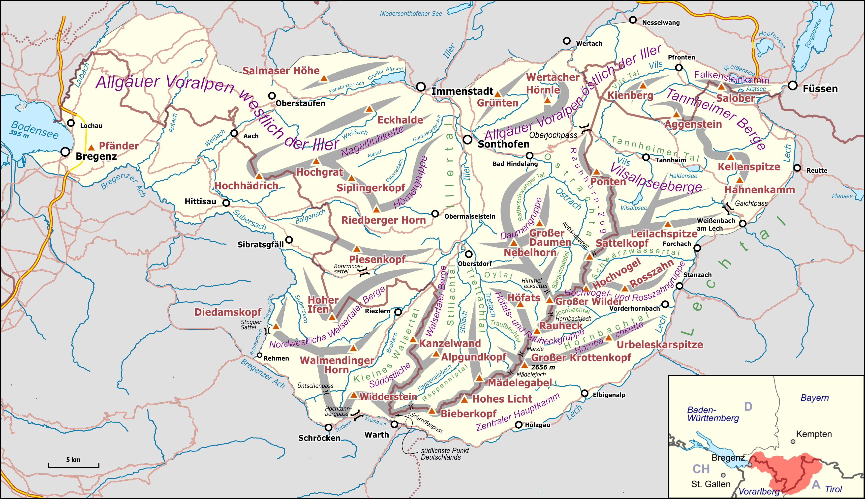
Attēls:Karte Allgäuer Alpen.png
Šī priekšskata izmērs: 800 × 462 pikseļi. Citi izmēri: 320 × 185 pikseļi | 640 × 369 pikseļi | 1 024 × 591 pikseļi | 1 280 × 739 pikseļi | 3 488 × 2 013 pikseļi.
Sākotnējais fails (3 488 × 2 013 pikseļi, faila izmērs: 2,61 MB, MIME tips: image/png)
| Šis fails ir no Vikikrātuves. Tā apraksts no attēla lapas Vikikrātuvē ir parādīts zemāk. Vikikrātuve ir brīvi licencēta failu krātuve. Tu vari tai palīdzēt. |
| Apraksts |
|
|||||||||
| Datums | ||||||||||
| Avots |
Paša darbs Map was created using:
|
|||||||||
| Izveidotājs |
|
|||||||||
| Atļauja: (Šī faila izmantošana citur) |
Map data (c) OpenStreetMap (and) contributors, CC-BY-SA | |||||||||
| Geotemporal data | ||||||||||
| Bounding box |
|
|||||||||
| Georeferencing | ||||||||||
| This work is licensed under the Open Database License (summary). |
Šis fails tiek izplatīts saskaņā ar licences Creative Commons Atsauce-Līdzīgi Noteikumi 3.0 Vispārējiem noteikumiem.
- Jūs varat brīvi:
- koplietot – kopēt, izplatīt un pārraidīt darbu
- remiksēt – pielāgot darbu
- Saskaņā ar šādiem nosacījumiem:
- atsaucoties – Tev ir jānorāda autors, saite uz licenci un to, vai veiktas kādas izmaiņas. To var darīt jebkādā saprātīgā veidā, bet ne tādā, kas norādītu, ka licencētājs atbalsta tevi vai veidu, kā tu izmanto šo darbu.
- nemainot licenci – Ja tu miksē, pārveido vai izmanto materiālu, tev savs devums jāpublicē ar to pašu vai saderīgu licenci kā oriģināls.
Faila hronoloģija
Uzklikšķini uz datums/laiks kolonnā esošās saites, lai apskatītos, kā šis fails izskatījās tad.
| Datums/Laiks | Attēls | Izmēri | Dalībnieks | Komentārs | |
|---|---|---|---|---|---|
| tagadējais | 2017. gada 22. oktobris, plkst. 22.28 | | 3 488 × 2 013 (2,61 MB) | Pechristener | Höhe Krottenkopf korr |
| 2017. gada 22. oktobris, plkst. 18.14 |  | 3 488 × 2 013 (2,61 MB) | Pechristener | {{Map |Description={{de|1=Übersichtskarte des {{w|Allgäuer Alpen||de}}. }} |Source ={{own}} Map was created using: *[http://www.openstreetmap.org/ Open Street Map] *{{w|Germany location map.svg}} for location map |Author = *Haupt... |
Faila lietojums
Šo failu izmanto šajā 1 lapā:
Globālais faila lietojums
Šīs Vikipēdijas izmanto šo failu:
- Izmantojums ca.wikipedia.org
- Izmantojums de.wikipedia.org
- Allgäu
- Allgäuer Alpen
- Pfänder
- Waltenbergerhaus
- Hoher Ifen
- Großer Krottenkopf
- Haldenwanger Eck
- Kreuzeck (Allgäuer Alpen)
- Seealpsee (Allgäuer Alpen)
- Liste der Gebirgsgruppen in den Ostalpen (nach AVE)
- Rote Spitze (Allgäuer Alpen)
- Vorlage:Positionskarte Allgäuer Alpen
- Kienberg (Allgäuer Alpen)
- Benutzer Diskussion:Pechristener/Alpenkarten
- Alpe Gelchenwang
- Imberg (Allgäuer Alpen)
- Rickenbach (Leiblach)
- Izmantojums eo.wikipedia.org
- Izmantojums es.wikipedia.org
- Izmantojums fr.wikipedia.org
- Izmantojums it.wikipedia.org
- Izmantojums pl.wikivoyage.org
- Izmantojums sl.wikipedia.org
- Izmantojums uk.wikipedia.org
- Izmantojums www.wikidata.org