
Attēls:Kayseri districts.png

Šī priekšskata izmērs: 729 × 600 pikseļi. Citi izmēri: 292 × 240 pikseļi | 583 × 480 pikseļi | 999 × 822 pikseļi.
Sākotnējais fails (999 × 822 pikseļi, faila izmērs: 51 KB, MIME tips: image/png)
| Šis fails ir no Vikikrātuves. Tā apraksts no attēla lapas Vikikrātuvē ir parādīts zemāk. Vikikrātuve ir brīvi licencēta failu krātuve. Tu vari tai palīdzēt. |
Kopsavilkums
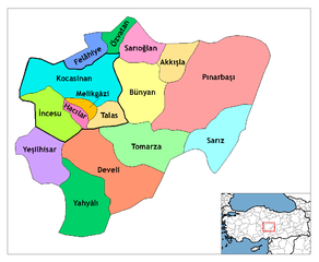
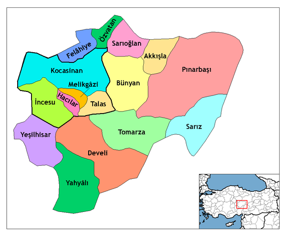
| Apraksts | Map of the districts of Kayseri province in Turkey. Created by Rarelibra 21:59, 1 December 2006 (UTC) for public domain use, using MapInfo Professional v8.5 and various mapping resources. Edited by One Homo Sapiens Corrected text where İ, Ş, ı, ğ, or ş occurs in name. Source: [statoids-com]. Increased font size and enhanced color differences among adjacent districts. User:Sae1962 Marked the boundaries of the provincial centre, the city of Kayseri, with bold lines. |
| Datums | 2006. gada 1. decembris (original upload date) |
| Avots | No machine-readable source provided. Own work assumed (based on copyright claims). |
| Autors | No machine-readable author provided. Rarelibra assumed (based on copyright claims). |
Licence
| I, the copyright holder of this work, release this work into the public domain. This applies worldwide. In some countries this may not be legally possible; if so: I grant anyone the right to use this work for any purpose, without any conditions, unless such conditions are required by law. |
Faila hronoloģija
Uzklikšķini uz datums/laiks kolonnā esošās saites, lai apskatītos, kā šis fails izskatījās tad.
| Datums/Laiks | Attēls | Izmēri | Dalībnieks | Komentārs | |
|---|---|---|---|---|---|
| tagadējais | 2009. gada 30. jūlijs, plkst. 14.25 | | 999 × 822 (51 KB) | Sae1962 | {{Information |Description=Map of the districts of Kayseri province in Turkey. Created by Rarelibra 21:59, 1 December 2006 (UTC) for public domain use, using MapInfo Professional v8.5 and various mapping resources. Edited by [[User:One |
| 2009. gada 4. maijs, plkst. 11.24 |  | 999 × 822 (50 KB) | Sae1962 | Added long vowels for better reading. | |
| 2008. gada 29. decembris, plkst. 02.54 |  | 1 056 × 816 (35 KB) | One Homo Sapiens | Corrected text where İ,Ş,ı,ğ,or ş occurs in name. Source: [statoids-com]. Increased font size and enhanced color differences among adjacent districts. | |
| 2006. gada 2. decembris, plkst. 00.59 |  | 1 056 × 816 (33 KB) | Rarelibra | Map of the districts of Kayseri province in Turkey. Created by ~~~~ for public domain use, using MapInfo Professional v8.5 and various mapping resources. |
Faila lietojums
Šo failu izmanto šajā 1 lapā:
Globālais faila lietojums
Šīs Vikipēdijas izmanto šo failu:
- Izmantojums ast.wikipedia.org
- Izmantojums az.wikipedia.org
- Izmantojums be.wikipedia.org
- Izmantojums ca.wikipedia.org
- Izmantojums cs.wikipedia.org
- Izmantojums de.wikipedia.org
- Kayseri
- Talas (Kayseri)
- Yahyalı
- Hacılar (Kayseri)
- Talas (Bezirk)
- Tomarza
- Wikipedia:Kartenwerkstatt/Archiv/2011-01
- Wikipedia:Kartenwerkstatt/Archiv/2011-05
- Develi (Kayseri)
- Vorlage:Navigationsleiste Landkreise der Provinz Kayseri
- Akkışla
- Bünyan
- Felahiye
- İncesu (Kayseri)
- Kocasinan
- Melikgazi
- Özvatan
- Pınarbaşı (Kayseri)
- Sarıoğlan
- Sarız
- Yeşilhisar (Kayseri)
- Izmantojums diq.wikipedia.org
- Izmantojums en.wikipedia.org
Skatīt šī faila pilno globālo izmantojumu.