
Attēls:Map at millstaetter see.svg

Size of this PNG preview of this SVG file: 800 × 453 pikseļi. Citi izmēri: 320 × 181 pikseļi | 640 × 363 pikseļi | 1 024 × 580 pikseļi | 1 280 × 725 pikseļi | 2 560 × 1 451 pikseļi | 1 313 × 744 pikseļi.
Sākotnējais fails (SVG fails, definētais izmērs 1 313 × 744 pikseļi, faila izmērs: 124 KB)
| Šis fails ir no Vikikrātuves. Tā apraksts no attēla lapas Vikikrātuvē ir parādīts zemāk. Vikikrātuve ir brīvi licencēta failu krātuve. Tu vari tai palīdzēt. |
| Apraksts |
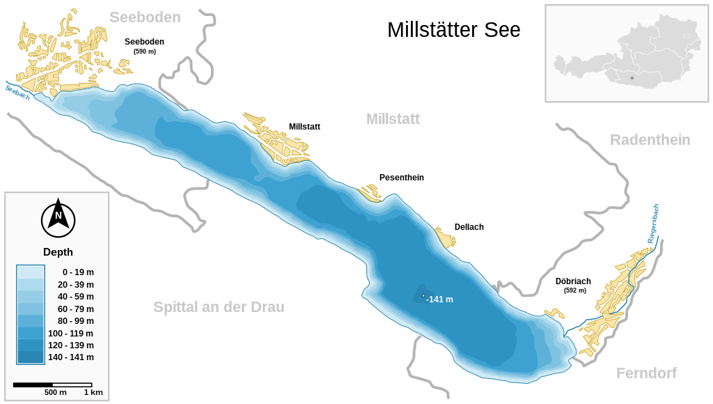
Deutsch: Millstätter See (Kärnten, Österreich) und wichtigste Ortschaften Seeboden / Millstatt / Pesenthein / Dellach / Döbriach
English: Millstätter See (Carinthia, Austria) with surrounding towns.
Français : Carte du lac Millstätter (Carinthie, Autriche) et des villes qui l'entourent. |
| Datums | |
| Avots | |
| Autors | Michael Glanznig (Mglanznig) |
| Atļauja: (Šī faila izmantošana citur) |
Creative Commons Attribution ShareAlike 2.0 Austria |
| Citas versijas | png |
| SVG veidošana | This map is translated using SVG switch elements: all translations are stored in the same file. |
| Camera location | | View this and other nearby images on: OpenStreetMap |
|---|
|

This image was selected as picture of the day on Wikimedia Commons for 4 August 2006. It was captioned as follows: Other languages:
Cymraeg: Y Llyn Millstät (Millstätter See) (Carinthia, Awstria) gyda'i threfau amgylchoedd. Magyar: A Millstatti-tó (Karinthia, Ausztria) a környező falvakkal. Polski: Mapa Millstätter See (Karyntia, Austria) wraz z otaczającymi je miastami. Português: Millstätter See (Caríntia, Áustria) e cidades circundantes.. Русский: Мильшттское озеро (Millstätter See) в Каринтии, в Австрии: схема озера с прилежащими городами العربية : بحيرة ميلستيتير (كارينثيا النمسا) و البلدات المحيطة. |
Es, šī darba autortiesību īpašnieks, publicēju to saskaņā ar šo licenci:
Šis fails tiek izplatīts saskaņā ar licenci Creative Commons Atsauce-Līdzīgi Noteikumi 2.0 Austrijā.
- Jūs varat brīvi:
- koplietot – kopēt, izplatīt un pārraidīt darbu
- remiksēt – pielāgot darbu
- Saskaņā ar šādiem nosacījumiem:
- atsaucoties – Tev ir jānorāda autors, saite uz licenci un to, vai veiktas kādas izmaiņas. To var darīt jebkādā saprātīgā veidā, bet ne tādā, kas norādītu, ka licencētājs atbalsta tevi vai veidu, kā tu izmanto šo darbu.
- nemainot licenci – Ja tu miksē, pārveido vai izmanto materiālu, tev savs devums jāpublicē ar to pašu vai saderīgu licenci kā oriģināls.

Faila hronoloģija
Uzklikšķini uz datums/laiks kolonnā esošās saites, lai apskatītos, kā šis fails izskatījās tad.
| Datums/Laiks | Attēls | Izmēri | Dalībnieks | Komentārs | |
|---|---|---|---|---|---|
| tagadējais | 2021. gada 27. marts, plkst. 13.04 | | 1 313 × 744 (124 KB) | JoKalliauer | 1) width="1050pt" height="210mm" undefined behaviour (90 or 96 dpi) ; 2)<sodipodi:namedview pagecolor="#ffffff" replaced with <circle r="1e4" fill="#ffffff"/> and <rect width="100%" height="100%" fill="#ffffff"/>; 3) fonts replaced by fallback-fonts |
| 2019. gada 10. jūnijs, plkst. 21.47 |  | 1 313 × 744 (239 KB) | Djiboun | File uploaded using svgtranslate tool (http://tools.wmflabs.org/svgtranslate/). Added translation for fr. | |
| 2006. gada 16. aprīlis, plkst. 13.01 |  | 1 313 × 744 (238 KB) | Mglanznig | names for creeks | |
| 2006. gada 15. aprīlis, plkst. 10.50 |  | 1 313 × 744 (236 KB) | Mglanznig | refinements | |
| 2006. gada 14. aprīlis, plkst. 00.06 |  | 1 313 × 744 (233 KB) | Mglanznig | more svg rendering errors, praise Inkscape | |
| 2006. gada 13. aprīlis, plkst. 23.43 |  | 1 313 × 744 (237 KB) | Mglanznig | svg errors corrected | |
| 2006. gada 13. aprīlis, plkst. 23.35 |  | 1 313 × 744 (236 KB) | Mglanznig | ;Description : {{de|Millstätter See und wichtigste Ortschaften, Kärnten, Österreich}} {{en|Millstätter See with main towns, Carinthia, Austria}} ;Source : {{de|selbst zusammengestellt; Geodaten von [http://www.map24.com Map24] und [http://www.kagis.kt |
Faila lietojums
Šo failu izmanto šajā 1 lapā:
Globālais faila lietojums
Šīs Vikipēdijas izmanto šo failu:
- Izmantojums arz.wikipedia.org
- Izmantojums be.wikipedia.org
- Izmantojums ceb.wikipedia.org
- Izmantojums de.wikipedia.org
- Izmantojums el.wikipedia.org
- Izmantojums en.wikipedia.org
- Izmantojums eo.wikipedia.org
- Izmantojums fr.wikipedia.org
- Izmantojums hu.wikipedia.org
- Izmantojums hy.wikipedia.org
- Izmantojums ia.wikipedia.org
- Izmantojums id.wikipedia.org
- Izmantojums ko.wikipedia.org
- Izmantojums nl.wikipedia.org
- Izmantojums nl.wikibooks.org
- Izmantojums nn.wikipedia.org
- Izmantojums pl.wikipedia.org
- Izmantojums pt.wikipedia.org
- Izmantojums ru.wikipedia.org
- Izmantojums ru.wikinews.org
- Izmantojums su.wikipedia.org
- Izmantojums uk.wikipedia.org
- Izmantojums www.wikidata.org