
Attēls:Map of Poland (1945).png
Augstāka izšķirtspēja nav pieejama.
Map_of_Poland_(1945).png (594 × 513 pikseļi, faila izmērs: 13 KB, MIME tips: image/png)
| Šis fails ir no Vikikrātuves. Tā apraksts no attēla lapas Vikikrātuvē ir parādīts zemāk. Vikikrātuve ir brīvi licencēta failu krātuve. Tu vari tai palīdzēt. |
.png?uselang=lv)

|
This historical map image could be re-created using vector graphics as an SVG file. This has several advantages; see Commons:Media for cleanup for more information. If an SVG form of this image is available, please upload it and afterwards replace this template with
{{vector version available|new image name}}.
It is recommended to name the SVG file “Map of Poland (1945).svg”—then the template Vector version available (or Vva) does not need the new image name parameter. |
Kopsavilkums
| Apraksts |
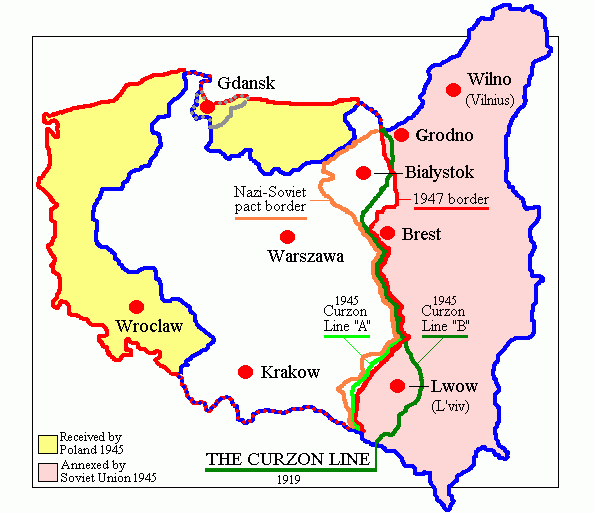
English: Map of Poland in 1945.
Deutsch: Karte Polens (1945). |
| Datums | |
| Avots | Paša darbs (originally at en.wikipedia) |
| Autors | Adam Carr |
| Citas versijas | Derivative works of this file: Polszczyzna kresowa.png |
Licence
| |
This work has been released into the public domain by its author, Adam Carr, at the angļu Vikipēdija project. This applies worldwide. In case this is not legally possible: |
Faila hronoloģija
Uzklikšķini uz datums/laiks kolonnā esošās saites, lai apskatītos, kā šis fails izskatījās tad.
| Datums/Laiks | Attēls | Izmēri | Dalībnieks | Komentārs | |
|---|---|---|---|---|---|
| tagadējais | 2018. gada 18. jūnijs, plkst. 21.29 | | 594 × 513 (13 KB) | Julieta39 | According with 1919 maps |
| 2016. gada 30. jūnijs, plkst. 06.57 |  | 594 × 513 (15 KB) | Poeticbent | r/m dead space, spelling | |
| 2007. gada 12. februāris, plkst. 10.58 |  | 617 × 513 (9 KB) | Unomano | Map of Poland in 1945, drawn by en:User: Adam Carr. From en:Image:Map of Poland (1945).png {{PD-user-w|en|English Wikipedia|Adam Carr}} Category:Maps of the history of Poland | |
| 2005. gada 2. decembris, plkst. 17.43 |  | 617 × 513 (9 KB) | Thuresson | Map of Poland in 1945, drawn by User: Adam Carr. From en:Image:Map of Poland (1945).png {{PD-user-w|en|English Wikipedia|Adam Carr}} Category:Historical maps of Poland |
.png)
Faila lietojums
Šo failu izmanto šajā 1 lapā:
Globālais faila lietojums
Šīs Vikipēdijas izmanto šo failu:
- Izmantojums ang.wikipedia.org
- Izmantojums ar.wikipedia.org
- Izmantojums be-tarask.wikipedia.org
- Izmantojums be.wikipedia.org
- Izmantojums bg.wikipedia.org
- Izmantojums ca.wikipedia.org
- Izmantojums cs.wikipedia.org
- Izmantojums de.wikibooks.org
- Izmantojums el.wikipedia.org
- Izmantojums en.wikipedia.org
- Polish People's Republic
- User:Adam Carr/My archive of original cartographic contributions
- History of German settlement in Central and Eastern Europe
- User:Landau7
- Talk:Flight and expulsion of Germans (1944–1950)/Archive 10
- Polish population transfers (1944–1946)
- User:TheNoiseBringer
- User:Halibutt/expulsion
- User:Falcaorib
- Izmantojums es.wikipedia.org
- Izmantojums fa.wikipedia.org
- Izmantojums fr.wikipedia.org
- Izmantojums id.wikipedia.org
- Izmantojums it.wikipedia.org
- Izmantojums kk.wikipedia.org
- Izmantojums nl.wikipedia.org
- Izmantojums pt.wikipedia.org
- Izmantojums ro.wikipedia.org
Skatīt šī faila pilno globālo izmantojumu.
.png)
.png)