Attēls:Map of eastern Xinjiang 1939 with prehistoric sites and the courses of the Silk Roads.jpg

Lapas saturs netiek atbalstīts citās valodās.
Vikipēdijas lapa

Sākotnējais fails(831 × 777 pikseļi, faila izmērs: 297 KB, MIME tips: image/jpeg)

Apraksts
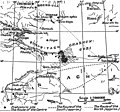
English: Map of eastern Xinjiang with prehistoric sites and the courses of the Silk Roads by Folke Bergman 1939.
Deutsch: Landkarte von Folke Bergman vom östlichen Xinjiang aus dem Jahr 1939 mit prähistorischen Fundstätten und den Routen der Seidenstraße. Bilderklärungen: . Prähistorische Fundstätte, ...... mittlere Route, — — — — vermutete südliche Route, - - - - - vermutete nördliche Route.
Datums created: 1939 after the Sino-Swedish Expedition in China 1927-1933.
Avots Map of eastern Xinjiang with prehistoric sites and the courses of the Silk Roads by Folke Bergman in his Book Archaeological Researches in Sinkiang. Especially the Lop-Nor Region. (Reports: Publication 7), Stockholm 1939, Page 25 Fig. 4. Copyright 2006: Sven Hedin foundation, Stockholm. [1]
Autors Folke Bergman
Atļauja:
(Šī faila izmantošana citur)

Permission cc-by-2.5 from the date 2006.08.23 by the keeper of the Sven Hedin Foundation Håkan Wahlquist, Box 27 140, SE-102 52 Stockholm, Sweden, Phone: +46-8-519 550 18, fax: +46-8-519 550 70, e-mail: hakan.wahlquist@etnografiska.se [2]

Svenska: Du måste ange upphovsmannen och/eller licensgivaren på det sätt de anger: Sven Hedin Foundation, Stockholm.
Deutsch: Namensnennung: Sie müssen den Namen des Autors/Rechtsinhabers Sven Hedin Foundation nennen: Sven Hedin Foundation, Stockholm.
w:en:Creative Commons
atsaucoties
Šis fails tiek izplatīts saskaņā ar licences Creative Commons Atsauce 2.5 Vispārējiem noteikumiem.
Jūs varat brīvi:
  • koplietot – kopēt, izplatīt un pārraidīt darbu
  • remiksēt – pielāgot darbu
Saskaņā ar šādiem nosacījumiem:
  • atsaucoties – Tev ir jānorāda autors, saite uz licenci un to, vai veiktas kādas izmaiņas. To var darīt jebkādā saprātīgā veidā, bet ne tādā, kas norādītu, ka licencētājs atbalsta tevi vai veidu, kā tu izmanto šo darbu.

Captions

Pievieno vienas rindiņas aprakstu, ko šis fails attēlo

Šajā failā attēlotais

attēlo

Faila hronoloģija

Uzklikšķini uz datums/laiks kolonnā esošās saites, lai apskatītos, kā šis fails izskatījās tad.

Datums/LaiksAttēlsIzmēriDalībnieksKomentārs
tagadējais2006. gada 18. septembris, plkst. 17.002006. gada 18. septembris, plkst. 17.00 versijas sīktēls831 × 777 (297 KB)Michael Gäbler{{Information| |Description= Map of eastern Xinjiang with prehistoric sites and the courses of the Silk Roads by Folke Bergman 1939. de: Landkarte von Folke Bergman vom östlichen Xinjiang aus dem Jahr 1939 mit prehistorischen Fundstätten und den Routen

Šo failu izmanto šajā 1 lapā:

Globālais faila lietojums

Šīs Vikipēdijas izmanto šo failu:

Metadati