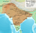
Attēls:Maurya Empire, c.250 BCE 2.png

Lapas saturs netiek atbalstīts citās valodās.
Vikipēdijas lapa

Sākotnējais fails(1 200 × 1 121 pikseļi, faila izmērs: 2,26 MB, MIME tips: image/png)

Kopsavilkums

Apraksts
English: Note: This was the standard "textbook" map of the Maurya Empire. Historians are now arguing that the Maurya Empire did not include large parts of India, which were controlled by autonomous tribes. For such a map, see File:Maurya Empire, c.250 BCE.png.
Alternative map of Maurya Empire

Boundaries are based on Charles Joppen Historical Atlas of India (1907), see File:India_in_250_B._C.jpg.

Other Sources:

Other sources:

  • Grainger, John D. (1990, 2014). Seleukos Nikator: Constructing a Hellenistic Kingdom. Routledge.
  • Keay, John (2000). India, a History. New York: Harper Collins Publishers.
  • Kulke, H.; Rothermund, D. (2004). A History of India, 4th, Routledge.
  • Puri, Baji Nath (1996). Buddhism in Central Asia. Delhi: Motilal Banarsidass.
  • Raychaudhuri, H. C.; Mukherjee, B. N. (1996). Political History of Ancient India: From the Accession of Parikshit to the Extinction of the Gupta Dynasty. Oxford University Press.
  • Stein, Burton (1998). A History of India (1st ed.), Oxford: Wiley-Blackwell.

Notes:

  • Sri Lanka and the southernmost parts of India (modern Tamil Nadu and Kerala) remained independent, despite the diplomacy and cultural influence of their larger neighbor to the north (Schwartzberg 1992, p. 18; Kulke & Rothermund 2004, p. 68).
  • The account of Strabo indicates that the western-most territory of the empire extended from the southeastern Hindu Kush, through the region of Kandahar, to coastal Baluchistan south of that (Raychaudhuri & Mukherjee 1996, p. 594).
  • The claim that Aria/Herat was one of the provinces (alongside Arachosia, Gedrosia, and Paropamisadae) ceded by Seleucus to Chandragupta Maurya is often repeated, but Aria (modern Herat) "has been wrongly included in the list of ceded satrapies by some scholars [...] on the basis of wrong assessments of the passage of Strabo [...] and a statement by Pliny." (Raychaudhuri & Mukherjee 1996, p. 594). Seleucus "must [...] have held Aria", and furthermore, his "son Antiochos was active there fifteen years later." (Grainger 2014, p. 109).
  • "The region of Aria is definitely known to have been Seleucid under Seleucus I and Antiochus I as it definitely was after Antiochus III's great campaign in the east against the Parthians and Bactrians. [...] There is no evidence whatever that it did not remain Seleucid, like Drangiana, with which it is linked by easy routes." -Susan M. Sherwin-White and Amélie Kuhrt (1993) From Samarkhand to Sardis: A New Approach to the Seleucid Empire, University of California Press, pp.79-80.
  • It is recorded that Drangiana province continued to be in the Seleucids' hands, as per [1].
  • "Desert of Gedrosia [...] was left an unclaimed wilderness." —Kosmin, Paul J. (2014), The Land of the Elephant Kings Space, Territory, and Ideology in the Seleucid Empire, Harvard University Press, p.16
  • Schwartzberg (p. 18) speculates about the Buddhist culture and Kharosthi inscriptions/manuscripts found in Khotan, but these texts from Khotan, Turfan, and Tajikstan have all been shown to be later than the 1st century BCE (Puri, p. 185).
Datums
Avots Paša darbs
Autors Avantiputra7

Licence

Es, šī darba autortiesību īpašnieks, publicēju to saskaņā ar šo licenci:
w:en:Creative Commons
atsaucoties nemainot licenci
Šis fails tiek izplatīts saskaņā ar licences Creative Commons Atsauce-Līdzīgi Noteikumi 3.0 Vispārējiem noteikumiem.
Jūs varat brīvi:
  • koplietot – kopēt, izplatīt un pārraidīt darbu
  • remiksēt – pielāgot darbu
Saskaņā ar šādiem nosacījumiem:
  • atsaucoties – Tev ir jānorāda autors, saite uz licenci un to, vai veiktas kādas izmaiņas. To var darīt jebkādā saprātīgā veidā, bet ne tādā, kas norādītu, ka licencētājs atbalsta tevi vai veidu, kā tu izmanto šo darbu.
  • nemainot licenci – Ja tu miksē, pārveido vai izmanto materiālu, tev savs devums jāpublicē ar to pašu vai saderīgu licenci kā oriģināls.

Captions

Pievieno vienas rindiņas aprakstu, ko šis fails attēlo

Šajā failā attēlotais

attēlo

3 jūlijs 2014

image/png

Faila hronoloģija

Uzklikšķini uz datums/laiks kolonnā esošās saites, lai apskatītos, kā šis fails izskatījās tad.

(Jaunākās | Senākās) Skatīt (10 jaunākas | ) (10 | 20 | 50 | 100 | 250 | 500 vienā lapā).
Datums/LaiksAttēlsIzmēriDalībnieksKomentārs
tagadējais2024. gada 30. aprīlis, plkst. 14.012024. gada 30. aprīlis, plkst. 14.01 versijas sīktēls1 200 × 1 121 (2,26 MB)Avantiputra7western borders: see talk page
2024. gada 16. aprīlis, plkst. 07.372024. gada 16. aprīlis, plkst. 07.37 versijas sīktēls1 200 × 1 121 (2,26 MB)Avantiputra7Reverted to version as of 11:12, 5 April 2024 (UTC) - vandalism
2024. gada 14. aprīlis, plkst. 10.372024. gada 14. aprīlis, plkst. 10.37 versijas sīktēls1 200 × 1 121 (2,18 MB)Layman7676Reverted to version as of 11:12, 4 April 2024 (UTC) The map you are publishing isn't based on wha vincient Arthur really said.
2024. gada 5. aprīlis, plkst. 14.122024. gada 5. aprīlis, plkst. 14.12 versijas sīktēls1 200 × 1 121 (2,26 MB)Avantiputra7Reverted to version as of 08:27, 3 April 2024 (UTC) - vandalism
2024. gada 4. aprīlis, plkst. 14.122024. gada 4. aprīlis, plkst. 14.12 versijas sīktēls1 200 × 1 121 (2,18 MB)Chakravartin1929Reverted to version as of 05:41, 26 March 2024 (UTC) This is the true map. It depicts The mauryan map accurately.
2024. gada 3. aprīlis, plkst. 11.272024. gada 3. aprīlis, plkst. 11.27 versijas sīktēls1 200 × 1 121 (2,26 MB)Avantiputra7Reverted to version as of 11:06, 3 March 2024 (UTC)
2024. gada 26. marts, plkst. 08.412024. gada 26. marts, plkst. 08.41 versijas sīktēls1 200 × 1 121 (2,18 MB)Chakravartin1929Reverted to version as of 09:06, 3 March 2024 (UTC)
2024. gada 3. marts, plkst. 14.062024. gada 3. marts, plkst. 14.06 versijas sīktēls1 200 × 1 121 (2,26 MB)Avantiputra7Reverted to version as of 11:10, 29 January 2024 (UTC)
2024. gada 3. marts, plkst. 12.062024. gada 3. marts, plkst. 12.06 versijas sīktēls1 200 × 1 121 (2,18 MB)Chakravartin1929Reverted to version as of 16:50, 14 December 2023 (UTC) This map is better.
2024. gada 29. janvāris, plkst. 14.102024. gada 29. janvāris, plkst. 14.10 versijas sīktēls1 200 × 1 121 (2,26 MB)Avantiputra7tweaked
(Jaunākās | Senākās) Skatīt (10 jaunākas | ) (10 | 20 | 50 | 100 | 250 | 500 vienā lapā).

Šo failu izmanto šajā 1 lapā:

Globālais faila lietojums

Šīs Vikipēdijas izmanto šo failu:

Skatīt šī faila pilno globālo izmantojumu.

Metadati