
Attēls:Population density of Ireland map2002.svg

Size of this PNG preview of this SVG file: 480 × 600 pikseļi. Citi izmēri: 192 × 240 pikseļi | 384 × 480 pikseļi | 614 × 768 pikseļi | 819 × 1 024 pikseļi | 1 638 × 2 048 pikseļi.
Sākotnējais fails (SVG fails, definētais izmērs 800 × 1 000 pikseļi, faila izmērs: 621 KB)
| Šis fails ir no Vikikrātuves. Tā apraksts no attēla lapas Vikikrātuvē ir parādīts zemāk. Vikikrātuve ir brīvi licencēta failu krātuve. Tu vari tai palīdzēt. |
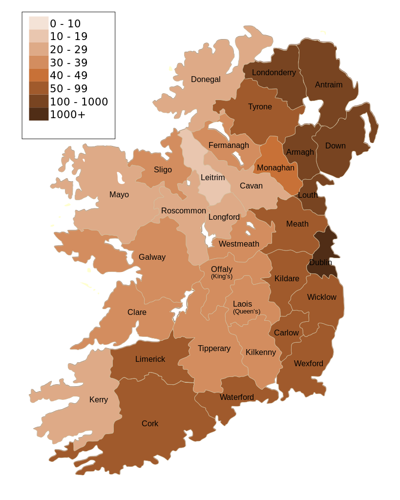
| Apraksts | Map of Ireland's population density (people per km2). Based upon Republic of Ireland - 2002 Census results. |
| Datums | (UTC) |
| Avots | |
| Autors |
|
| Citas versijas | Derivative works of this file: Population density of Ireland map2002 RU.svg |
| This is a retouched picture, which means that it has been digitally altered from its original version. Modifications: Map of Ireland's population density (people per km2). Based upon Republic of Ireland - 2002 Census results.. The original can be viewed here: Ireland complete.svg:
|
Es, šī darba autortiesību īpašnieks, publicēju to saskaņā ar šo licenci:
| I, the copyright holder of this work, release this work into the public domain. This applies worldwide. In some countries this may not be legally possible; if so: I grant anyone the right to use this work for any purpose, without any conditions, unless such conditions are required by law. |
Original upload log
This image is a derivative work of the following images:
- File:Ireland_complete.svg licensed with PD-self
- 2007-06-23T17:06:44Z Future Perfect at Sunrise 800x1000 (594536 Bytes) {{Information |Description= |Source=self-made |Date= |Author= [[User:Future Perfect at Sunrise|Future Perfect at Sunrise]] }}
- 2007-06-23T16:45:52Z Future Perfect at Sunrise 800x1000 (590003 Bytes) {{Information |Description= |Source=self-made |Date= |Author= [[User:Future Perfect at Sunrise|Future Perfect at Sunrise]] }}
- 2007-06-23T16:35:48Z Future Perfect at Sunrise 2000x2500 (606764 Bytes) {{Information |Description=SVG map of Ireland. |Source=self-made |Date=23 June 2007 |Author= [[User:Future Perfect at Sunrise|Future Perfect at Sunrise]] }} Note: the SVG code contains separate levels showing boundaries and
Uploaded with derivativeFX
Faila hronoloģija
Uzklikšķini uz datums/laiks kolonnā esošās saites, lai apskatītos, kā šis fails izskatījās tad.
| Datums/Laiks | Attēls | Izmēri | Dalībnieks | Komentārs | |
|---|---|---|---|---|---|
| tagadējais | 2009. gada 17. oktobris, plkst. 17.30 | | 800 × 1 000 (621 KB) | The Illusional Ministry | Dublin now in black text |
| 2009. gada 17. oktobris, plkst. 17.27 |  | 800 × 1 000 (621 KB) | The Illusional Ministry | {{Information |Description=Map of Ireland's population density (people per km2). Based upon Republic of Ireland - 2002 Census results. |Source=*File:Ireland_complete.svg |Date=2009-10-17 14:25 (UTC) |Author=*File:Ireland_complete.svg: '''Futur |
Faila lietojums
Šo failu neizmanto nevienā lapā.
Globālais faila lietojums
Šīs Vikipēdijas izmanto šo failu:
- Izmantojums de.wikipedia.org
- Izmantojums gv.wikipedia.org
- Izmantojums he.wikipedia.org
- Izmantojums hu.wikipedia.org
- Izmantojums kn.wikipedia.org
- Izmantojums sd.wikipedia.org
- Izmantojums te.wikipedia.org