
Attēls:Wales Carmarthenshire locator map.svg

Size of this PNG preview of this SVG file: 502 × 600 pikseļi. Citi izmēri: 201 × 240 pikseļi | 402 × 480 pikseļi | 643 × 768 pikseļi | 857 × 1 024 pikseļi | 1 714 × 2 048 pikseļi | 1 047 × 1 251 pikseļi.
Sākotnējais fails (SVG fails, definētais izmērs 1 047 × 1 251 pikseļi, faila izmērs: 151 KB)
| Šis fails ir no Vikikrātuves. Tā apraksts no attēla lapas Vikikrātuvē ir parādīts zemāk. Vikikrātuve ir brīvi licencēta failu krātuve. Tu vari tai palīdzēt. |
Kopsavilkums
| Apraksts |
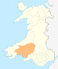
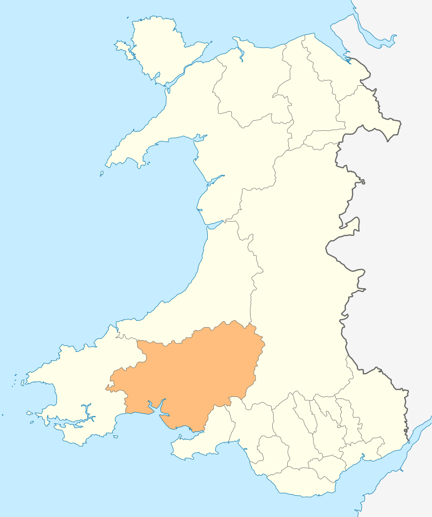
Deutsch: Lagekarte von Carmarthenshire in Wales
English: Locator map of Carmarthenshire in Wales |
| Datums | |
| Avots | Paša darbs |
| Autors | NordNordWest |
| Atļauja: (Šī faila izmantošana citur) |
Es, šī darba autortiesību īpašnieks, publicēju to saskaņā ar šo licenci: Šis fails tiek izplatīts saskaņā ar licences Creative Commons Atsauce-Līdzīgi Noteikumi 3.0 Vispārējiem noteikumiem.
|

|
Šī karte bija uzlabota vācu Kartenwerkstatt. Jūs arī varat piedāvāt citas kartes uzlabošanai.
|
Faila hronoloģija
Uzklikšķini uz datums/laiks kolonnā esošās saites, lai apskatītos, kā šis fails izskatījās tad.
| Datums/Laiks | Attēls | Izmēri | Dalībnieks | Komentārs | |
|---|---|---|---|---|---|
| tagadējais | 2010. gada 4. maijs, plkst. 21.49 | | 1 047 × 1 251 (151 KB) | NordNordWest | {{int:filedesc}} {{Information |Description= {{de|Lagekarte von Carmarthenshire in Wales}} {{en|Locator map of Carmarthenshire in Wales}} |Source={{Own}} |Date=2010-05-04 |Author={{U|NordNordWest}} |Permission={{self|cc-by-sa-3.0}} |other_versions= }} {{ |
Faila lietojums
Šo failu izmanto šajā 1 lapā:
Globālais faila lietojums
Šīs Vikipēdijas izmanto šo failu:
- Izmantojums cs.wikipedia.org
- Izmantojums de.wikipedia.org
- Izmantojums en.wikipedia.org
- WWT Llanelli Wetlands Centre
- Carmarthenshire
- Sandy, Carmarthenshire
- Llanelli
- Carmarthen
- Llandeilo
- Newcastle Emlyn
- Whitland
- Burry Port
- Kidwelly
- Llandovery
- Laugharne
- St Clears
- Pendine
- Garreg Lwyd (Black Mountain)
- Llandybie
- Llanwrda
- Afon Cothi
- Cwmann
- Bancyfelin
- Talley
- Aber-arad
- Aber-giar
- Abergorlech
- Abernant, Carmarthenshire
- Cross Hands
- Pantyffynnon
- List of places in Carmarthenshire
- Brandy Hill, Wales
- Caio, Carmarthenshire
- Template:Carmarthenshire-geo-stub
- Bryn, Llanelli
- Pemberton, Carmarthenshire
- Dafen, Carmarthenshire
- Pendine Museum of Speed
- Usk Reservoir
- River Cywyn
- Five Roads
- Maesybont
- Glanymor
- Trefawr Track
- Bethlehem, Carmarthenshire
- Stradey
- Cross Inn
- Bronwydd
- Llanfihangel Rhos-y-Corn
- St Ishmael, Carmarthenshire
- Elvet Hundred
Skatīt šī faila pilno globālo izmantojumu.