
Attēls:1820 Виленская Губерния.jpg

Sākotnējais fails (4 908 × 4 739 pikseļi, faila izmērs: 20,13 MB, MIME tips: image/jpeg)
| Šis fails ir no Vikikrātuves. Tā apraksts no attēla lapas Vikikrātuvē ir parādīts zemāk. Vikikrātuve ir brīvi licencēta failu krātuve. Tu vari tai palīdzēt. |
Kopsavilkums
| Apraksts |
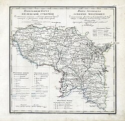
English: Geographic atlas of the Russian Empire, Kingdom of Poland and Grand Duchy of Finland is located in governorates in the Russian and French. 1821.
Русский: Географический атлас Российской империи, Царства Польского и Великого княжества Финляндского расположенный по губерниям на русском и французском языках. 1821 год. Виленская Губерния. Генеральная карта.
Français : Atlas Geografique de L Empire de Russie, du Royaume de Pologne et du Grand Duche de Finlande divise en Gouvernemens. Mappa Generalna Gubernii Wilenskiey. 1821. |
| Datums | |
| Avots | http://rutracker.org/forum/viewtopic.php?t=600838 |
| Autors | Пядышев, Военно-Картографическое Депо |
Licence
|
This work is in the public domain in its country of origin and other countries and areas where the copyright term is the author's life plus 70 years or fewer.
| |
| This file has been identified as being free of known restrictions under copyright law, including all related and neighboring rights. | |
Faila hronoloģija
Uzklikšķini uz datums/laiks kolonnā esošās saites, lai apskatītos, kā šis fails izskatījās tad.
| Datums/Laiks | Attēls | Izmēri | Dalībnieks | Komentārs | |
|---|---|---|---|---|---|
| tagadējais | 2009. gada 28. marts, plkst. 12.53 | | 4 908 × 4 739 (20,13 MB) | Berillium | {{Information |Description={{en|1=Geographic atlas of the Russian Empire, Kingdom of Poland and Grand Duchy of Finland is located in governorates in the Russian and French. 1821.}} {{ru|1=Географический атлас Российской имп |
Faila lietojums
Šo failu izmanto šajās 2 lapās:
Globālais faila lietojums
Šīs Vikipēdijas izmanto šo failu:
- Izmantojums be.wikipedia.org
- Izmantojums et.wikipedia.org
- Izmantojums fi.wikipedia.org
- Izmantojums he.wikipedia.org
- Izmantojums lt.wikipedia.org
- Izmantojums lt.wikibooks.org
- Izmantojums pl.wikipedia.org
- Izmantojums ru.wikipedia.org