
Attēls:15th Arrondissement of Paris as seen from Pont de Bir-Hakeim 140507 1.jpg

Sākotnējais fails (7 578 × 3 991 pikseļi, faila izmērs: 13,67 MB, MIME tips: image/jpeg)
| Šis fails ir no Vikikrātuves. Tā apraksts no attēla lapas Vikikrātuvē ir parādīts zemāk. Vikikrātuve ir brīvi licencēta failu krātuve. Tu vari tai palīdzēt. |
Kopsavilkums
| Apraksts |
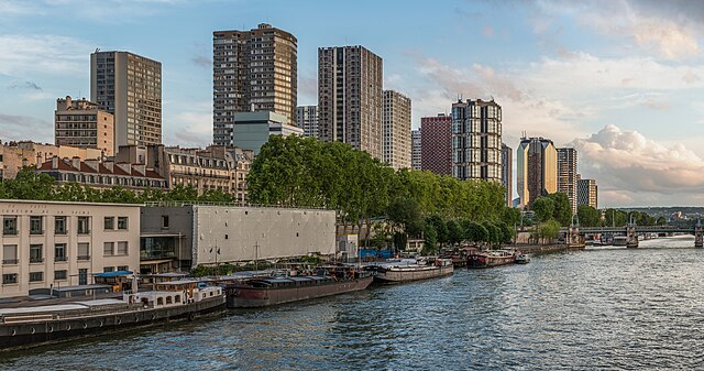
English: The 15th arrondissement of Paris as seen from the Pont de Bir-Hakeim, shortly before sunset.
Español: XV Distrito de París, Francia, visto desde el puente de Bir-Hakeim poco antes del atardecer.
|
||||
| Datums | |||||
| Avots | Paša darbs | ||||
| Autors | DXR |


| Camera location | | View this and other nearby images on: OpenStreetMap |
|---|
Assessment
|
This image was selected as picture of the day on Wikimedia Commons for 7 May 2024. It was captioned as follows: English: The 15th arrondissement of Paris as seen from the Pont de Bir-Hakeim, shortly before sunset Other languages:
Deutsch: Das 15. Pariser Arrondissement gesehen von der Pont de Bir-Hakeim kurz vor Sonnenuntergang. English: The 15th arrondissement of Paris as seen from the Pont de Bir-Hakeim, shortly before sunset Español: XV Distrito de París, Francia, visto desde el puente de Bir-Hakeim poco antes del atardecer. Magyar: Párizs 15. kerülete a Pont de Bir-Hakeimről nézve, röviddel naplemente előtt Nederlands: Het 15e arrondissement van de Franse hoofdstad Parijs, gezien vanaf de Pont de Bir-Hakeim Português: 15.º arrondissement de Paris, França, visto da Ponte de Bir-Hakeim pouco antes do pôr do sol. |
|
|
Panorama by DXR (Category)
The photograph above is a panoramic image which was created by me, Daniel Vorndran, and uploaded here as User:DXR.
Please note:
|


Licence
- Jūs varat brīvi:
- koplietot – kopēt, izplatīt un pārraidīt darbu
- remiksēt – pielāgot darbu
- Saskaņā ar šādiem nosacījumiem:
- atsaucoties – Tev ir jānorāda autors, saite uz licenci un to, vai veiktas kādas izmaiņas. To var darīt jebkādā saprātīgā veidā, bet ne tādā, kas norādītu, ka licencētājs atbalsta tevi vai veidu, kā tu izmanto šo darbu.
- nemainot licenci – Ja tu miksē, pārveido vai izmanto materiālu, tev savs devums jāpublicē ar to pašu vai saderīgu licenci kā oriģināls.
Faila hronoloģija
Uzklikšķini uz datums/laiks kolonnā esošās saites, lai apskatītos, kā šis fails izskatījās tad.
| Datums/Laiks | Attēls | Izmēri | Dalībnieks | Komentārs | |
|---|---|---|---|---|---|
| tagadējais | 2014. gada 4. jūnijs, plkst. 00.51 | | 7 578 × 3 991 (13,67 MB) | DXR | Selective cloud brightening top right corner |
| 2014. gada 2. jūnijs, plkst. 16.31 |  | 7 578 × 3 991 (13,67 MB) | DXR | Slight straightening | |
| 2014. gada 8. maijs, plkst. 16.09 |  | 7 595 × 4 000 (14,38 MB) | DXR | Spots removed | |
| 2014. gada 8. maijs, plkst. 15.59 |  | 7 595 × 4 000 (14,3 MB) | DXR | VicuñaUploader 1.20 |
Faila lietojums
Šo failu neizmanto nevienā lapā.
Globālais faila lietojums
Šīs Vikipēdijas izmanto šo failu:
- Izmantojums ast.wikipedia.org
- Izmantojums av.wikipedia.org
- Izmantojums az.wikipedia.org
- Izmantojums crh.wikipedia.org
- Izmantojums cv.wikipedia.org
- Izmantojums de.wikivoyage.org
- Izmantojums el.wikipedia.org
- Izmantojums en.wikivoyage.org
- Izmantojums es.wikipedia.org
- Izmantojums fr.wikipedia.org
- Izmantojums fr.wikivoyage.org
- Izmantojums hu.wikipedia.org
- Izmantojums hy.wikipedia.org
- Izmantojums id.wikipedia.org
- Izmantojums it.wiktionary.org
- Izmantojums ka.wikipedia.org
- Izmantojums kk.wikipedia.org
- Izmantojums ko.wikipedia.org
- Izmantojums lez.wikipedia.org
- Izmantojums mdf.wikipedia.org
- Izmantojums mk.wikipedia.org
- Izmantojums myv.wikipedia.org
- Izmantojums os.wikipedia.org
- Izmantojums pt.wikipedia.org
- Izmantojums ro.wikipedia.org
- Izmantojums ru.wikipedia.org
- Izmantojums sah.wikipedia.org
- Izmantojums tt.wikipedia.org
- Izmantojums tyv.wikipedia.org
- Izmantojums udm.wikipedia.org
- Izmantojums uk.wikipedia.org
- Izmantojums vep.wikipedia.org
- Izmantojums vi.wikipedia.org
Skatīt šī faila pilno globālo izmantojumu.