
Attēls:1973 sinai war maps2.jpg
Sākotnējais fails (1 165 × 894 pikseļi, faila izmērs: 213 KB, MIME tips: image/jpeg)
| Šis fails ir no Vikikrātuves. Tā apraksts no attēla lapas Vikikrātuvē ir parādīts zemāk. Vikikrātuve ir brīvi licencēta failu krātuve. Tu vari tai palīdzēt. |

|
This historical map image could be re-created using vector graphics as an SVG file. This has several advantages; see Commons:Media for cleanup for more information. If an SVG form of this image is available, please upload it and afterwards replace this template with
{{vector version available|new image name}}.
It is recommended to name the SVG file “1973 sinai war maps2.svg”—then the template Vector version available (or Vva) does not need the new image name parameter. |


Kopsavilkums
| Apraksts |
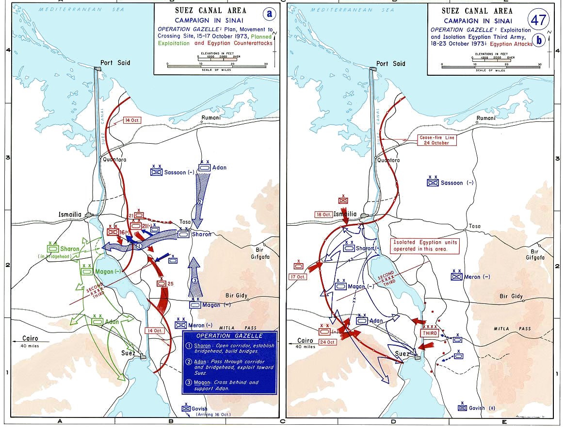
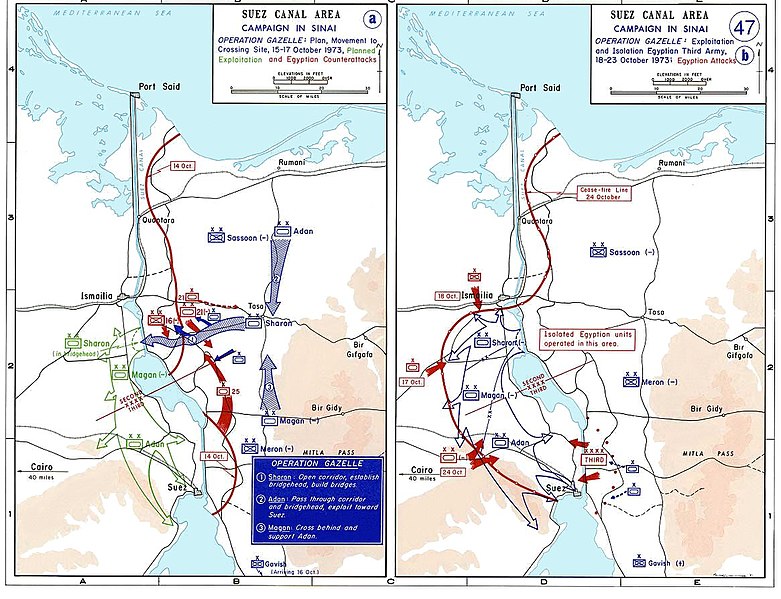
العربية: خريطة للتحركات العسكرية على الجبهة المصرية في حرب أكتوبر في الفترة بين 15 و 23 أكتوبر.
English: Sinai maps, from the US Military Academy History archives (copyright US government?)
In 1938 the predecessors of what is today The Department of History at the United States Military Academy began developing a series of campaign atlases to aid in teaching cadets a course entitled, "History of the Military Art." Since then, the Department has produced over six atlases and more than one thousand maps, encompassing not only America’s wars but global conflicts as well. In keeping abreast with today's technology, the Department of History is providing these maps on the internet as part of the department's outreach program. The maps were created by the United States Military Academy’s Department of History and are the digital versions from the atlases printed by the United States Defense Printing Agency. We gratefully acknowledge the accomplishments of the department's former cartographer, Mr. Edward J. Krasnoborski, along with the works of our present cartographer, Mr. Frank Martini. Please be aware that these maps are large in file size and may require substantial download times.. |
| Datums | |
| Avots |
|
| Autors | Wikiliki |
| Citas versijas |
 |
Licence
This work is in the public domain in the United States because it is a work prepared by an officer or employee of the United States Government as part of that person’s official duties under the terms of Title 17, Chapter 1, Section 105 of the US Code.
Note: This only applies to original works of the Federal Government and not to the work of any individual U.S. state, territory, commonwealth, county, municipality, or any other subdivision. This template also does not apply to postage stamp designs published by the United States Postal Service since 1978. (See § 313.6(C)(1) of Compendium of U.S. Copyright Office Practices). It also does not apply to certain US coins; see The US Mint Terms of Use.
|
 | |
| This file has been identified as being free of known restrictions under copyright law, including all related and neighboring rights. | ||
This file is a work of a U.S. Army soldier or employee, taken or made as part of that person's official duties. As a work of the U.S. federal government, it is in the public domain in the United States.
|
 |
Faila hronoloģija
Uzklikšķini uz datums/laiks kolonnā esošās saites, lai apskatītos, kā šis fails izskatījās tad.
| Datums/Laiks | Attēls | Izmēri | Dalībnieks | Komentārs | |
|---|---|---|---|---|---|
| tagadējais | 2009. gada 2. jūnijs, plkst. 00.24 | | 1 165 × 894 (213 KB) | Hohum | Cleaned up. |
| 2005. gada 7. oktobris, plkst. 02.54 |  | 1 165 × 894 (170 KB) | Wikiliki | Sinai maps, from the US Military Academy History archives (copyright US government?) *Source: Department of History, U.S. Military Academy *URL: [http://www.dean.usma.edu/history/web03/atlases/map%20home.htm] *Background information: ''In 1938 the prede |
Faila lietojums
Šo failu izmanto šajā 1 lapā:
Globālais faila lietojums
Šīs Vikipēdijas izmanto šo failu:
- Izmantojums ast.wikipedia.org
- Izmantojums ca.wikipedia.org
- Izmantojums cs.wikipedia.org
- Izmantojums da.wikipedia.org
- Izmantojums de.wikipedia.org
- Izmantojums el.wikipedia.org
- Izmantojums en.wikipedia.org
- Izmantojums es.wikipedia.org
- Izmantojums eu.wikipedia.org
- Izmantojums he.wikipedia.org
- Izmantojums it.wikipedia.org
- Izmantojums it.wikibooks.org
- Izmantojums ms.wikipedia.org
- Izmantojums nl.wikipedia.org
- Izmantojums nn.wikipedia.org
- Izmantojums pl.wikipedia.org
- Izmantojums pnb.wikipedia.org
- Izmantojums ro.wikipedia.org
- Izmantojums ru.wikipedia.org
- Izmantojums sh.wikipedia.org
- Izmantojums sl.wikipedia.org
- Izmantojums sq.wikipedia.org
- Izmantojums sr.wikipedia.org
- Izmantojums te.wikipedia.org
- Izmantojums uk.wikipedia.org
- Izmantojums ur.wikipedia.org
- Izmantojums vi.wikipedia.org
- Izmantojums www.wikidata.org
- Izmantojums zh.wikipedia.org