
Attēls:Afghanistan map.png
Augstāka izšķirtspēja nav pieejama.
Afghanistan_map.png (326 × 350 pikseļi, faila izmērs: 11 KB, MIME tips: image/png)
| Šis fails ir no Vikikrātuves. Tā apraksts no attēla lapas Vikikrātuvē ir parādīts zemāk. Vikikrātuve ir brīvi licencēta failu krātuve. Tu vari tai palīdzēt. |

|
This file has been superseded by CIA map of Afghanistan in 2007.gif. It is recommended to use the other file. Please note that deleting superseded images requires consent. Reason to use the other file: "Superseded. Do NOT delete!"
|

|
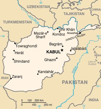
Map of Afghanistan.
[]
UNOCHA Versions
-
 English
 -
 বাংলা
বাংলা -
 español
_-_AFG_-_UNOCHA.svg)
_-_AFG_-_UNOCHA-bn.svg)
_-_AFG_-_UNOCHA-es.svg)
CIA WFB Versions
-
 Original File
 -
 English
 -
 हिन्दी
 -
 中文(臺灣)
 -
 中文
中文 -
 français
 -
 العربية
 -
 čeština


Other English Versions


This image is in the public domain because it contains materials that originally came from the United States Central Intelligence Agency's World Factbook.
|
 |
Faila hronoloģija
Uzklikšķini uz datums/laiks kolonnā esošās saites, lai apskatītos, kā šis fails izskatījās tad.
| Datums/Laiks | Attēls | Izmēri | Dalībnieks | Komentārs | |
|---|---|---|---|---|---|
| tagadējais | 2011. gada 5. marts, plkst. 19.29 | | 326 × 350 (11 KB) | Ras67 | cropped and squeezed |
| 2005. gada 17. aprīlis, plkst. 20.39 |  | 331 × 355 (21 KB) | Shauni | Map of Afghanistan. This image is a map or flag taken and/or modified from the Central Intelligence Agency's World Factbook. Under United States copyright law, all information and images from the World Factbook are public domain. |
Faila lietojums
Šo failu neizmanto nevienā lapā.
Globālais faila lietojums
Šīs Vikipēdijas izmanto šo failu:
- Izmantojums ban.wikipedia.org
- Izmantojums da.wikipedia.org
- Izmantojums en.wikipedia.org
- Izmantojums en.wikibooks.org
- Izmantojums en.wikinews.org
- Izmantojums es.wikinews.org
- Izmantojums fa.wikipedia.org
- کاربر:Artacoana
- کاربر:Sanchooli
- کاربر:Sepehrnoush/nv/mtag
- کاربر:وب پدر
- کاربر:نوید آرین
- کاربر:Ancient relics
- کاربر:علیرضا چوبداری
- کاربر:جعبه کاربر/افغانستان
- کاربر:Erfan Osroes
- کاربر:ERFANINGENIA~fawiki
- کاربر:محک
- کاربر:Sahehco
- کاربر:Torgani
- کاربر:محک/علایقم
- کاربر:Alireza12113
- کاربر:Ebi Mones
- کاربر:Soranikurd
- کاربر:Sam Chalipa
- کاربر:Parspersian1
- کاربر:ر.علامه
- کاربر:Shukayebita
- کاربر:Danial f4
- کاربر:Rashid afghan
- کاربر:راشد عبیدی
- بحث کاربر:Shxahxh
- کاربر:جلیل احمد میرزائی
- کاربر:Amirhosseingholami425
- کاربر:Iri1388
- کاربر:NasrullahSalehS
- کاربر:Sameer.afg
- کاربر:بازی ۳
- Izmantojums fr.wikipedia.org
- Izmantojums it.wikinews.org
- Izmantojums ka.wikipedia.org
- Izmantojums lld.wikipedia.org
- Izmantojums mi.wikipedia.org
- Izmantojums sd.wikinews.org