Attēls:Alemanni expansion.png

Lapas saturs netiek atbalstīts citās valodās.
Vikipēdijas lapa

Alemanni_expansion.png(566 × 499 pikseļi, faila izmērs: 449 KB, MIME tips: image/png)

Kopsavilkums

Apraksts

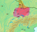
Siedlungsgebiet und Schlachten der Alemannen, 3.-6. Jh. Gepunktet ist der Germanische Limes wie er bis 260 bestand. Die Alemannen werden erstmals im 3. Jh. als am Main siedelnd erwähnt (von Cassius Dio im Zusammenhang mit einem Feldzug von 213). Bis um 280 breitete sich das Siedlungsgebiet nach Süden aus. Ab dem 4. Jh. wurden die Alemannen durch die Franken nach Süden gedrängt, so dass ehemaliges Siedlungsgebiet im Norden nun nicht mehr von Alemannen bewohnt war. Im 3. und 4. Jh. waren Alemannische Kriegerscharen in Gallien unterwegs und wurden wiederholt von der römischen Armee zurückgeschlagen, aber permanent von Alemannen besiedeltes Gebiet befand sich noch ausschliesslich rechtsrheinisch. 406 überschritten die Alemannen den Rhein und besiedelten das Elsass und später auch das Schweizer Mittelland und die Region rund um den Bodensee. Bis im 8. Jh. war das Gebiet der heutigen Deutschschweiz weitgehend Alemannisch (abgesehen von den alpinen (Höchstalemannischen) Gebieten, die im Hochmittelalter noch durch die Walserwanderung erreicht wurden). Kleine Jahreszahlen:

  • 268 Schlacht am Lacus Benacus
  • 271 Alamannen fallen in Oberitalien ein und Schlacht bei Fano
  • 298 (west) Schlacht bei Langres
  • 298 (ost) Schlacht von Vindonissa
  • 356 Juthungen fallen in die Provinz Raetia ein
  • 357 Schlacht von Argentoratum
  • 378 Schlacht bei Argentovaria ---- Regiones de asentamiento de los Alamanes y lugares fechados de sus enfrentamientos contra los romanos. Línea negra = limes.
Avots http://www.rhetorik-netz.de/rhetorik/alemann.htm archive copy at the Wayback Machine, wo wiederum Kartenmaterial aus dem Klett Sprachbuch A/B 10 (1975, ISBN 3123260003) gezeigt wird.
Atļauja:
(Šī faila izmantošana citur)
Es, šī darba autortiesību īpašnieks, publicēju to saskaņā ar šo licenci:
GNU head Ir dota atļauja kopēt, izplatīt un/vai pārveidot šo dokumentu saskaņā ar GNU brīvās dokumentācijas licences, versijas 1.2 vai jebkuras vēlākas versijas, ko publiskojis Brīvās programmatūras fonds nosacījumiem; bez nemainīgajām sadaļā, priekšējā un aizmugurēja'vāka tekstiem. Licences kopija ir iekļauta sadaļā ar nosaukumu GNU brīvās dokumentācijas licence.
w:en:Creative Commons
atsaucoties nemainot licenci
Šis fails tiek izplatīts saskaņā ar licences Creative Commons Atsauce-Līdzīgi Noteikumi 3.0 Vispārējiem noteikumiem.
Jūs varat brīvi:
  • koplietot – kopēt, izplatīt un pārraidīt darbu
  • remiksēt – pielāgot darbu
Saskaņā ar šādiem nosacījumiem:
  • atsaucoties – Tev ir jānorāda autors, saite uz licenci un to, vai veiktas kādas izmaiņas. To var darīt jebkādā saprātīgā veidā, bet ne tādā, kas norādītu, ka licencētājs atbalsta tevi vai veidu, kā tu izmanto šo darbu.
  • nemainot licenci – Ja tu miksē, pārveido vai izmanto materiālu, tev savs devums jāpublicē ar to pašu vai saderīgu licenci kā oriģināls.
This licensing tag was added to this file as part of the GFDL licensing update.
Public domain
This image is in the public domain because it came from the site https://www.demis.nl/products/web-map-server/examples/ and was released by the copyright holder. Permission is granted to copy, distribute and/or modify this map since it is based on free of copyright images from: www.demis.nl. See also approval email on de.wp and its clarification.

Deutsch | English | македонски | മലയാളം | Nederlands | slovenščina | +/−

Public domain This work has been released into the public domain by its copyright holder, www.demis.nl. This applies worldwide.
In some countries this may not be legally possible; if so:
www.demis.nl grants anyone the right to use this work for any purpose, without any conditions, unless such conditions are required by law.

 Geotemporal data
Bounding box
N: 50.3347813°N
W: 3.6714225°E E: 13.0454169°E
S: 44.6987939°N
Georeferencing View the georeferenced map in the Wikimaps Warper

Captions

Pievieno vienas rindiņas aprakstu, ko šis fails attēlo
Area of settlement and battles of Alemanni against Romans, 3rd to 6th cent. A.D. (dotted line: limes until 260)

Šajā failā attēlotais

attēlo

image/png

checksum angļu

9906d577e0095aac0c14ef275d869cd93200950a

data size angļu

460 166 Baits

499 pikselis

566 pikselis

Faila hronoloģija

Uzklikšķini uz datums/laiks kolonnā esošās saites, lai apskatītos, kā šis fails izskatījās tad.

Datums/LaiksAttēlsIzmēriDalībnieksKomentārs
tagadējais2023. gada 19. aprīlis, plkst. 14.472023. gada 19. aprīlis, plkst. 14.47 versijas sīktēls566 × 499 (449 KB)Artoria2e5river names -- might make it easier to read
2008. gada 29. marts, plkst. 15.302008. gada 29. marts, plkst. 15.30 versijas sīktēls566 × 499 (404 KB)Alexander.stohrupdate of prior works, prior authors claimed rights might apply. adjusted location of Moguntiacum. Its just raw pixel works, no source or even map layers were available to do this. The mountains in the previousely covered areas are just sprayed - so dont
2006. gada 24. maijs, plkst. 22.292006. gada 24. maijs, plkst. 22.29 versijas sīktēls566 × 499 (399 KB)Dbachmannupdate
2006. gada 23. maijs, plkst. 23.552006. gada 23. maijs, plkst. 23.55 versijas sīktēls450 × 437 (286 KB)Dbachmann{{GFDL-self}} historical distribution of the Alemanni. work in progress {{GFDL-self}} based on [http://www.rhetorik-netz.de/rhetorik/alemann.htm]

Šo failu izmanto šajā 1 lapā:

Globālais faila lietojums

Šīs Vikipēdijas izmanto šo failu:

Skatīt šī faila pilno globālo izmantojumu.

Metadati