
Attēls:Antarctic Ocean location map.svg

Size of this PNG preview of this SVG file: 600 × 600 pikseļi. Citi izmēri: 240 × 240 pikseļi | 480 × 480 pikseļi | 768 × 768 pikseļi | 1 024 × 1 024 pikseļi | 2 048 × 2 048 pikseļi | 709 × 709 pikseļi.
Sākotnējais fails (SVG fails, definētais izmērs 709 × 709 pikseļi, faila izmērs: 243 KB)
| Šis fails ir no Vikikrātuves. Tā apraksts no attēla lapas Vikikrātuvē ir parādīts zemāk. Vikikrātuve ir brīvi licencēta failu krātuve. Tu vari tai palīdzēt. |
Kopsavilkums
| Apraksts |
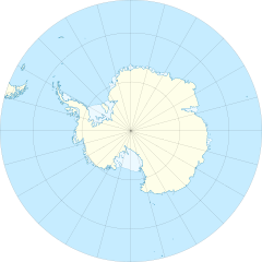
English: Location map of the Antarctic Ocean
|
| Datums | |
| Avots | Paša darbs |
| Autors | Tentotwo |
| Citas versijas |
|

Licence
Es, šī darba autortiesību īpašnieks, publicēju to saskaņā ar šo licenci:
Šis fails tiek izplatīts saskaņā ar licences Creative Commons Atsauce-Līdzīgi Noteikumi 3.0 Vispārējiem noteikumiem.
- Jūs varat brīvi:
- koplietot – kopēt, izplatīt un pārraidīt darbu
- remiksēt – pielāgot darbu
- Saskaņā ar šādiem nosacījumiem:
- atsaucoties – Tev ir jānorāda autors, saite uz licenci un to, vai veiktas kādas izmaiņas. To var darīt jebkādā saprātīgā veidā, bet ne tādā, kas norādītu, ka licencētājs atbalsta tevi vai veidu, kā tu izmanto šo darbu.
- nemainot licenci – Ja tu miksē, pārveido vai izmanto materiālu, tev savs devums jāpublicē ar to pašu vai saderīgu licenci kā oriģināls.
Shell script for generating the map using GMT archive copy at the Wayback Machine
#!/bin/sh

# Set common options
PROJECTION=E0.0/-90.0/20.0c
REGION=-180/180/-90/-50
FILENAME=Antarctic_Ocean_location_map.ps

# Get Natural Earth datafiles
echo "Downloading datafiles from naturalearthdata.com"
wget -nv -nc \
 http://www.naturalearthdata.com/http//www.naturalearthdata.com/download/50m/physical/50m-coastline.zip\
 http://www.naturalearthdata.com/http//www.naturalearthdata.com/download/50m/physical/50m-land.zip\
 http://www.naturalearthdata.com/http//www.naturalearthdata.com/download/50m/cultural/50m-admin-0-boundary-lines.zip\
 http://www.naturalearthdata.com/http//www.naturalearthdata.com/download/50m/physical/50m-antarctic-ice-shelves-polys.zip\
 http://www.naturalearthdata.com/http//www.naturalearthdata.com/download/50m/physical/50m-antarctic-ice-shelves-lines.zip
echo "...done\n"

echo "Inflating archives"
unzip 50m\*.zip
echo "...done\n"

echo "Converting shapefiles to GMT"
ogr2ogr -F GMT 50m_land.gmt 50m_land.shp
ogr2ogr -F GMT 50m_coastline.gmt 50m_coastline.shp
ogr2ogr -F GMT 50m_borders.gmt ne_50m_admin_0_boundary_lines_land.shp
ogr2ogr -F GMT 50m_ice.gmt 50m_antarctic_ice_shelves_polys.shp
ogr2ogr -F GMT 50m_ice_borders.gmt 50m_antarctic_ice_shelves_lines.shp
echo "...done\n"

echo "Creating maps"
GMT psxy -m -J$PROJECTION -R$REGION -Bg15 --POLAR_CAP=none --BASEMAP_TYPE=plain --BASEMAP_AXES=N --FRAME_PEN=0.15p,black 50m_land.gmt -K -G254/254/233 > $FILENAME
GMT psxy -m -J$PROJECTION -R$REGION 50m_ice.gmt -O -K -G236/249/255 >> $FILENAME
GMT psxy -m -J$PROJECTION -R$REGION 50m_coastline.gmt -O -K -W0.535p,9/120/171  >> $FILENAME
GMT psxy -m -J$PROJECTION -R$REGION 50m_ice_borders.gmt -O -K -W0.27p,9/120/171  >> $FILENAME
GMT psxy -m -J$PROJECTION -R$REGION 50m_borders.gmt -O -W100/100/100  >> $FILENAME
echo "...done\n"

echo "You can now open $FILENAME in Inkscape to clean up the file and save it as SVG. You should add an ocean coloured background and simplify the graticules using CTRL+L."
Faila hronoloģija
Uzklikšķini uz datums/laiks kolonnā esošās saites, lai apskatītos, kā šis fails izskatījās tad.
| Datums/Laiks | Attēls | Izmēri | Dalībnieks | Komentārs | |
|---|---|---|---|---|---|
| tagadējais | 2012. gada 27. janvāris, plkst. 16.46 | | 709 × 709 (243 KB) | Tentotwo |
Faila lietojums
Šo failu izmanto šajās 3 lapās:
Globālais faila lietojums
Šīs Vikipēdijas izmanto šo failu:
- Izmantojums az.wikipedia.org
- Izmantojums bg.wikipedia.org
- Izmantojums ce.wikipedia.org
- Izmantojums de.wikipedia.org
- Izmantojums en.wikisource.org
- User:EncycloPetey
- User talk:Zyephyrus
- User:Kathleen.wright5
- User:George Orwell III
- User:Magnus Manske
- User:William Maury Morris II
- User:Tannertsf
- User:Mpaa
- User:Beeswaxcandle/Works
- User:WeeJeeVee
- User:Slowking4
- User:Legofan94
- User:GreyHead
- User:Keith Edkins/Participation archive
- User:HueSatLum
- User:Pixelwarrior
- User:Denis Barthel
- User:WhatamIdoing
- User:Sushant savla
- User:EncycloPetey/Userboxes
- Izmantojums eo.wikipedia.org
- Izmantojums es.wikipedia.org
- Izmantojums fr.wikipedia.org
- Izmantojums gl.wikipedia.org
- Izmantojums hu.wikipedia.org
- Izmantojums hy.wikipedia.org
- Izmantojums ka.wikipedia.org
- Izmantojums kk.wikipedia.org
- Izmantojums pl.wikipedia.org
- Izmantojums pl.wikibooks.org
- Izmantojums pl.wiktionary.org
Skatīt šī faila pilno globālo izmantojumu.