
Attēls:Arrondissement Nivelles Belgium Map.png
Augstāka izšķirtspēja nav pieejama.
Arrondissement_Nivelles_Belgium_Map.png (190 × 95 pikseļi, faila izmērs: 2 KB, MIME tips: image/png)
| Šis fails ir no Vikikrātuves. Tā apraksts no attēla lapas Vikikrātuvē ir parādīts zemāk. Vikikrātuve ir brīvi licencēta failu krātuve. Tu vari tai palīdzēt. |
Kopsavilkums
| Apraksts |
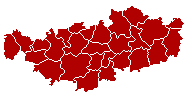
English: This map indicates (in red) the location of administrative and judicial arrondissements of Nivelles in the province of Brabant Wallon, Belgium. Both maps are the same and fill all the province of Brabant Wallon. In this case, a redirection is available at File:Judicial_Arrondissement_Nivelles_Belgium_Map.png for an easy and intuitive access to judicial arrondissement map. Colors changed based on work from w:nl:Gebruiker:LennartBolks/kaartenhoekje also in PD
Français : Cette carte indique (en rouge) la localisation de l'arrondissement administratif et judiciaire de Nivelles dans la Province de Brabant wallon, Belgique. Les deux cartes se confondent et occupent toute la province du Brabant wallon. De cette manière, une redirection est accessible à File:Judicial_Arrondissement_Nivelles_Belgium_Map.png pour un accès facile et intuitif à la carte de l'arrondissement judiciaire. Les couleurs sont basées sur le travail de w:nl:Gebruiker:LennartBolks/kaartenhoekje. |
| Avots | Paša darbs |
| Autors | LennartBolks |
Licence
| This work has been released into the public domain by its author, LennartBolks. This applies worldwide. In some countries this may not be legally possible; if so: |
Faila hronoloģija
Uzklikšķini uz datums/laiks kolonnā esošās saites, lai apskatītos, kā šis fails izskatījās tad.
| Datums/Laiks | Attēls | Izmēri | Dalībnieks | Komentārs | |
|---|---|---|---|---|---|
| tagadējais | 2005. gada 2. aprīlis, plkst. 12.27 | | 190 × 95 (2 KB) | Nicnac25~commonswiki | Map of Nivelles District in province of Brabant Wallon, Belgium FR; Carte indiquant la localisation de l'arrondissement de Nivelles dans la Province de Brabant wallon. {{PD}} colors changed by me, based on work from [[w:nl:Gebruiker:LennartBolks/kaartenh |
Faila lietojums
Šo failu izmanto šajā 1 lapā:
Globālais faila lietojums
Šīs Vikipēdijas izmanto šo failu:
- Izmantojums bg.wikipedia.org
- Izmantojums br.wikipedia.org
- Izmantojums bs.wikipedia.org
- Izmantojums ceb.wikipedia.org
- Izmantojums cs.wikipedia.org
- Izmantojums de.wikipedia.org
- Izmantojums de.wikivoyage.org
- Izmantojums fa.wikipedia.org
- Izmantojums fr.wikipedia.org
- Izmantojums gl.wikipedia.org
- Izmantojums hu.wikipedia.org
- Izmantojums it.wikipedia.org
- Izmantojums lb.wikipedia.org
- Izmantojums li.wikipedia.org
- Izmantojums nl.wikipedia.org
- Izmantojums no.wikipedia.org
- Izmantojums ru.wikipedia.org
- Izmantojums sv.wikipedia.org
- Izmantojums th.wikipedia.org
- Izmantojums vec.wikipedia.org
- Izmantojums vi.wikipedia.org
- Izmantojums vls.wikipedia.org
- Izmantojums wa.wikipedia.org