
Attēls:Crazywell cross 1.JPG

Šī priekšskata izmērs: 800 × 600 pikseļi. Citi izmēri: 320 × 240 pikseļi | 640 × 480 pikseļi | 1 024 × 768 pikseļi | 1 280 × 960 pikseļi | 2 048 × 1 536 pikseļi.
Sākotnējais fails (2 048 × 1 536 pikseļi, faila izmērs: 1,42 MB, MIME tips: image/jpeg)
| Šis fails ir no Vikikrātuves. Tā apraksts no attēla lapas Vikikrātuvē ir parādīts zemāk. Vikikrātuve ir brīvi licencēta failu krātuve. Tu vari tai palīdzēt. |
|

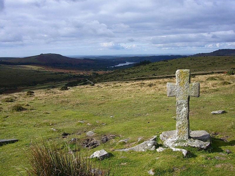
This image was selected as picture of the day on Wikimedia Commons for 8 June 2009. It was captioned as follows: English: Ancient cross close to Crazywell Pool on southern Dartmoor. Other languages:
Bahasa Indonesia: Salib tua di dekat kolam Crazywell di Dartmoor selatan, Inggris. Dansk: Gammelt kors nær Crazywell Pool i den sydlige del af Dartmoor nationalpark i Storbritannien. Deutsch: Steinkreuz im Dartmoor, Südwestengland English: Ancient cross close to Crazywell Pool on southern Dartmoor. Español: Cruz antigua cerca de Crazywell Pool, al sur de Dartmoor. Esperanto: antikva ŝtona kruco proksime al la lageto Crazywell Pool en la nacia parko Dartmoor en Britio Français : Ancienne croix près de l'étang de Crazywell, dans le sud du parc naturel du Dartmoor. Elle était vraisemblablement utilisée comme marque de balisage pour le chemin allant du monastère de Buckfast au monastère de Tavistock. Nederlands: oud kruis nabij de Crazywell Pool in het zuiden van de Dartmoor in het Engelse graafschap Devon Polski: Starodawny krzyż w pobliżu Crazywell Pool, na południe od Parku Narodowego Dartmoor Română: Cruce veche, lângă Crazywell Pool, în sudul Dartmoorului. Македонски: Древен крст близу Крејзивел Пул во јужен Дартмур. 한국어: 남부 다트무어 Crazywell Pool 가까운 곳에 위치한 고대 십자가 中文: 达特穆尔南部疯狂井池古老的十字架。 中文(繁體): 達特穆爾南部瘋狂井池古老的十字架。 |

|
This image has been assessed under the valued image criteria and is considered the most valued image on Commons within the scope: Dartmoor Crosses. You can see its nomination here. |
Kopsavilkums
| Apraksts |
English: Ancient cross close to Crazywell Pool on southern Dartmoor. It may well have been used as a marker for the track from the monastery at Buckfast to the monastery at Tavistock. Burrator reservoir can be seen in the distance.
Français : Ancienne croix près de l'étang de Crazywell, dans le sud du parc naturel du Dartmoor. Elle était vraisemblablement utilisée comme marque de balisage pour le chemin allant du monastère de Buckfast au monastère de Tavistock. Le lac réservoir de Burrator est visible à l'arrière-plan
Deutsch: Historisches Kreuz in der Nähe von Crazywell Pool im südlichen Dartmoor (Devon, UK). Möglicherweise wurde es als Wegweiser vom Kloster in Buckfast zum Kloster von Tavistock genutzt. Im Hintergrund ist das Wasserreservoir von Burrator zu erkennen. |
| Datums | 2008. gada 29. septembris (created) |
| Avots | Paša darbs |
| Autors | Myself – Herby talk thyme |
| Camera location | | View this and other nearby images on: OpenStreetMap |
|---|
Licence
Es, šī darba autortiesību īpašnieks, publicēju to saskaņā ar šīm licencēm:

|
Ir dota atļauja kopēt, izplatīt un/vai pārveidot šo dokumentu saskaņā ar GNU brīvās dokumentācijas licences, versijas 1.2 vai jebkuras vēlākas versijas, ko publiskojis Brīvās programmatūras fonds nosacījumiem; bez nemainīgajām sadaļā, priekšējā un aizmugurēja'vāka tekstiem. Licences kopija ir iekļauta sadaļā ar nosaukumu GNU brīvās dokumentācijas licence. |
This file is licensed under the Creative Commons Attribution-Share Alike Attribution-Share Alike 4.0 International, 3.0 Unported, 2.5 Generic, 2.0 Generic and 1.0 Generic license.
- Jūs varat brīvi:
- koplietot – kopēt, izplatīt un pārraidīt darbu
- remiksēt – pielāgot darbu
- Saskaņā ar šādiem nosacījumiem:
- atsaucoties – Tev ir jānorāda autors, saite uz licenci un to, vai veiktas kādas izmaiņas. To var darīt jebkādā saprātīgā veidā, bet ne tādā, kas norādītu, ka licencētājs atbalsta tevi vai veidu, kā tu izmanto šo darbu.
- nemainot licenci – Ja tu miksē, pārveido vai izmanto materiālu, tev savs devums jāpublicē ar to pašu vai saderīgu licenci kā oriģināls.
Jūs varat izvēlēties licenci pēc jūsu vēlmes.
Faila hronoloģija
Uzklikšķini uz datums/laiks kolonnā esošās saites, lai apskatītos, kā šis fails izskatījās tad.
| Datums/Laiks | Attēls | Izmēri | Dalībnieks | Komentārs | |
|---|---|---|---|---|---|
| tagadējais | 2008. gada 1. oktobris, plkst. 13.05 | | 2 048 × 1 536 (1,42 MB) | Herbythyme | {{Information| |Description = Ancient cross close to Crazywell Pool on southern Dartmoor. It may well have been used as a marker for the track from the monastery at Buckfast to the monastery at Tavistock. |Source = self-made |Date = c |
Faila lietojums
Šo failu izmanto šajā 1 lapā:
Globālais faila lietojums
Šīs Vikipēdijas izmanto šo failu:
- Izmantojums bg.wikipedia.org
- Izmantojums bn.wikipedia.org
- Izmantojums crh.wikipedia.org
- Izmantojums cv.wikipedia.org
- Izmantojums en.wikipedia.org
- Dartmoor
- South West England
- Crazywell Pool
- Wikipedia:WikiProject UK geography
- Wikipedia:Featured pictures/Places/Landscapes
- Wikipedia:Featured pictures thumbs/15
- User talk:Herbythyme/Arc4
- Wikipedia:Featured picture candidates/Crazywell Cross
- Dartmoor crosses
- Wikipedia:Featured picture candidates/February-2009
- Wikipedia:Wikipedia Signpost/2009-02-08/Features and admins
- Portal:England/Selected picture/04 2009
- User talk:Herbythyme/Arc5
- Wikipedia:Picture of the day/November 2009
- Template:POTD/2009-11-15
- Wikipedia:Did you know/Statistics/Monthly DYK pageview leaders/2009
- Wikipedia:Recent additions/2009/February
- User talk:Mbz1/Archive1
- Wikipedia:WikiProject Devon/Featured content
- Wikipedia:Wikipedia Signpost/2009-02-08/SPV
- Wikipedia:WikiProject England/The West Country Challenge
- Wikipedia:WikiProject England/The West Country Challenge/Devon
- User:Trans-Neptunian object
- Wikipedia:Wikipedia Signpost/Single/2009-02-08
- Izmantojums fi.wikipedia.org
- Izmantojums fr.wikipedia.org
- Izmantojums he.wikipedia.org
- Izmantojums hu.wikipedia.org
- Izmantojums it.wikipedia.org
- Izmantojums ko.wikipedia.org
- Izmantojums lbe.wikipedia.org
- Izmantojums lt.wikipedia.org
- Izmantojums mk.wikipedia.org
- Izmantojums ml.wikipedia.org
- Izmantojums nl.wikipedia.org
- Izmantojums os.wikipedia.org
- Izmantojums pl.wikipedia.org
- Izmantojums pl.wikivoyage.org
Skatīt šī faila pilno globālo izmantojumu.