
Attēls:Curonian Spit NP 05-2017 img03 aerial view at Muellers Height.jpg

Šī priekšskata izmērs: 800 × 500 pikseļi. Citi izmēri: 320 × 200 pikseļi | 640 × 400 pikseļi | 1 024 × 640 pikseļi | 1 280 × 800 pikseļi | 2 560 × 1 600 pikseļi | 4 396 × 2 747 pikseļi.
Sākotnējais fails (4 396 × 2 747 pikseļi, faila izmērs: 7,03 MB, MIME tips: image/jpeg)
| Šis fails ir no Vikikrātuves. Tā apraksts no attēla lapas Vikikrātuvē ir parādīts zemāk. Vikikrātuve ir brīvi licencēta failu krātuve. Tu vari tai palīdzēt. |
| Apraksts |
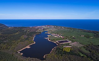
English: Curonian Spit in Kaliningrad Oblast (Russia). Aerial view at Müller's Height. View of Lake Chaika and Rybachiy settlement.
Deutsch: Kurische Nehrung im Kaliningrader Gebiet (Russland). Luftaufnahme an der Müller-Höhe. Aussicht auf Tschaika-See und Rybatschi/Rossitten.
Русский: Куршская коса в Калининградской области (Россия). Аэрофотосъёмка над высотой Мюллера. Вид на озеро Чайка и посёлок Рыбачий.
|
|||
| Datums | ||||
| Avots | Paša darbs | |||
| Autors | A.Savin | |||
| Atļauja: (Šī faila izmantošana citur) |
.svg) Just attribute the author: «A.Savin, Wikipedia»; if you have questions — Telegram, or e-mail to wikiphotospace@gmail.com..svg) Просто укажите в качестве автора: «А.Савин, Википедия»; если есть вопрос — телеграм, или эл.почта на wikiphotospace@gmail.com. Kennzeichnen Sie einfach als Autor: «A.Savin, Wikipedia»; falls Sie Fragen haben — Telegram, oder E-Mail an wikiphotospace@gmail.com.
Thank you. |
| Camera location | | View this and other nearby images on: OpenStreetMap |
|---|
Šis attēls tika augšupielādēts konkursa "Dabas skati Vikipēdijā 2017" ietvaros.
|
 |
Licence
| Copyleft: This work of art is free; you can redistribute it and/or modify it according to terms of the Free Art License. You will find a specimen of this license on the Copyleft Attitude site as well as on other sites. |
Faila hronoloģija
Uzklikšķini uz datums/laiks kolonnā esošās saites, lai apskatītos, kā šis fails izskatījās tad.
| Datums/Laiks | Attēls | Izmēri | Dalībnieks | Komentārs | |
|---|---|---|---|---|---|
| tagadējais | 2017. gada 22. maijs, plkst. 20.29 | | 4 396 × 2 747 (7,03 MB) | A.Savin | {{User:A.Savin/F |Description= {{en|Curonian Spit in Kaliningrad Oblast (Russia). Aerial view at Müller's Height. View of Lake Chaika and Rybachiy settlement.}} {{de|Kurische Nehrung im Kaliningrader Gebiet (Russland). Luftaufnahme an der Müller-Höh... |
Faila lietojums
Šo failu izmanto šajā 1 lapā:
Globālais faila lietojums
Šīs Vikipēdijas izmanto šo failu:
- Izmantojums de.wikipedia.org
- Izmantojums en.wikipedia.org
- Izmantojums es.wikipedia.org
- Izmantojums ko.wikipedia.org
- Izmantojums lt.wikipedia.org
- Izmantojums ru.wikipedia.org
- Izmantojums www.wikidata.org