
Attēls:Ethiopia, the Ogaden Region. LOC 91682434.jpg

Šī priekšskata izmērs: 800 × 506 pikseļi. Citi izmēri: 320 × 202 pikseļi | 640 × 405 pikseļi | 1 024 × 648 pikseļi | 1 280 × 810 pikseļi | 2 560 × 1 620 pikseļi | 6 747 × 4 269 pikseļi.
Sākotnējais fails (6 747 × 4 269 pikseļi, faila izmērs: 3,53 MB, MIME tips: image/jpeg)
| Šis fails ir no Vikikrātuves. Tā apraksts no attēla lapas Vikikrātuvē ir parādīts zemāk. Vikikrātuve ir brīvi licencēta failu krātuve. Tu vari tai palīdzēt. |
Kopsavilkums
| Apraksts |
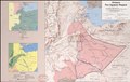
English: "504025 7-80." Relief shown by shading. Ancillary maps: Ethnic groups -- Vegetation. Available also through the Library of Congress Web site as a raster image. |
||
| Title | Ethiopia, the Ogaden Region. | ||
| Shelf ID | G8332.O4 1980 .U5 | ||
| Datums | |||
| Avots | https://www.loc.gov/item/91682434/ | ||
| Autors | United States. Central Intelligence Agency | ||
| Atļauja: (Šī faila izmantošana citur) |
|
||
| Citas versijas |
|
||
| Location | Ethiopia · Ogaden Region | ||
| Part of | American Memory · General Maps · Catalog · Geography And Map Division | ||
| Subject | Ethnology · Ethiopia · Ogaden Region (Ethiopia) · Maps · Ogaden Region · Phytogeography |

Licence
| This image is a work of a Central Intelligence Agency employee, taken or made as part of that person's official duties. As a Work of the United States Government, this image or media is in the public domain in the United States.
|

|
Faila hronoloģija
Uzklikšķini uz datums/laiks kolonnā esošās saites, lai apskatītos, kā šis fails izskatījās tad.
| Datums/Laiks | Attēls | Izmēri | Dalībnieks | Komentārs | |
|---|---|---|---|---|---|
| tagadējais | 2018. gada 9. septembris, plkst. 17.47 | | 6 747 × 4 269 (3,53 MB) | Fæ | LOC Maps https://www.loc.gov/item/91682434/ #18321 |
Faila lietojums
Šo failu izmanto šajā 1 lapā:
Globālais faila lietojums
Šīs Vikipēdijas izmanto šo failu: