
Attēls:Europa Germanen 50 n Chr.svg

Size of this PNG preview of this SVG file: 800 × 557 pikseļi. Citi izmēri: 320 × 223 pikseļi | 640 × 445 pikseļi | 1 024 × 713 pikseļi | 1 280 × 891 pikseļi | 2 560 × 1 782 pikseļi | 941 × 655 pikseļi.
Sākotnējais fails (SVG fails, definētais izmērs 941 × 655 pikseļi, faila izmērs: 710 KB)
| Šis fails ir no Vikikrātuves. Tā apraksts no attēla lapas Vikikrātuvē ir parādīts zemāk. Vikikrātuve ir brīvi licencēta failu krātuve. Tu vari tai palīdzēt. |
Belege
Es fehlen die zugrunde liegenden Quellenangaben für die Erstellung der Karte. --84.137.56.234 22:25, 19 January 2013 (UTC)
Kopsavilkums
| Apraksts |
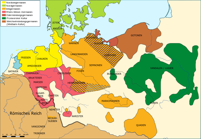
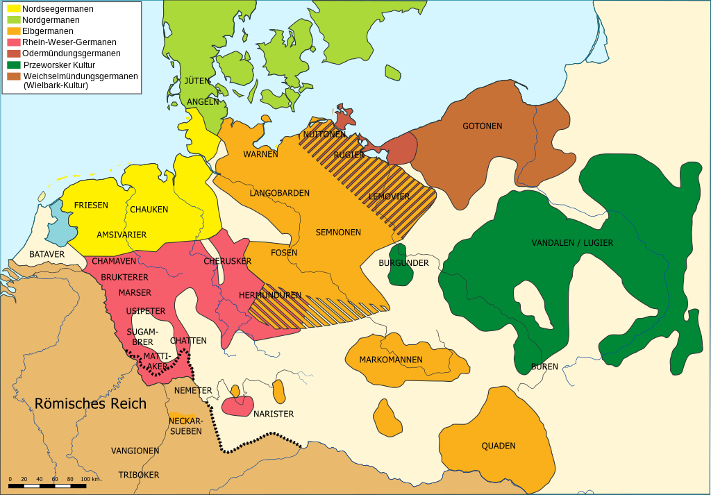
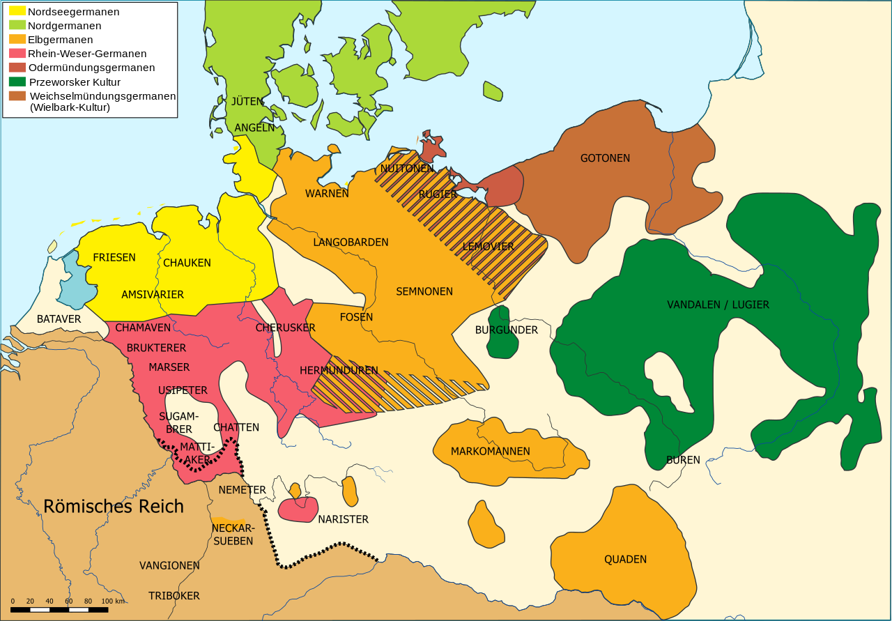
Deutsch: Die räumliche Verteilung germanischer Volksgruppen um 50 n. Chr. (siehe auch Germanen)
English: The distribution of Germanic ethnic groups during the first century AD
Français : Carte des peuples germaniques au 1er siècle après J.-C. |
| Datums | |
| Avots | Paša darbs |
| Autors | Karl Udo Gerth |
| Citas versijas |
Abgeleitete Werke dieser Datei:
|
| SVG veidošana |


Licence
| I, the copyright holder of this work, release this work into the public domain. This applies worldwide. In some countries this may not be legally possible; if so: I grant anyone the right to use this work for any purpose, without any conditions, unless such conditions are required by law. |
Faila hronoloģija
Uzklikšķini uz datums/laiks kolonnā esošās saites, lai apskatītos, kā šis fails izskatījās tad.
| Datums/Laiks | Attēls | Izmēri | Dalībnieks | Komentārs | |
|---|---|---|---|---|---|
| tagadējais | 2015. gada 11. maijs, plkst. 14.48 | | 941 × 655 (710 KB) | Furfur | Landfläche heller |
| 2015. gada 11. maijs, plkst. 14.06 |  | 941 × 655 (710 KB) | Furfur | Bildlegende etwas größer, Meer etwas heller | |
| 2014. gada 28. aprīlis, plkst. 20.08 |  | 941 × 655 (816 KB) | Hohum | Fixed key | |
| 2012. gada 14. februāris, plkst. 21.34 |  | 941 × 655 (816 KB) | Hohum | Less confusing colours. | |
| 2009. gada 25. novembris, plkst. 21.09 |  | 941 × 655 (782 KB) | KarlUdo | Sachsen nach Hinweis von [http://en.wikipedia.org/wiki/User:Trigaranus Trigaranus] entfernt. | |
| 2009. gada 29. janvāris, plkst. 19.04 |  | 1 176 × 819 (567 KB) | KarlUdo | {{Information |Description={{de|1=Die räumliche Verteilung germanischer Volksgruppen um 100 n. Chr. }} |Source=Eigenes Werk (own work) |Author=KarlUdo |Date=2009-01-29 |Permission= |other_versions= }} <!--{{ImageUpload|full}}--> [[Categ |
Faila lietojums
Šo failu neizmanto nevienā lapā.
Globālais faila lietojums
Šīs Vikipēdijas izmanto šo failu:
- Izmantojums af.wikipedia.org
- Izmantojums als.wikipedia.org
- Izmantojums az.wikipedia.org
- Izmantojums bg.wikipedia.org
- Izmantojums ca.wikipedia.org
- Izmantojums cs.wikipedia.org
- Izmantojums da.wikipedia.org
- Izmantojums de.wikipedia.org
- Germania (Tacitus)
- Ostfriesland
- 50
- Vandalen
- Cherusker
- Angelsachsen
- Markomannen
- Quaden
- Chauken
- Hermunduren
- Vangionen
- Markomannenkriege
- Rugier
- Warnen
- Mattiaker
- Ampsivarier
- Altendorf (Landkreis Bamberg)
- Triboker
- Wirmighausen
- Benutzer:Held in pantoffeln
- Benutzer:Alecconnell/Germania (Tacitus)
- Fosen (Stamm)
- Benutzer:KarlUdo/Bilder/Bildergalerie
- Benutzer:Tietjen/Vorlage:Vandalen
- Benutzer:Tietjen
- Benutzer:Frze
- Benutzer:Tommes/Babels
- Grünsberg (Altdorf bei Nürnberg)
- Wikipedia:Auskunft/Archiv/2014/Woche 16
- Neuses (Wendelstein)
- Schwarzach bei Schwabach
- Juliushof (Hirschaid)
- Untermainbach
- Benutzer:Sergeant Major Schlingell
- Izmantojums el.wikipedia.org
- Izmantojums en.wikipedia.org
Skatīt šī faila pilno globālo izmantojumu.