Attēls:Europe geological map-en.svg

Lapas saturs netiek atbalstīts citās valodās.
Vikipēdijas lapa

Sākotnējais fails(SVG fails, definētais izmērs 5 408 × 5 504 pikseļi, faila izmērs: 28,8 MB)

Kopsavilkums

Apraksts
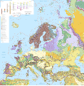
English: Map in English of the surficial geology of Europe.

Notes:

  • The background map is a raster PNG image embedded in the SVG file.
  • Due to its heavy file-weight, this version is only intended to be used for working purposes like translations. For use in article pages consider the JPEG version.
  • Each geology province is classified and named in the XML code of the SVG file.
  • A list of the names corresponding to the geologic provinces codes displayed on the map can be viewed on the discussion page.


Français : Carte en anglais de la géologie de surface de l'Europe.

Notes :

  • Le fond de carte est une image bitmap PNG embarquée dans le fichier SVG.
  • En raison du poids important du fichier, cette carte n'est destinée qu'aux travaux, comme par exemple les traductions. Pour l'utilisation dans les pages d'articles préférer la version JPEG.
  • Chaque province géologique est classée et nommée dans le code XML du fichier SVG.
  • Une liste des noms anglophones correspondant aux codes des provinces géologiques de la carte peut être consultée sur la page de discussion.

Lambert Azimuthal Equal-Area projection - ETRS89 datum

Scale 1:5,000,000
Datums
Avots

Paša darbs

  • Sources of data:
    • USGS (public domain for the part of the data used)
    • International political boundaries and additional coastlines: NGDC World Coast Line (public domain)
Autors Eric Gaba (Sting - fr:Sting)
Atļauja:
(Šī faila izmantošana citur)
Attribution and Share-Alike required
Citas versijas


Translate this file This SVG file contains embedded text that can be translated into your language, using any capable SVG editor, text editor or the SVG Translate tool. For more information see: About translating SVG files.

Licence

Eric Gaba, Wikimedia Commons user Sting, šī darba autortiesību īpašnieks, publicē to saskaņā ar šo licenci:
w:en:Creative Commons
atsaucoties nemainot licenci
Šis fails tiek izplatīts saskaņā ar licences Creative Commons Atsauce-Līdzīgi Noteikumi 3.0 Vispārējiem noteikumiem.
Atsauce: Eric Gaba, Wikimedia Commons user Sting
Jūs varat brīvi:
  • koplietot – kopēt, izplatīt un pārraidīt darbu
  • remiksēt – pielāgot darbu
Saskaņā ar šādiem nosacījumiem:
  • atsaucoties – Tev ir jānorāda autors, saite uz licenci un to, vai veiktas kādas izmaiņas. To var darīt jebkādā saprātīgā veidā, bet ne tādā, kas norādītu, ka licencētājs atbalsta tevi vai veidu, kā tu izmanto šo darbu.
  • nemainot licenci – Ja tu miksē, pārveido vai izmanto materiālu, tev savs devums jāpublicē ar to pašu vai saderīgu licenci kā oriģināls.

Captions

Pievieno vienas rindiņas aprakstu, ko šis fails attēlo

Šajā failā attēlotais

attēlo

augusts 2010

Faila hronoloģija

Uzklikšķini uz datums/laiks kolonnā esošās saites, lai apskatītos, kā šis fails izskatījās tad.

Datums/LaiksAttēlsIzmēriDalībnieksKomentārs
tagadējais2010. gada 13. augusts, plkst. 20.482010. gada 13. augusts, plkst. 20.48 versijas sīktēls5 408 × 5 504 (28,8 MB)Sting== {{int:filedesc}} == {{Location|60|00|00|N|20|00|00|E|scale:20000000}} <br/> {{Information| |Description={{en|Map in English of the surficial geology of Europe.<br/>''Notes: The background map is a raster PNG image embedded in

Šo failu izmanto šajā 1 lapā:

Globālais faila lietojums

Šīs Vikipēdijas izmanto šo failu: