
Attēls:Gps-multipath-efect.png

Augstāka izšķirtspēja nav pieejama.
Gps-multipath-efect.png (600 × 386 pikseļi, faila izmērs: 513 KB, MIME tips: image/png)
| Šis fails ir no Vikikrātuves. Tā apraksts no attēla lapas Vikikrātuvē ir parādīts zemāk. Vikikrātuve ir brīvi licencēta failu krātuve. Tu vari tai palīdzēt. |
| Apraksts |
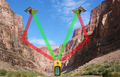
English: Multipath efect in GPS signal. Green color indicates the direct path of the waves, the red color indicates reflected waves.
Español: Efecto multitrayecto de la señal GPS. El color verde indica el trayecto directo de las ondas, el rojo las ondas reflejadas. |
| Datums | |
| Avots |
|
| Autors | derivative work: Javiersanp |
| Citas versijas |
|
| This is a retouched picture, which means that it has been digitally altered from its original version. Modifications: Collage. The original can be viewed here: Canyon midday.jpg:
|
Šis fails tiek izplatīts saskaņā ar licences Creative Commons Atsauce-Līdzīgi Noteikumi 3.0 Vispārējiem noteikumiem.
- Jūs varat brīvi:
- koplietot – kopēt, izplatīt un pārraidīt darbu
- remiksēt – pielāgot darbu
- Saskaņā ar šādiem nosacījumiem:
- atsaucoties – Tev ir jānorāda autors, saite uz licenci un to, vai veiktas kādas izmaiņas. To var darīt jebkādā saprātīgā veidā, bet ne tādā, kas norādītu, ka licencētājs atbalsta tevi vai veidu, kā tu izmanto šo darbu.
- nemainot licenci – Ja tu miksē, pārveido vai izmanto materiālu, tev savs devums jāpublicē ar to pašu vai saderīgu licenci kā oriģināls.
Original upload log
This image is a derivative work of the following images:
- File:GPS tracking satellites.jpg licensed with Cc-by-sa-2.5,2.0,1.0, Cc-by-sa-3.0-migrated, GFDL
- 2007-04-21T06:19:59Z Theonlysilentbob 1536x2048 (385521 Bytes) == Summary == {{Information |Description = Garmin eTrex Yellow GPS acquiring satellite signal |Source = Not Applicable |Date = April 21st 2007 |Author = Vaughan Weather |Permission = Anyone can use and freely distribute this
- File:Navstar-2.jpg licensed with PD-USGov-Military-Air Force
- 2005-03-26T18:06:36Z GDK 400x400 (20897 Bytes) NAVSTAR-2 (GPS-2) satellite Source: http://www.jpl.nasa.gov/images/grace/grace_083002_browse.jpg Status: PD-USGov-Military-Air Force {{PD-USGov-Military-Air Force}} [[Category:Satellites]]
- File:Canyon midday.jpg licensed with Cc-by-sa-3.0-migrated, GFDL
- 2008-04-29T11:50:09Z Movieevery 2272x1566 (1693780 Bytes) cropped
- 2008-01-03T19:54:12Z Gridge 2272x1704 (1279497 Bytes) {{Information |Description=A picture of the Marble Canyon section of the Grand Canyon, from river-level. |Source=Originally from [http://en.wikipedia.org en.wikipedia]; description page is/was [http://en.wikipedia.org/wiki/Im
Uploaded with derivativeFX
Faila hronoloģija
Uzklikšķini uz datums/laiks kolonnā esošās saites, lai apskatītos, kā šis fails izskatījās tad.
| Datums/Laiks | Attēls | Izmēri | Dalībnieks | Komentārs | |
|---|---|---|---|---|---|
| tagadējais | 2010. gada 9. aprīlis, plkst. 16.50 | | 600 × 386 (513 KB) | Javiersanp | {{Information |Description={{en|1=Multipath efect in GPS signal. Green color indicates the direct path of the waves, the red color indicates reflected waves.}} {{es|1=Efecto multitrayecto de la señal GPS. El color verde indica el trayecto directo de las |
Faila lietojums
Šo failu izmanto šajās 2 lapās:
Globālais faila lietojums
Šīs Vikipēdijas izmanto šo failu:
- Izmantojums en.wikipedia.org
- Izmantojums he.wikipedia.org