
Attēls:Hampshire UK locator map 2010.svg

Size of this PNG preview of this SVG file: 494 × 600 pikseļi. Citi izmēri: 198 × 240 pikseļi | 395 × 480 pikseļi | 633 × 768 pikseļi | 843 × 1 024 pikseļi | 1 687 × 2 048 pikseļi | 1 108 × 1 345 pikseļi.
Sākotnējais fails (SVG fails, definētais izmērs 1 108 × 1 345 pikseļi, faila izmērs: 302 KB)
| Šis fails ir no Vikikrātuves. Tā apraksts no attēla lapas Vikikrātuvē ir parādīts zemāk. Vikikrātuve ir brīvi licencēta failu krātuve. Tu vari tai palīdzēt. |
Kopsavilkums
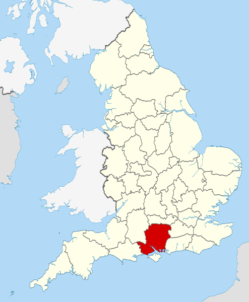
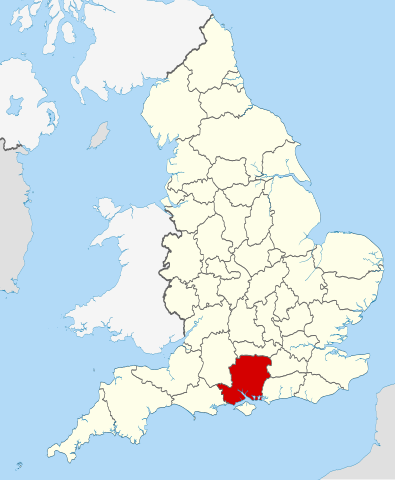
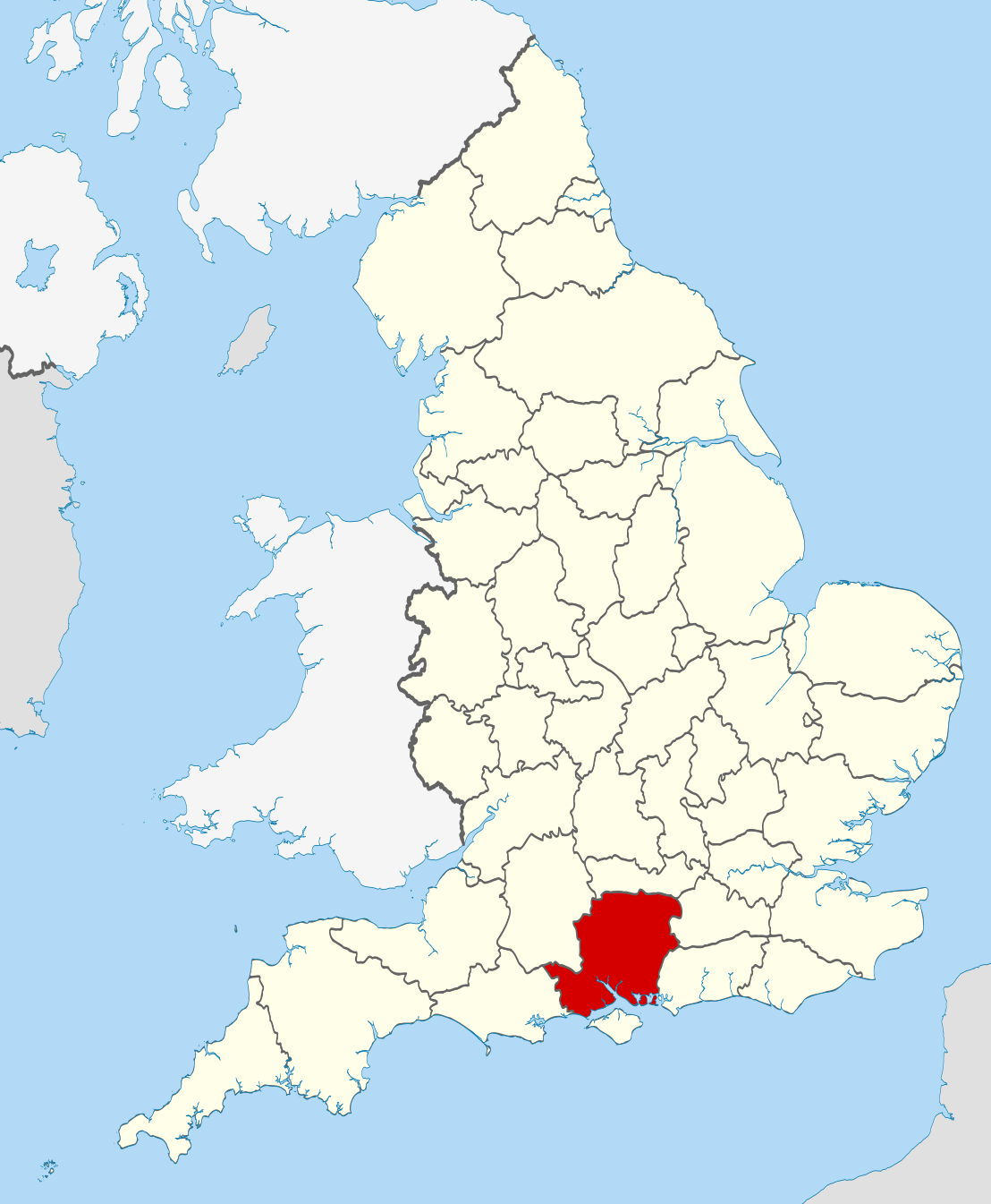
| Apraksts | Location of the ceremonial county of Hampshire within England. |
| Datums | |
| Avots |
National Geospatial-Intelligence Agency
|
| Autors | Nilfanion |
Licence
Es, šī darba autortiesību īpašnieks, publicēju to saskaņā ar šīm licencēm:
Šis fails tiek izplatīts saskaņā ar licences Creative Commons Atsauce-Līdzīgi Noteikumi 3.0 Vispārējiem noteikumiem.
- Jūs varat brīvi:
- koplietot – kopēt, izplatīt un pārraidīt darbu
- remiksēt – pielāgot darbu
- Saskaņā ar šādiem nosacījumiem:
- atsaucoties – Tev ir jānorāda autors, saite uz licenci un to, vai veiktas kādas izmaiņas. To var darīt jebkādā saprātīgā veidā, bet ne tādā, kas norādītu, ka licencētājs atbalsta tevi vai veidu, kā tu izmanto šo darbu.
- nemainot licenci – Ja tu miksē, pārveido vai izmanto materiālu, tev savs devums jāpublicē ar to pašu vai saderīgu licenci kā oriģināls.

|
Ir dota atļauja kopēt, izplatīt un/vai pārveidot šo dokumentu saskaņā ar GNU brīvās dokumentācijas licences, versijas 1.2 vai jebkuras vēlākas versijas, ko publiskojis Brīvās programmatūras fonds nosacījumiem; bez nemainīgajām sadaļā, priekšējā un aizmugurēja'vāka tekstiem. Licences kopija ir iekļauta sadaļā ar nosaukumu GNU brīvās dokumentācijas licence. |
Jūs varat izvēlēties licenci pēc jūsu vēlmes.

|
This is one of the images forming part of the Valued image set: Locator maps of the Ceremonial counties of England on Wikimedia Commons. The image set has been assessed under the valued image set criteria and is considered the most valued set on Commons within the scope:
Locator maps of the Ceremonial counties of England
You can see its nomination at Commons:Valued image candidates/Locator maps of English ceremonial counties. |
Faila hronoloģija
Uzklikšķini uz datums/laiks kolonnā esošās saites, lai apskatītos, kā šis fails izskatījās tad.
| Datums/Laiks | Attēls | Izmēri | Dalībnieks | Komentārs | |
|---|---|---|---|---|---|
| tagadējais | 2010. gada 24. novembris, plkst. 01.37 | | 1 108 × 1 345 (302 KB) | Nilfanion | == Summary == {{Information |Description=Location of the ceremonial county of Hampshire within England. |Source=Ordnance Survey [https://www.ordnancesurvey.co.uk/opendatadownload/products.html OpenData]: *County bound |
Faila lietojums
Šo failu izmanto šajās 2 lapās:
Globālais faila lietojums
Šīs Vikipēdijas izmanto šo failu:
- Izmantojums af.wikipedia.org
- Izmantojums ar.wikipedia.org
- Izmantojums ast.wikipedia.org
- Izmantojums be-tarask.wikipedia.org
- Izmantojums bg.wikipedia.org
- Izmantojums ca.wikipedia.org
- Izmantojums ceb.wikipedia.org
- Izmantojums cs.wikipedia.org
- Izmantojums dag.wikipedia.org
- Izmantojums en.wikipedia.org
- Hampshire
- Lovedean
- Bramdean Common
- Matley Bog
- Spithead
- Mengham
- Tourner Bury
- Hill Head
- Fratton
- Appleshaw
- Hart Plain
- Coombe, Hampshire
- Easton, Hampshire
- Freefolk
- Turgis Green
- Hambledon, Hampshire
- Avon Valley Path
- Clarendon Way
- King's Way
- Pilgrims' Trail
- Bentley, Hampshire
- Hangers Way
- Three Castles Path
- Strawberry Trail
- Soberton and Newtown Millennium Walk 2000
- Sutton Scotney
- Castleman Trailway
- Blackwater Valley Path
- Pilot Hill, Hampshire
- Queen Elizabeth Country Park
- North Waltham
- Cliddesden
- Baybridge, Hampshire
- Farther Common
- Lychpit
- Spanish Green
- Template:Hampshire-geo-stub
- Abbots Worthy
- Litchfield, Hampshire
Skatīt šī faila pilno globālo izmantojumu.