
Attēls:Lakechad map.png
Lakechad_map.png (588 × 362 pikseļi, faila izmērs: 38 KB, MIME tips: image/png)
| Šis fails ir no Vikikrātuves. Tā apraksts no attēla lapas Vikikrātuvē ir parādīts zemāk. Vikikrātuve ir brīvi licencēta failu krātuve. Tu vari tai palīdzēt. |
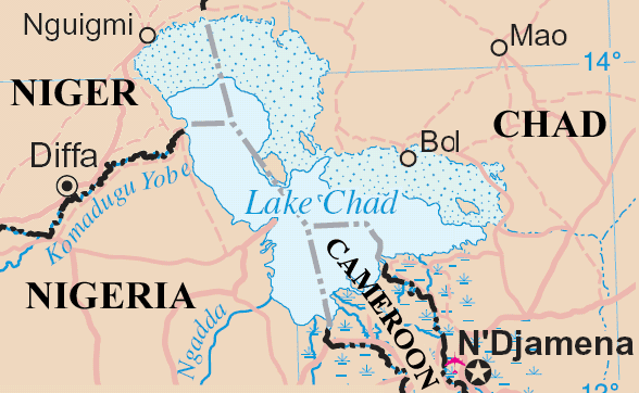
Lake Chad and surrounding area
Map adapted from http://www.un.org/Depts/Cartographic/map/profile/niger.pdf
| This image is a map derived from a United Nations map.
Unless stated otherwise, UN maps are to be considered in the public domain. This applies worldwide. UN maps are, in principle, open source material and you can use them in your work or for making your own map. UN requests however that you delete the UN name, logo and reference number upon any modification to the map. Content of your map will be your responsibility. You can state in your publication, if you wish, something like: based on UN map … (map name, map number, revision number and date). See: Geospatial Information Section. And: Geospatial, location data for a better world. |
 |
Faila hronoloģija
Uzklikšķini uz datums/laiks kolonnā esošās saites, lai apskatītos, kā šis fails izskatījās tad.
| Datums/Laiks | Attēls | Izmēri | Dalībnieks | Komentārs | |
|---|---|---|---|---|---|
| tagadējais | 2006. gada 23. maijs, plkst. 19.20 | | 588 × 362 (38 KB) | Amcaja | Lake Chad and surrounding area Map adapted from http://www.un.org/Depts/Cartographic/map/profile/niger.pdf {{UN map}} Category:Maps Category:Maps of Cameroon |
Faila lietojums
Šo failu neizmanto nevienā lapā.
Globālais faila lietojums
Šīs Vikipēdijas izmanto šo failu:
- Izmantojums af.wikipedia.org
- Izmantojums an.wikipedia.org
- Izmantojums ar.wikipedia.org
- Izmantojums bn.wikipedia.org
- Izmantojums cy.wikipedia.org
- Izmantojums el.wikipedia.org
- Izmantojums en.wikipedia.org
- Izmantojums es.wikipedia.org
- Izmantojums fa.wikipedia.org
- Izmantojums fi.wikipedia.org
- Izmantojums fr.wikipedia.org
- Izmantojums fy.wikipedia.org
- Izmantojums he.wikipedia.org
- Izmantojums hr.wikipedia.org
- Izmantojums id.wikipedia.org
- Izmantojums incubator.wikimedia.org
- Izmantojums io.wikipedia.org
- Izmantojums ja.wikipedia.org
- Izmantojums ka.wikipedia.org
- Izmantojums kcg.wikipedia.org
- Izmantojums ko.wikipedia.org
- Izmantojums la.wikipedia.org
- Izmantojums lb.wikipedia.org
- Izmantojums lt.wikipedia.org
- Izmantojums mg.wikipedia.org
- Izmantojums mn.wikipedia.org
- Izmantojums ms.wikipedia.org
- Izmantojums mt.wikipedia.org
- Izmantojums my.wikipedia.org
- Izmantojums nds-nl.wikipedia.org
- Izmantojums nl.wikipedia.org
- Izmantojums no.wikipedia.org
- Izmantojums oc.wikipedia.org
- Izmantojums pa.wikipedia.org
- Izmantojums pt.wikipedia.org
- Izmantojums qu.wikipedia.org
- Izmantojums ro.wikipedia.org
- Izmantojums sc.wikipedia.org
- Izmantojums sh.wikipedia.org
- Izmantojums simple.wikipedia.org
- Izmantojums si.wikipedia.org
- Izmantojums sk.wikipedia.org
Skatīt šī faila pilno globālo izmantojumu.