
Attēls:Møns Klint 5.jpg

Sākotnējais fails (2 387 × 1 690 pikseļi, faila izmērs: 2,45 MB, MIME tips: image/jpeg)
| Šis fails ir no Vikikrātuves. Tā apraksts no attēla lapas Vikikrātuvē ir parādīts zemāk. Vikikrātuve ir brīvi licencēta failu krātuve. Tu vari tai palīdzēt. |
Kopsavilkums
| Apraksts |
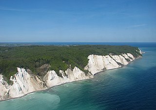
Deutsch: Ein Luftfoto von Møns Klint in Dänemark. In der Mitte sieht man Maglevands Fald mit Dronningestolen rechts. English: An aerial photo of Møns Klint (the Cliffs of Møn) in Denmark. Maglevands Fald is seen in the middle, with Dronningestolen on the right. |
||||
| Datums | |||||
| Avots | Paša darbs | ||||
| Autors | Bob Collowan | ||||
| Atļauja: (Šī faila izmantošana citur) |
|
||||

| Object location | | View this and other nearby images on: OpenStreetMap |
|---|
Licence
- Jūs varat brīvi:
- koplietot – kopēt, izplatīt un pārraidīt darbu
- remiksēt – pielāgot darbu
- Saskaņā ar šādiem nosacījumiem:
- atsaucoties – Tev ir jānorāda autors, saite uz licenci un to, vai veiktas kādas izmaiņas. To var darīt jebkādā saprātīgā veidā, bet ne tādā, kas norādītu, ka licencētājs atbalsta tevi vai veidu, kā tu izmanto šo darbu.
- nemainot licenci – Ja tu miksē, pārveido vai izmanto materiālu, tev savs devums jāpublicē ar to pašu vai saderīgu licenci kā oriģināls.
| Annotations | This image is annotated: View the annotations at Commons |

|
This is one of the images forming part of the Valued image set: Møns Klint (the Cliffs of Møn) on Wikimedia Commons. The image set has been assessed under the valued image set criteria and is considered the most valued set on Commons within the scope:
Møns Klint (the Cliffs of Møn)
You can see its nomination at Commons:Valued image candidates/Møns Klint. |
Faila hronoloģija
Uzklikšķini uz datums/laiks kolonnā esošās saites, lai apskatītos, kā šis fails izskatījās tad.
| Datums/Laiks | Attēls | Izmēri | Dalībnieks | Komentārs | |
|---|---|---|---|---|---|
| tagadējais | 2014. gada 21. jūnijs, plkst. 19.10 | | 2 387 × 1 690 (2,45 MB) | Bob Collowân | Straightened horizon |
| 2013. gada 4. jūlijs, plkst. 14.35 |  | 2 386 × 1 578 (2,5 MB) | Bob Collowân | User created page with UploadWizard |
Faila lietojums
Šo failu izmanto šajās 2 lapās:
Globālais faila lietojums
Šīs Vikipēdijas izmanto šo failu:
- Izmantojums cs.wikipedia.org
- Izmantojums da.wikipedia.org
- Izmantojums de.wikivoyage.org
- Izmantojums en.wikipedia.org
- Izmantojums is.wikipedia.org
- Izmantojums ko.wikipedia.org
- Izmantojums pl.wikivoyage.org
- Izmantojums pt.wikipedia.org
- Izmantojums th.wikipedia.org