
Attēls:Map-of-southeast-asia 900 CE.png
Šī priekšskata izmērs: 426 × 600 pikseļi. Citi izmēri: 170 × 240 pikseļi | 341 × 480 pikseļi | 791 × 1 114 pikseļi.
Sākotnējais fails (791 × 1 114 pikseļi, faila izmērs: 182 KB, MIME tips: image/png)
| Šis fails ir no Vikikrātuves. Tā apraksts no attēla lapas Vikikrātuvē ir parādīts zemāk. Vikikrātuve ir brīvi licencēta failu krātuve. Tu vari tai palīdzēt. |
khmerempire3.jpg
Kopsavilkums
| Apraksts |
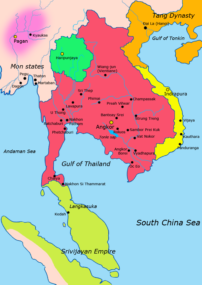
English: Map of Southeast Asia circa 900 CE, showing the Khmer Empire in red, Champa in yellow and Haripunjaya in light Green plus additional surrounding states.
sources i used for this work include http://ecaimaps.berkeley.edu/animations/2003_03_khmer_animation.swf http://www.britannica.com/EBchecked/media/3395/Khmer-empire-1200 Atlas of world history, Patrick Karl O'brien Societies, Networks, and Transitions: A Global History, Volume B. Craig A.Lockard http://upload.wikimedia.org/wikipedia/commons/thumb/4/45/Srivijaya_Empire.svg/2000px-Srivijaya_Empire.svg.png File:DvaravatiMapThailand.png http://upload.wikimedia.org/wikipedia/commons/e/eb/Thailand_2002_CIA_map.jpgBahasa Indonesia: Peta Asia Tenggara sekitar tahun 900 M, menampilkan Kerajaan Khmer dengan warna merah, Champa dengan warna kuning dan Haripunjaya dengan warna hijau beserta beberapa negara-negara lainnya. |
|||
| Datums | ||||
| Avots | Paša darbs | |||
| Autors | Javierfv1212 | |||
| Citas versijas |
|


Licence
Es, šī darba autortiesību īpašnieks, publicēju to saskaņā ar šo licenci:
| This file is made available under the Creative Commons CC0 1.0 Universal Public Domain Dedication. | |
| The person who associated a work with this deed has dedicated the work to the public domain by waiving all of their rights to the work worldwide under copyright law, including all related and neighboring rights, to the extent allowed by law. You can copy, modify, distribute and perform the work, even for commercial purposes, all without asking permission.
|
Faila hronoloģija
Uzklikšķini uz datums/laiks kolonnā esošās saites, lai apskatītos, kā šis fails izskatījās tad.
| Datums/Laiks | Attēls | Izmēri | Dalībnieks | Komentārs | |
|---|---|---|---|---|---|
| tagadējais | 2011. gada 8. aprīlis, plkst. 17.13 | | 791 × 1 114 (182 KB) | Ras67 | cropped |
| 2011. gada 28. marts, plkst. 05.13 |  | 800 × 1 125 (222 KB) | Javierfv1212 | {{Information |Description ={{en|1=Map of South-east asia circa 900 CE, showing the Khmer Empire in red, Champa in yellow and Haripunjaya in light Green plus additional surrounding states. sources i used for this work include http://ecaimaps.berkele |
Faila lietojums
Šo failu neizmanto nevienā lapā.
Globālais faila lietojums
Šīs Vikipēdijas izmanto šo failu:
- Izmantojums af.wikipedia.org
- Izmantojums ar.wikipedia.org
- Izmantojums azb.wikipedia.org
- Izmantojums az.wikipedia.org
- Izmantojums bg.wikipedia.org
- Izmantojums ca.wikipedia.org
- Izmantojums ceb.wikipedia.org
- Izmantojums cs.wikipedia.org
- Izmantojums el.wikipedia.org
- Izmantojums en.wikipedia.org
- Izmantojums eo.wikipedia.org
- Izmantojums et.wikipedia.org
- Izmantojums eu.wikipedia.org
- Izmantojums fa.wikipedia.org
- Izmantojums fi.wikipedia.org
- Izmantojums fr.wikipedia.org
- Izmantojums gu.wikipedia.org
- Izmantojums he.wikipedia.org
- Izmantojums id.wikipedia.org
- Izmantojums it.wikipedia.org
- Izmantojums ja.wikipedia.org
- Izmantojums ka.wikipedia.org
- Izmantojums km.wikipedia.org
- Izmantojums lo.wikipedia.org
- Izmantojums lt.wikipedia.org
- Izmantojums mg.wikipedia.org
- Izmantojums ml.wikipedia.org
- Izmantojums mn.wikipedia.org
Skatīt šī faila pilno globālo izmantojumu.