
Attēls:Map Crusader states 1190-en.svg

Size of this PNG preview of this SVG file: 441 × 600 pikseļi. Citi izmēri: 176 × 240 pikseļi | 353 × 480 pikseļi | 565 × 768 pikseļi | 753 × 1 024 pikseļi | 1 506 × 2 048 pikseļi | 978 × 1 330 pikseļi.
Sākotnējais fails (SVG fails, definētais izmērs 978 × 1 330 pikseļi, faila izmērs: 470 KB)
| Šis fails ir no Vikikrātuves. Tā apraksts no attēla lapas Vikikrātuvē ir parādīts zemāk. Vikikrātuve ir brīvi licencēta failu krātuve. Tu vari tai palīdzēt. |
Kopsavilkums
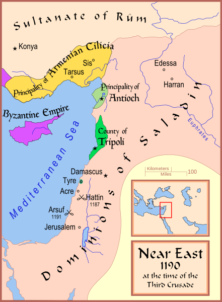
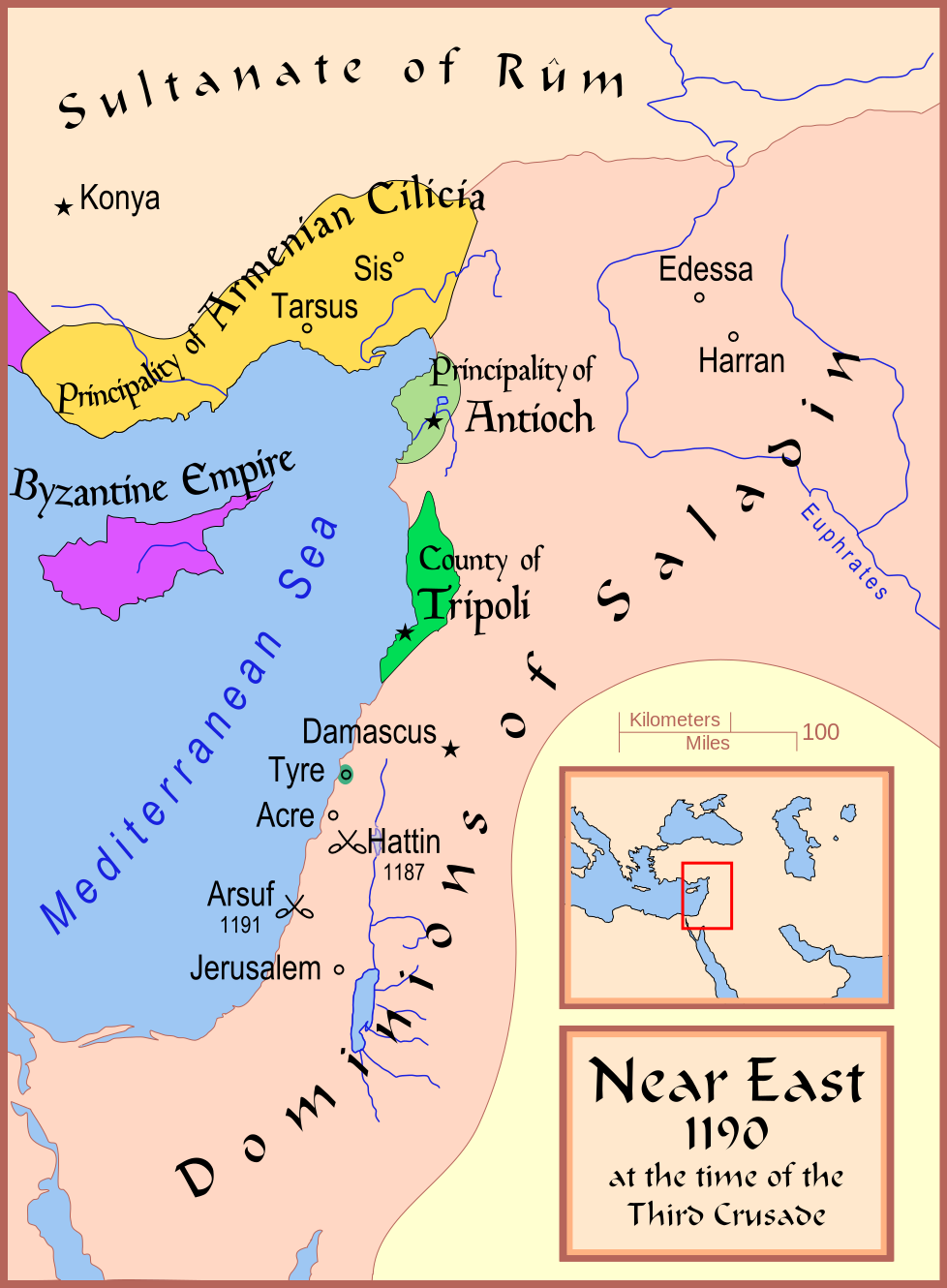
| Apraksts | A map showing the Near East (the Levant) in 1190. |
| Datums | |
| Avots | Paša darbs |
| Autors | MapMaster |
| Citas versijas |
[]
See also |


References
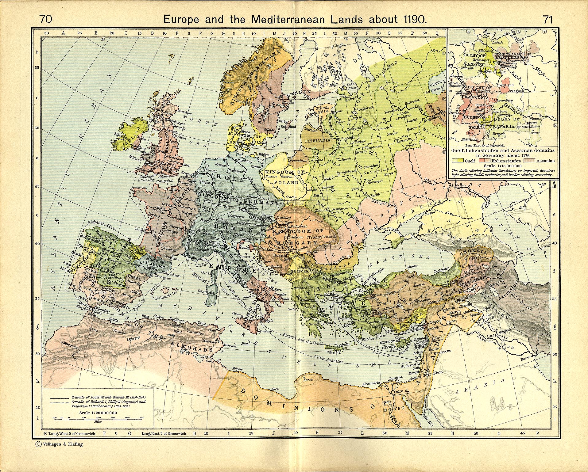
- Shepherd, William R. (1911) "Europe and the Mediterranean Lands about 1190"
Licence
Es, šī darba autortiesību īpašnieks, publicēju to saskaņā ar šīm licencēm:

|
Ir dota atļauja kopēt, izplatīt un/vai pārveidot šo dokumentu saskaņā ar GNU brīvās dokumentācijas licences, versijas 1.2 vai jebkuras vēlākas versijas, ko publiskojis Brīvās programmatūras fonds nosacījumiem; bez nemainīgajām sadaļā, priekšējā un aizmugurēja'vāka tekstiem. Licences kopija ir iekļauta sadaļā ar nosaukumu GNU brīvās dokumentācijas licence. |
This file is licensed under the Creative Commons Attribution-Share Alike 4.0 International, 3.0 Unported, 2.5 Generic, 2.0 Generic and 1.0 Generic license.
- Jūs varat brīvi:
- koplietot – kopēt, izplatīt un pārraidīt darbu
- remiksēt – pielāgot darbu
- Saskaņā ar šādiem nosacījumiem:
- atsaucoties – Tev ir jānorāda autors, saite uz licenci un to, vai veiktas kādas izmaiņas. To var darīt jebkādā saprātīgā veidā, bet ne tādā, kas norādītu, ka licencētājs atbalsta tevi vai veidu, kā tu izmanto šo darbu.
- nemainot licenci – Ja tu miksē, pārveido vai izmanto materiālu, tev savs devums jāpublicē ar to pašu vai saderīgu licenci kā oriģināls.
Jūs varat izvēlēties licenci pēc jūsu vēlmes.
Faila hronoloģija
Uzklikšķini uz datums/laiks kolonnā esošās saites, lai apskatītos, kā šis fails izskatījās tad.
| Datums/Laiks | Attēls | Izmēri | Dalībnieks | Komentārs | |
|---|---|---|---|---|---|
| tagadējais | 2008. gada 13. februāris, plkst. 20.35 | | 978 × 1 330 (470 KB) | MapMaster | Slight changes |
| 2008. gada 13. februāris, plkst. 20.28 |  | 978 × 1 330 (464 KB) | MapMaster | {{Information |Description=A map showing the Near East (the Levant) in 1190. |Source=self-made |Date=12 Feb 2008 |Author= MapMaster |Permission= |other_versions=see below }} ==Other versions== *[[:Image:Die Levante 1135 |
Faila lietojums
Šo failu izmanto šajā 1 lapā:
Globālais faila lietojums
Šīs Vikipēdijas izmanto šo failu:
- Izmantojums arz.wikipedia.org
- Izmantojums azb.wikipedia.org
- Izmantojums az.wikipedia.org
- Izmantojums be.wikipedia.org
- Izmantojums bg.wikipedia.org
- Izmantojums br.wikipedia.org
- Izmantojums ckb.wikipedia.org
- Izmantojums da.wikipedia.org
- Izmantojums de.wikipedia.org
- Izmantojums el.wikipedia.org
- Izmantojums en.wikipedia.org
- Kingdom of Jerusalem
- Richard I of England
- 1190
- Third Crusade
- Guy of Lusignan
- Battle of Arsuf
- Conrad of Montferrat
- Crusader states
- Krak des Chevaliers
- Siege of Acre (1189–1191)
- Bohemond III of Antioch
- Bohemond IV of Antioch
- Talk:Battle of Hattin
- Crusades
- Timeline of the Kingdom of Jerusalem
- Timeline of the Principality of Antioch
- User:Falcaorib
- Fall of Outremer
- Izmantojums et.wikipedia.org
- Izmantojums fi.wikipedia.org
- Izmantojums he.wikipedia.org
- Izmantojums hr.wikipedia.org
- Izmantojums hu.wikipedia.org
- Izmantojums hy.wikipedia.org
Skatīt šī faila pilno globālo izmantojumu.