
Attēls:Map of the Grand Duchy of Lithuania (pink) and the Crown of the Kingdom of Poland (red) and its neighborhood in 1386 – 1434 (English version).png

Šī priekšskata izmērs: 609 × 599 pikseļi. Citi izmēri: 244 × 240 pikseļi | 488 × 480 pikseļi | 781 × 768 pikseļi | 1 041 × 1 024 pikseļi | 2 082 × 2 048 pikseļi | 2 977 × 2 929 pikseļi.
Sākotnējais fails (2 977 × 2 929 pikseļi, faila izmērs: 2,13 MB, MIME tips: image/png)
| Šis fails ir no Vikikrātuves. Tā apraksts no attēla lapas Vikikrātuvē ir parādīts zemāk. Vikikrātuve ir brīvi licencēta failu krātuve. Tu vari tai palīdzēt. |
_and_the_Crown_of_the_Kingdom_of_Poland_(red)_and_its_neighborhood_in_1386_%E2%80%93_1434_(English_version).png?uselang=lv)
Kopsavilkums
| Apraksts |
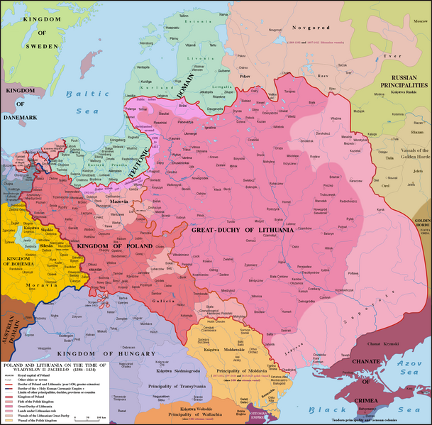
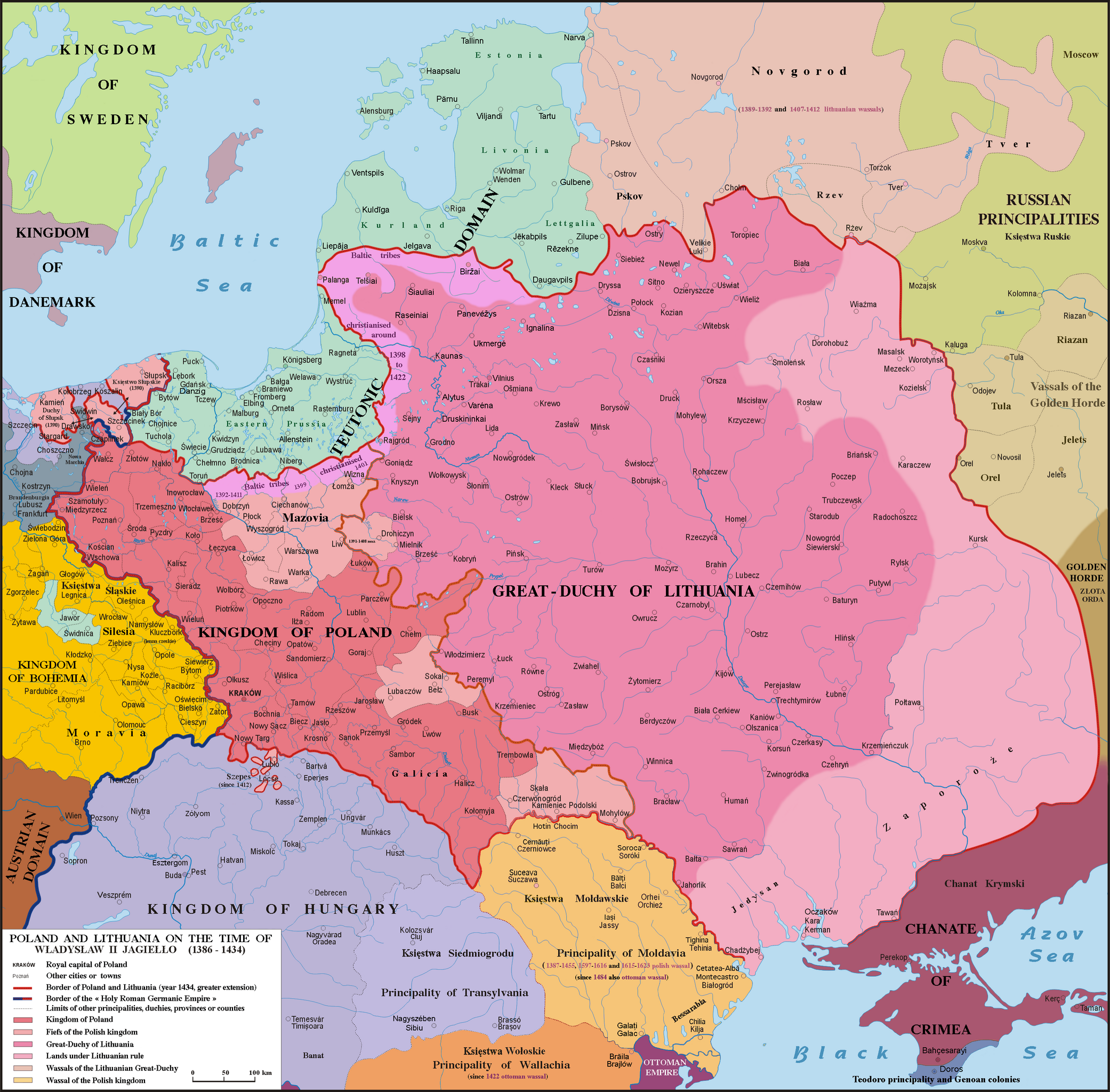
English: Map of Poland, Lithuania & neighbourough 1386-1434. Graphic derivative map since https://fr.wikipedia.org/wiki/Yedisan#/media/File:Polska_1386_-_1434.png but English version and without the 5 mistakes of the original map (impossible to be corrected because the first uploader reverts the new versions) : 1)- Moldavia wasn't a province or a fief (lenno in polish) of the Polish kingdom, but a principality, vassal of Poland from 1387 to 1455, from 1597 to 1616 & from 1615 to 1623 : the Moldavian prince were not a Polish sir appointed by the polish King but a Moldavian boyard elected by the Moldavian Sfat ; 2)- The name Hospodar for the Moldavian princes aren’t in use before the XVIth century ; 3)- In this time Kilja was on the south side of Chilia arm (today Chilia Veche in Romania, not the new Kilija in Ukraine) ; 4)- Danube delta was moldavian till 1484 and the shoreline was different in 1400 ; 5)- Akkerman is not another town but the turkish name (given since 1484) of Bialgorod also named in this time Cetatea-Alba & Montecastro. Sources: Hans-Erich Stier (dir.) "Grosser Atlas zur Weltgeschichte", Ed. Westermann 1985, ISBN 3-14-100919-8, "Történelmi atlasz", Magyar Academy 1991, ISBN 963-351422-3 CM, "Atlas istorico-geografic", Ed. Academica 1994, ISBN 973-27-0500-0, Constantin C. Giurescu & Dinu C. Giurescu :" History of the Romanian lands", Ed. Academica 1985, p.209-210, N. P. Comneanu: "Les principautés roumaines à travers les âges", Ed. Payot, Paris 1919 and Lucian Predescu: "Enciclopedia Cugetarea", p.562-563.
Lietuvių: Lietuvos Didžiosios Kunigaikštystės (rožinė) ir Lenkijos Karalystės Karūnos (raudona) žemėlapis valdant Jogailai 1386 - 1434 m.
Polski: Mapa Polski i Litwy za panowania Władysława II Jagiełły (1386 - 1434). |
| Datums | |
| Avots | File:Polska 1386 - 1434.png |
| Autors |
Poznaniak (original image) Spiridon Ion Cepleanu (derivative work) |
Licence
Es, šī darba autortiesību īpašnieks, publicēju to saskaņā ar šo licenci:
This file is licensed under the Creative Commons Attribution-Share Alike 4.0 International license.
- Jūs varat brīvi:
- koplietot – kopēt, izplatīt un pārraidīt darbu
- remiksēt – pielāgot darbu
- Saskaņā ar šādiem nosacījumiem:
- atsaucoties – Tev ir jānorāda autors, saite uz licenci un to, vai veiktas kādas izmaiņas. To var darīt jebkādā saprātīgā veidā, bet ne tādā, kas norādītu, ka licencētājs atbalsta tevi vai veidu, kā tu izmanto šo darbu.
- nemainot licenci – Ja tu miksē, pārveido vai izmanto materiālu, tev savs devums jāpublicē ar to pašu vai saderīgu licenci kā oriģināls.
Faila hronoloģija
Uzklikšķini uz datums/laiks kolonnā esošās saites, lai apskatītos, kā šis fails izskatījās tad.
| Datums/Laiks | Attēls | Izmēri | Dalībnieks | Komentārs | |
|---|---|---|---|---|---|
| tagadējais | 2016. gada 10. maijs, plkst. 20.18 | | 2 977 × 2 929 (2,13 MB) | Julieta39 | Teodoro principality in Crimea until 1475 |
| 2015. gada 6. decembris, plkst. 19.11 |  | 2 977 × 2 929 (2,14 MB) | Spiridon Ion Cepleanu | Correct orthograph of Lithuania in english | |
| 2015. gada 6. decembris, plkst. 16.56 |  | 2 977 × 2 929 (2,14 MB) | Spiridon Ion Cepleanu | User created page with UploadWizard |
Faila lietojums
Šo failu izmanto šajā 1 lapā:
Globālais faila lietojums
Šīs Vikipēdijas izmanto šo failu:
- Izmantojums af.wikipedia.org
- Izmantojums als.wikipedia.org
- Izmantojums ar.wikipedia.org
- Izmantojums az.wikipedia.org
- Izmantojums be.wikipedia.org
- Izmantojums bg.wikipedia.org
- Izmantojums br.wikipedia.org
- Izmantojums ca.wikipedia.org
- Izmantojums cs.wikipedia.org
- Izmantojums da.wikipedia.org
- Izmantojums de.wikipedia.org
- Izmantojums de.wikibooks.org
- Izmantojums de.wikiversity.org
- Izmantojums el.wikipedia.org
- Izmantojums en.wikipedia.org
- Izmantojums et.wikipedia.org
- Izmantojums fa.wikipedia.org
- Izmantojums fi.wikipedia.org
- Izmantojums fr.wikipedia.org
- Izmantojums gd.wikipedia.org
- Izmantojums hu.wikipedia.org
- Izmantojums it.wikipedia.org
- Izmantojums ja.wikipedia.org
- Izmantojums lt.wikipedia.org
- Izmantojums lt.wikibooks.org
- Izmantojums sl.wikipedia.org
_and_the_Crown_of_the_Kingdom_of_Poland_(red)_and_its_neighborhood_in_1386_–_1434_(English_version).png)