
Attēls:Mazowieckie mapa fizyczna.png

Šī priekšskata izmērs: 579 × 600 pikseļi. Citi izmēri: 232 × 240 pikseļi | 463 × 480 pikseļi | 741 × 768 pikseļi | 988 × 1 024 pikseļi | 1 977 × 2 048 pikseļi | 3 120 × 3 232 pikseļi.
Sākotnējais fails (3 120 × 3 232 pikseļi, faila izmērs: 940 KB, MIME tips: image/png)
| Šis fails ir no Vikikrātuves. Tā apraksts no attēla lapas Vikikrātuvē ir parādīts zemāk. Vikikrātuve ir brīvi licencēta failu krātuve. Tu vari tai palīdzēt. |
| Apraksts |
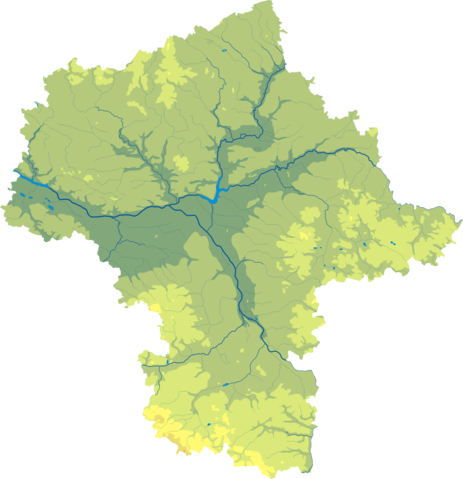
Polski: Mapa wód i ukształtowania powierzchni województwa opolskiego mazowieckiego.
Współrzędne graniczne mapy:
English: Relief map of Masovian Voivodeship. |
||
| Datums | |||
| Avots | Mazowieckie mapa fizyczna, which was created and published under GFDL-self by Aotearoa. | ||
| Autors | Aotearoa | ||
| Atļauja: (Šī faila izmantošana citur) |
|

Legend

Faila hronoloģija
Uzklikšķini uz datums/laiks kolonnā esošās saites, lai apskatītos, kā šis fails izskatījās tad.
| Datums/Laiks | Attēls | Izmēri | Dalībnieks | Komentārs | |
|---|---|---|---|---|---|
| tagadējais | 2012. gada 29. oktobris, plkst. 13.43 | | 3 120 × 3 232 (940 KB) | Aotearoa | drobne techniczne |
| 2007. gada 12. februāris, plkst. 05.51 |  | 637 × 657 (121 KB) | Bonas | {{Information |Description= Relief map of Masovian Voivodeship. |Source= Mazowieckie mapa fizyczna, which was created and published under GFDL-self by [[:pl:Wikipedysta:Aotearoa|A |
Faila lietojums
Šo failu izmanto šajā 1 lapā:
Globālais faila lietojums
Šīs Vikipēdijas izmanto šo failu:
- Izmantojums be-tarask.wikipedia.org
- Izmantojums be.wikipedia.org
- Izmantojums bg.wikipedia.org
- Варшава
- Радом
- Пултуск
- Мшчонов
- Гостинин
- Гура Калвария
- Плоцк
- Остроленка
- Шедълце
- Прушков
- Легьоново
- Чеханов
- Отвоцк
- Пясечно
- Жирардов
- Сохачев
- Минск Мазовецки
- Воломин
- Млава (град)
- Зомбки
- Гроджиск Мазовецки
- Нови Двур Мазовецки
- Вишков
- Марки
- Пястов
- Остров Мазовецка
- Плонск
- Стар град във Варшава
- Бялобжеги
- Венгров
- Гарволин
- Груйец
- Журомин
- Ожаров Мазовецки
- Зволен (Полша)
- Коженице
- Липско
- Лошице
- Маков Мазовецки
- Пшасниш
- Пшисуха
- Соколов Подляски
- Шерпц
- Шидловец
- Кобилка
- Жельонка (Воломински окръг)
- Пьонки
- Сулейовек
Skatīt šī faila pilno globālo izmantojumu.